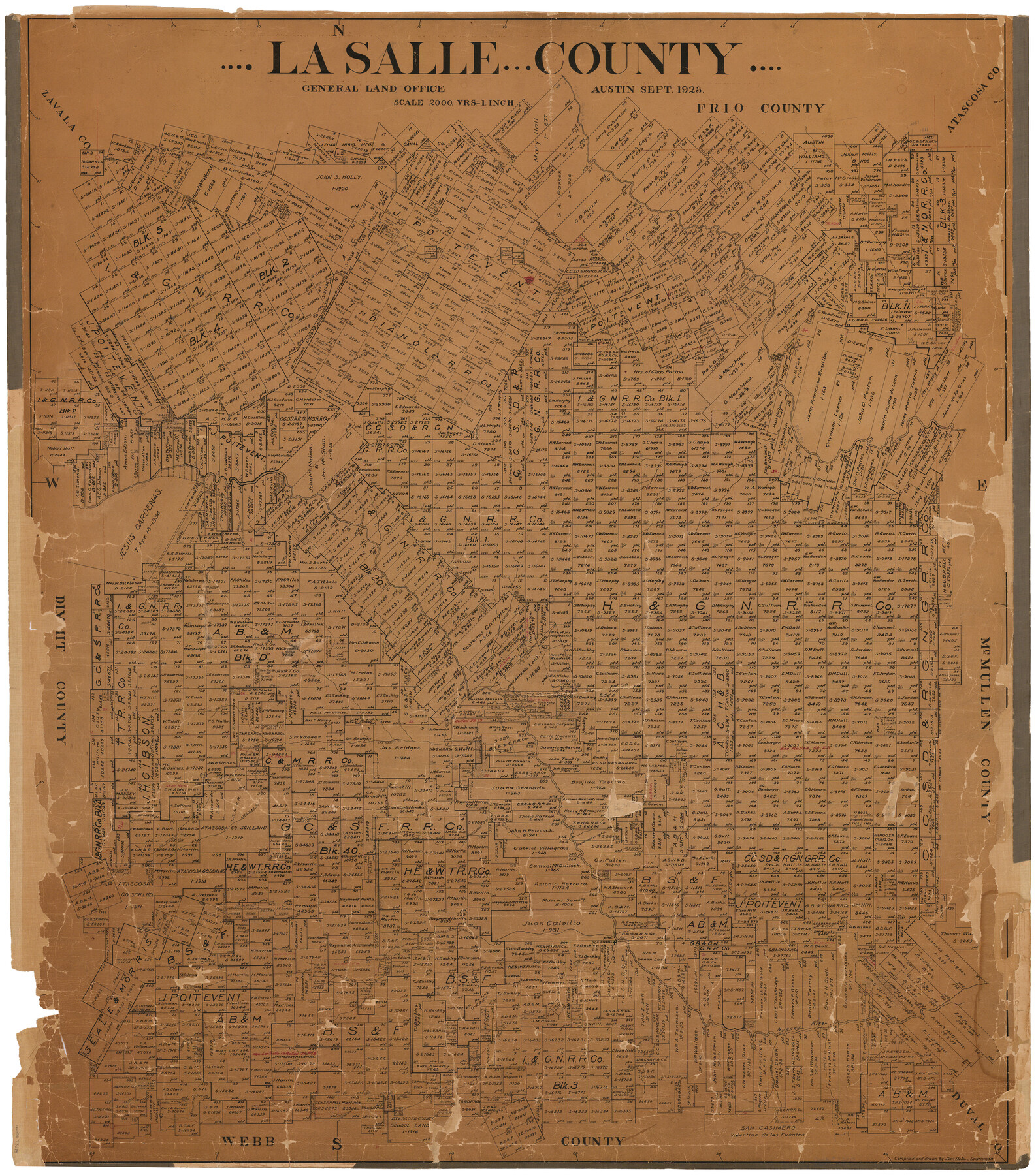
La Salle County
-
Map/Doc
73215
-
Collection
General Map Collection
-
Object Dates
9/1923 (Creation Date)
-
People and Organizations
Texas General Land Office (Publisher)
Tom G. Atlee (Draftsman)
Tom G. Atlee (Compiler)
-
Counties
La Salle
-
Subjects
County
-
Height x Width
47.5 x 42.5 inches
120.7 x 108.0 cm
-
Features
El Paso Road
East Fork of Piedras Creek
West Fork of Piedras Creek
Olmos Creek
La Mota Creek
Lake [East of La Mota Creek]
Fort Ewell
Mojaras Creek
Caiman Creek
El Oso Creek
Los Indios Creek
Tecolote Creek
Chucoreco Creek
Cochino Road
Old El Paso Road
Oso Creek
Laguna Petamosa
Old San Antonio Road
Cristal Hill
Jaboncillos Creek
Laredo Road
Charco Largo Creek
Laguna Retacosa
Encinal
Paco Blanco Road
El Frijol Ranch
Old San Antonio to Laredo Road
San Casimero Creek
Prieto Creek
Charamusca Creek
Harris Lake
Esperanza Creek
Millett
Johny Creek
Sauz Creek
Elm Creek
SAU&G
Gardendale
Dobson
Gayman Creek
Fowlerton
Dull
Los Angeles
Cotulla
Nueces River
Frio River
Mustang Creek
Altito Ranch
Altito Creek
I&GN
Harris Creek
Sutton's Ranch
Second Elm Creek
Live Oak Creek
First Elm Creek
Artesia Wells
Las Raices Creek
Almito Creek
Galapago Creek
Part of: General Map Collection
Fayette County Sketch File 4

Print $4.00
- Digital $50.00
Fayette County Sketch File 4
Size 11.7 x 7.9 inches
Map/Doc 22504
Erath County Boundary File 1

Print $8.00
- Digital $50.00
Erath County Boundary File 1
Size 13.1 x 8.8 inches
Map/Doc 53237
Map of Val Verde County

Print $20.00
- Digital $50.00
Map of Val Verde County
1898
Size 42.9 x 37.5 inches
Map/Doc 63098
Briscoe County Working Sketch 6

Print $20.00
- Digital $50.00
Briscoe County Working Sketch 6
1940
Size 31.0 x 24.5 inches
Map/Doc 67809
Flight Mission No. DQN-6K, Frame 72, Calhoun County

Print $20.00
- Digital $50.00
Flight Mission No. DQN-6K, Frame 72, Calhoun County
1953
Size 18.4 x 22.0 inches
Map/Doc 84444
Brazoria County Working Sketch 11

Print $20.00
- Digital $50.00
Brazoria County Working Sketch 11
1935
Size 18.1 x 24.3 inches
Map/Doc 67496
Kinney County Sketch File 34

Print $8.00
- Digital $50.00
Kinney County Sketch File 34
1941
Size 14.2 x 8.8 inches
Map/Doc 29181
Texas Gulf Coast, from the Sabine River to the Rio Grande as Subdivided for Mineral Development; Matagorda, Calhoun and Aransas Counties

Print $40.00
- Digital $50.00
Texas Gulf Coast, from the Sabine River to the Rio Grande as Subdivided for Mineral Development; Matagorda, Calhoun and Aransas Counties
1976
Size 43.0 x 90.9 inches
Map/Doc 1939
Ward County State of Texas

Print $20.00
- Digital $50.00
Ward County State of Texas
1888
Size 22.6 x 26.0 inches
Map/Doc 4641
Fisher County Working Sketch 16

Print $20.00
- Digital $50.00
Fisher County Working Sketch 16
1958
Size 34.6 x 37.4 inches
Map/Doc 69150
Map of the County of Cameron

Print $40.00
- Digital $50.00
Map of the County of Cameron
1884
Size 59.4 x 35.8 inches
Map/Doc 76058
Refugio County

Print $20.00
- Digital $50.00
Refugio County
1883
Size 20.1 x 28.9 inches
Map/Doc 3984
You may also like
Caldwell County Working Sketch 11

Print $20.00
- Digital $50.00
Caldwell County Working Sketch 11
1979
Size 21.6 x 26.6 inches
Map/Doc 67841
San Patricio County Rolled Sketch 46E

Print $20.00
- Digital $50.00
San Patricio County Rolled Sketch 46E
1983
Size 17.4 x 46.3 inches
Map/Doc 8376
Harris County Sketch File 56

Print $4.00
- Digital $50.00
Harris County Sketch File 56
1918
Size 8.2 x 12.8 inches
Map/Doc 25454

Nueces County Sketch File 41

Print $8.00
- Digital $50.00
Nueces County Sketch File 41
Size 11.1 x 8.6 inches
Map/Doc 32629
Map of Tascosa, Oldham County, Texas

Print $40.00
- Digital $50.00
Map of Tascosa, Oldham County, Texas
Size 34.8 x 66.8 inches
Map/Doc 89711
Uvalde County Working Sketch 8

Print $20.00
- Digital $50.00
Uvalde County Working Sketch 8
1942
Size 37.4 x 23.6 inches
Map/Doc 72078
Flight Mission No. DQN-1K, Frame 136, Calhoun County

Print $20.00
- Digital $50.00
Flight Mission No. DQN-1K, Frame 136, Calhoun County
1953
Size 18.5 x 22.3 inches
Map/Doc 84199
Andrews County Rolled Sketch 45

Print $40.00
- Digital $50.00
Andrews County Rolled Sketch 45
1946
Size 111.7 x 41.0 inches
Map/Doc 8402
Jasper County Sketch File 20

Print $4.00
- Digital $50.00
Jasper County Sketch File 20
Size 8.7 x 12.2 inches
Map/Doc 27818
Comal County Working Sketch 1

Print $20.00
- Digital $50.00
Comal County Working Sketch 1
1919
Size 22.1 x 18.2 inches
Map/Doc 68167
Map of Frio County, Texas

Print $20.00
- Digital $50.00
Map of Frio County, Texas
1879
Size 24.1 x 22.5 inches
Map/Doc 5032