Kinney County Sketch File 34
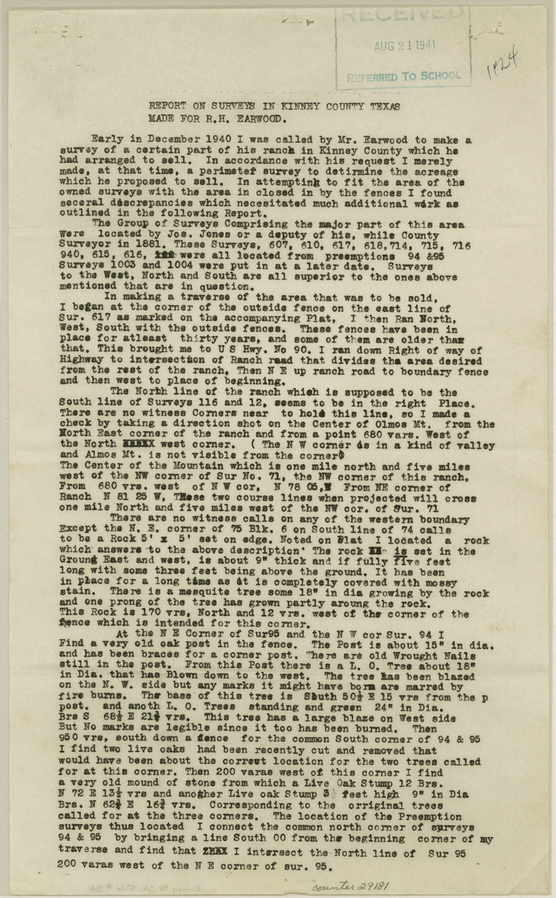
Report on surveys in Kinney County, Texas made for R.H. Earwood
-
Map/Doc
29181
-
Collection
General Map Collection
-
Object Dates
6/24/1941 (Creation Date)
8/21/1941 (File Date)
-
People and Organizations
C.H. Mullins (Surveyor/Engineer)
-
Counties
Kinney
-
Subjects
Surveying Sketch File
-
Height x Width
14.2 x 8.8 inches
36.1 x 22.4 cm
-
Medium
paper, print
-
Comments
See Kinney County Rolled Sketch 9 (6538).
-
Features
U.S. Highway 90
Olmos Mountain
Almos Mountain
Elm Creek
Turkey Creek
GH&SA
Anacacho Ranch
Related maps
Kinney County Rolled Sketch 9

Print $20.00
- Digital $50.00
Kinney County Rolled Sketch 9
Size 39.4 x 27.5 inches
Map/Doc 6538
Part of: General Map Collection
Kendall County Working Sketch 18

Print $20.00
- Digital $50.00
Kendall County Working Sketch 18
1970
Size 43.2 x 33.3 inches
Map/Doc 66690
Map of Erath County

Print $20.00
- Digital $50.00
Map of Erath County
1872
Size 20.2 x 19.8 inches
Map/Doc 3521
Edwards County Working Sketch 105

Print $40.00
- Digital $50.00
Edwards County Working Sketch 105
1972
Size 54.9 x 36.2 inches
Map/Doc 62186
Intracoastal Waterway, Houma, LA to Corpus Christi, TX

Print $4.00
- Digital $50.00
Intracoastal Waterway, Houma, LA to Corpus Christi, TX
Size 23.8 x 22.0 inches
Map/Doc 61910
Flight Mission No. DIX-10P, Frame 171, Aransas County

Print $20.00
- Digital $50.00
Flight Mission No. DIX-10P, Frame 171, Aransas County
1956
Size 18.8 x 22.3 inches
Map/Doc 83961
Coleman County

Print $20.00
- Digital $50.00
Coleman County
1858
Size 25.2 x 22.5 inches
Map/Doc 3409
Travis County Boundary File 4

Print $52.00
- Digital $50.00
Travis County Boundary File 4
Size 9.5 x 8.2 inches
Map/Doc 59420
Dickens County Sketch File D1

Print $50.00
- Digital $50.00
Dickens County Sketch File D1
Size 13.0 x 19.4 inches
Map/Doc 20833
Leon County Sketch File 28

Print $8.00
- Digital $50.00
Leon County Sketch File 28
1951
Size 11.2 x 8.7 inches
Map/Doc 29821
Flight Mission No. BRE-3P, Frame 79, Nueces County

Print $20.00
- Digital $50.00
Flight Mission No. BRE-3P, Frame 79, Nueces County
1956
Size 18.6 x 22.5 inches
Map/Doc 86820
Jeff Davis County Rolled Sketch 26

Print $20.00
- Digital $50.00
Jeff Davis County Rolled Sketch 26
1957
Size 25.1 x 42.3 inches
Map/Doc 6374
Fort Bend County Working Sketch 3

Print $20.00
- Digital $50.00
Fort Bend County Working Sketch 3
1897
Size 26.8 x 24.6 inches
Map/Doc 69209
You may also like
Cottle County, Texas

Print $20.00
- Digital $50.00
Cottle County, Texas
1891
Size 23.1 x 17.0 inches
Map/Doc 619
Dimmit County Sketch File 44

Print $20.00
- Digital $50.00
Dimmit County Sketch File 44
Size 16.3 x 19.5 inches
Map/Doc 11354
Garza County Working Sketch 8

Print $40.00
- Digital $50.00
Garza County Working Sketch 8
1950
Size 37.4 x 48.0 inches
Map/Doc 63155
Chambers County Working Sketch 7

Print $20.00
- Digital $50.00
Chambers County Working Sketch 7
1939
Size 30.6 x 39.6 inches
Map/Doc 67990
Crockett County

Print $20.00
- Digital $50.00
Crockett County
1920
Size 44.8 x 32.9 inches
Map/Doc 92548
Calhoun County NRC Article 33.136 Sketch 11

Digital $50.00
Calhoun County NRC Article 33.136 Sketch 11
2023
Map/Doc 97255
Madison County

Print $20.00
- Digital $50.00
Madison County
1871
Size 14.0 x 19.6 inches
Map/Doc 3833
Concho County Sketch File 39

Print $8.00
- Digital $50.00
Concho County Sketch File 39
1949
Size 11.3 x 8.8 inches
Map/Doc 19190
Rio Grande, Run Sheet

Print $2.00
- Digital $50.00
Rio Grande, Run Sheet
1931
Size 17.0 x 14.3 inches
Map/Doc 65120
Stonewall County Sketch File B2

Print $20.00
- Digital $50.00
Stonewall County Sketch File B2
1902
Size 25.8 x 25.0 inches
Map/Doc 12377
Rio Grande Rectification Project, El Paso and Juarez Valley

Print $20.00
- Digital $50.00
Rio Grande Rectification Project, El Paso and Juarez Valley
1935
Size 11.0 x 29.7 inches
Map/Doc 60864
Hamilton County Sketch File 10

Print $24.00
- Digital $50.00
Hamilton County Sketch File 10
1874
Size 12.8 x 8.5 inches
Map/Doc 24919