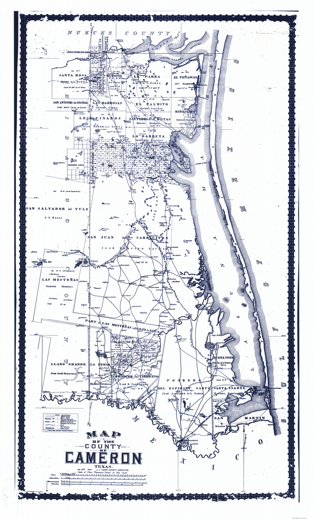
Map of the County of Cameron
-
Map/Doc
76058
-
Collection
General Map Collection
-
Object Dates
10/25/1884 (Creation Date)
-
People and Organizations
Rand, McNally, and Company, Engravers and Printer (Publisher)
Rand McNally and Company (Printer)
J.J. Cocke (Surveyor/Engineer)
J.J. Cocke (Compiler)
-
Counties
Cameron
-
Subjects
County
-
Height x Width
59.4 x 35.8 inches
150.9 x 90.9 cm
-
Comments
See counter 3141 for black and white copy of same map.
-
Features
La Boveda Ranch
Alazan Bay
Agua Dulce Creek
Baffin's Bay
Point Penascal
Laguna Salada
Paso D[]o Landing
La Parra Ranch
Mota Cobos
Mota de Trancas
Paso de la Carreta
Paso de la Piedra
Paso de Tio Pancho
Paso de la Pita
Arroyo de los Olmos
Loma Tunas
La Purisima [Ranch]
Atravesada
Mota Negra
Rock Pen Landing
Rocky Bayou
Bayou Atascosa
Salt Lake
Palmito Ranch
Mota de Tio Culas
Mota del Sierpe
Mota Raia
Los Indios
San Juan
Las Vivoritas
Laguna del Mezquite
Old San Pedro
New San Pedro
Round Mota
Mota del Nido
Mota del Gato
Mota de Ojo de Agua
Mota de Borregos
Mota del Campo
Alazon Ranch
Santa Quiteria Ranch
Candelaria Motts
Los Tullidos Motts
Mota Mirion
San Ignacio
Soledad
Topo
Sauceda
Topo Viejo
Atravesada
San Jose
Salates
Saltillo
Chiltipin
Loma Prieta
Mota Devisadera
Las Animas
Florida
Santa Lucia
San Luis
Campo Verde Mota
Refugio
Medanos Blancos
Portales
Badeno
Tajitos
Buena Vista
Alazan
Motas de Los Arrieros
Mogote Don Juan
Punta del Monte
San Francisco
Carricitas Viejo
Palmital
El Coyote [Ranch]
La Teneria
Los Magotes [Ranch]
San Andres
Santo Domingo
Chata
Rancho Nuevo
Cruz Verde
Lasal
Sal Viega Ranch
Rancho La Tordilla
La Jana [Ranch]
Laguna Cardena
Costales Pond
El Rucio [Ranch]
Valle Hermoso [Ranch]
Santa Monica
San Tadeo
Tresquilas
Chapote
Nuevo Carmel
Sombrerito
El Toro
San Gregorio [Ranch]
El Sauz [Ranch]
Quemada [Ranch]
Loma Alta
Ovejas [Ranch]
Mutatos [Ranch]
San Pedro
San Juan
La Cruz [Ranch]
La Rucia [Ranch]
Laguna Largo
Becerrita [Ranch]
Felipeño
Las Jarras [Ranch]
Como se Llama [Ranch]
Chapaneca [Ranch]
Magueyal [Ranch]
San Nicolas
La Piedra [Ranch]
Las Petitas
Sabinito
San Matias
Los Coyotes [Ranch]
Tres Norias [Ranch]
Veladeros [Ranch]
Venadito [Ranch]
Jarita [Ranch]
Mezquite [Ranch]
Cuatizones [Ranch]
Paso de Las Tavernas
Capitaneño [Ranch]
Paso Real
Carreta [Ranch]
Arroyo Colorado
Alazon [Ranch]
Tizones [Ranch]
Calaboso [Ranch]
Chatones [Ranch]
Cotillo [Ranch]
El Pie [Ranch]
San Jose
Santa Rita [Ranch]
Los Burros [Ranch]
Laguna de Pales
Retama Ranch
Colimal [Ranch]
Los Clemores [Ranch]
Laguna Larga
Anacuttas [Ranch]
India
Laguna Madre
Gulf of Mexico
Agua Negra
Noria [Ranch]
Higueras [Ranch]
Santa Maria [Ranch]
Zacatal [Ranch]
Esterito [Ranch]
Rosario [Ranch]
La Blanca [Ranch]
Rucias [Ranch]
Puerta Panola
Venados [Ranch]
Galveston [Ranch]
Carricitos [Ranch]
Barranco [Ranch]
Confirmation San Pedro [Ranch]
Palo Alto Battleground
Vicente [Ranch]
Rosita [Ranch]
San Pedro [Ranch]
Gloria [Ranch]
Carmel [Ranch]
Villa Nueva [Ranch]
Santa Rita [Ranch]
Concepcion [Ranch]
Prietas [Ranch]
Ramireno [Ranch]
Brownsville
Santa Rosalia [Ranch]
Tangue [Ranch]
Part of: General Map Collection
Howard County Sketch File 2a

Print $20.00
- Digital $50.00
Howard County Sketch File 2a
1909
Size 32.8 x 25.6 inches
Map/Doc 11792
America's Fun-Tier: Texas 1965 Official Highway Travel Map

Digital $50.00
America's Fun-Tier: Texas 1965 Official Highway Travel Map
Size 28.2 x 36.4 inches
Map/Doc 94325
Jeff Davis County Rolled Sketch 9

Print $20.00
- Digital $50.00
Jeff Davis County Rolled Sketch 9
Size 18.3 x 22.9 inches
Map/Doc 6362
Pecos County Working Sketch 97

Print $40.00
- Digital $50.00
Pecos County Working Sketch 97
1970
Size 35.7 x 48.9 inches
Map/Doc 71570
Crockett County Sketch File 74

Print $22.00
- Digital $50.00
Crockett County Sketch File 74
1933
Size 11.4 x 8.6 inches
Map/Doc 19872
Houston County Working Sketch 6

Print $20.00
- Digital $50.00
Houston County Working Sketch 6
1933
Size 37.1 x 30.8 inches
Map/Doc 66236
Mason County Working Sketch 11

Print $20.00
- Digital $50.00
Mason County Working Sketch 11
1951
Size 24.7 x 23.7 inches
Map/Doc 70847
Map of Castro's Colony - Bexar District

Print $20.00
- Digital $50.00
Map of Castro's Colony - Bexar District
1851
Size 36.4 x 33.1 inches
Map/Doc 1962
Right of Way & Track Map Houston & Brazos Valley Ry. operated by Houston & Brazos Valley Ry. Co., Hoskins Mound Branch

Print $40.00
- Digital $50.00
Right of Way & Track Map Houston & Brazos Valley Ry. operated by Houston & Brazos Valley Ry. Co., Hoskins Mound Branch
1924
Size 25.3 x 56.4 inches
Map/Doc 64611
Lynn County Rolled Sketch 16

Print $20.00
- Digital $50.00
Lynn County Rolled Sketch 16
1991
Size 18.3 x 42.3 inches
Map/Doc 6652
Dimmit County Sketch File 49

Print $20.00
- Digital $50.00
Dimmit County Sketch File 49
1909
Size 17.3 x 26.8 inches
Map/Doc 11358
Cooke County Working Sketch 15

Print $20.00
- Digital $50.00
Cooke County Working Sketch 15
1946
Size 29.9 x 23.5 inches
Map/Doc 68252
You may also like
West Part of Liberty Co.

Print $20.00
- Digital $50.00
West Part of Liberty Co.
1977
Size 43.5 x 32.9 inches
Map/Doc 77353
Reagan County Working Sketch 28

Print $40.00
- Digital $50.00
Reagan County Working Sketch 28
1963
Size 55.7 x 42.4 inches
Map/Doc 71870
![91965, [PSL Block B19], Twichell Survey Records](https://historictexasmaps.com/wmedia_w700/maps/91965-1.tif.jpg)
Brewster County Rolled Sketch 144

Print $40.00
- Digital $50.00
Brewster County Rolled Sketch 144
Size 51.7 x 48.3 inches
Map/Doc 8526
Cameron County Rolled Sketch 20B

Print $20.00
- Digital $50.00
Cameron County Rolled Sketch 20B
1960
Size 25.2 x 13.5 inches
Map/Doc 5472
Flight Mission No. CGI-1N, Frame 186, Cameron County

Print $20.00
- Digital $50.00
Flight Mission No. CGI-1N, Frame 186, Cameron County
1955
Size 18.5 x 22.1 inches
Map/Doc 84521
Crockett County Sketch File 12

Print $20.00
- Digital $50.00
Crockett County Sketch File 12
Size 26.8 x 18.9 inches
Map/Doc 11216
Little River, Widths of Floodways

Print $6.00
- Digital $50.00
Little River, Widths of Floodways
1921
Size 23.2 x 34.9 inches
Map/Doc 65070
Runnels County Working Sketch 24

Print $20.00
- Digital $50.00
Runnels County Working Sketch 24
1952
Size 30.6 x 20.0 inches
Map/Doc 63620
Gaines County Boundary File 2

Print $42.00
- Digital $50.00
Gaines County Boundary File 2
Size 11.5 x 52.3 inches
Map/Doc 53652
McMullen County Working Sketch 40

Print $40.00
- Digital $50.00
McMullen County Working Sketch 40
1975
Size 48.3 x 34.8 inches
Map/Doc 70741
Right of Way & Track Map, St. Louis, Brownsville & Mexico Ry. operated by St. Louis, Brownsville & Mexico Ry. Co.

Print $40.00
- Digital $50.00
Right of Way & Track Map, St. Louis, Brownsville & Mexico Ry. operated by St. Louis, Brownsville & Mexico Ry. Co.
1919
Size 25.7 x 57.1 inches
Map/Doc 64625