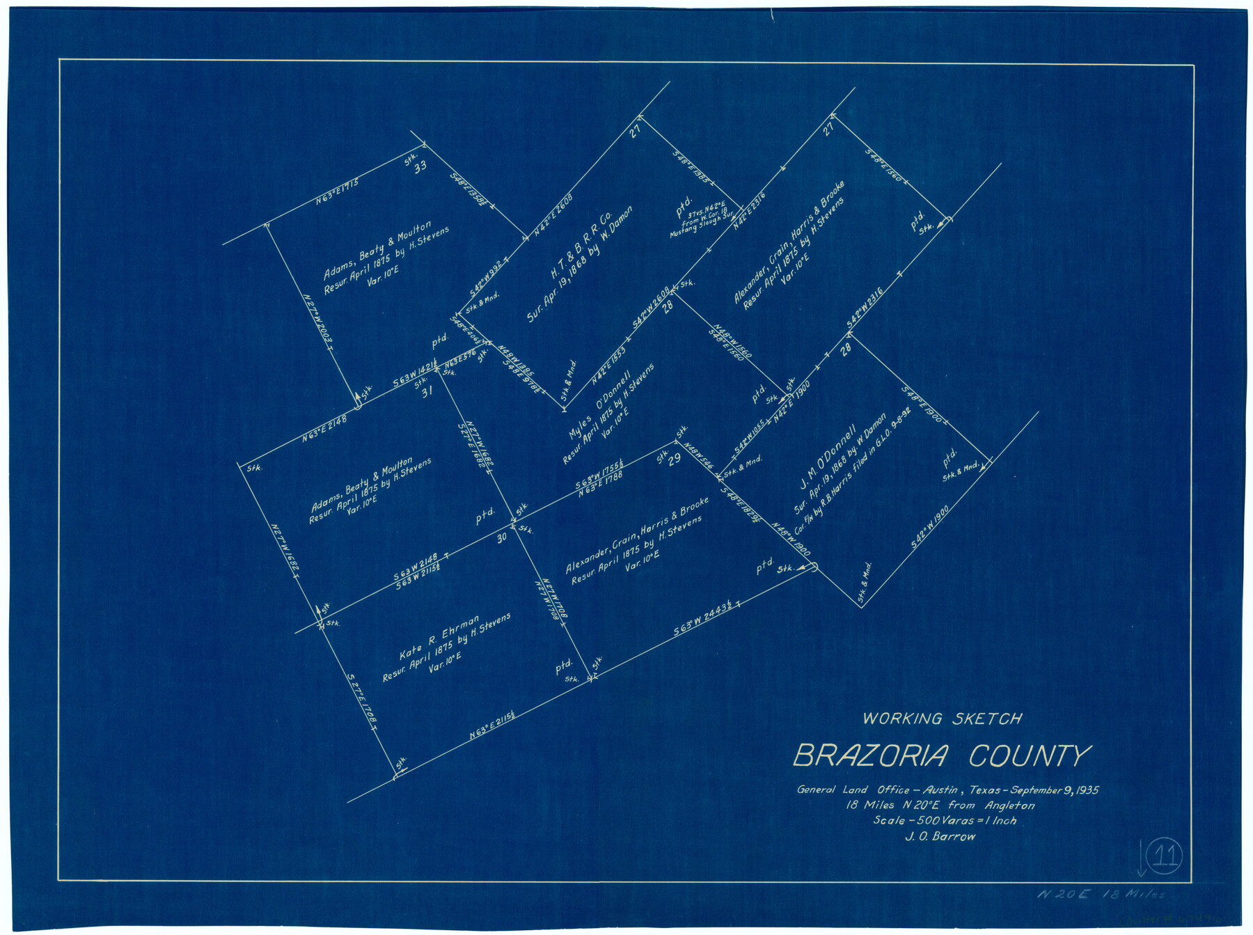
Brazoria County Working Sketch 11
-
Map/Doc
67496
-
Collection
General Map Collection
-
Object Dates
9/9/1935 (Creation Date)
-
People and Organizations
J.O. Barrow (Draftsman)
-
Counties
Brazoria
-
Subjects
Surveying Working Sketch
-
Height x Width
18.1 x 24.3 inches
46.0 x 61.7 cm
-
Scale
1" = 500 varas
-
Comments
Surveys located about 18 miles North 20 degrees East of Angleton, Texas.
Part of: General Map Collection
Flight Mission No. CUG-1P, Frame 72, Kleberg County

Print $20.00
- Digital $50.00
Flight Mission No. CUG-1P, Frame 72, Kleberg County
1956
Size 18.6 x 22.1 inches
Map/Doc 86137
Map of Yoakum County

Print $40.00
- Digital $50.00
Map of Yoakum County
1900
Size 51.2 x 38.7 inches
Map/Doc 4169
Reagan County Sketch File 13

Print $40.00
- Digital $50.00
Reagan County Sketch File 13
1931
Size 15.6 x 15.1 inches
Map/Doc 34991
Map of Panola County

Print $20.00
- Digital $50.00
Map of Panola County
1871
Size 16.5 x 17.7 inches
Map/Doc 3938
Red River County Working Sketch 12

Print $20.00
- Digital $50.00
Red River County Working Sketch 12
Size 17.3 x 20.0 inches
Map/Doc 71995
Aransas County Rolled Sketch 19B

Print $20.00
- Digital $50.00
Aransas County Rolled Sketch 19B
1979
Size 25.7 x 18.7 inches
Map/Doc 76077
Map of Palo Pinto County Texas

Print $20.00
- Digital $50.00
Map of Palo Pinto County Texas
1879
Size 22.0 x 17.3 inches
Map/Doc 3933
Brewster County Sketch File NS-14

Print $160.00
- Digital $50.00
Brewster County Sketch File NS-14
1970
Size 8.2 x 6.5 inches
Map/Doc 16224
Titus County Sketch File 10

Print $4.00
- Digital $50.00
Titus County Sketch File 10
1871
Size 8.1 x 12.9 inches
Map/Doc 38148
Flight Mission No. DQN-1K, Frame 153, Calhoun County

Print $20.00
- Digital $50.00
Flight Mission No. DQN-1K, Frame 153, Calhoun County
1953
Size 18.6 x 22.3 inches
Map/Doc 84212
Houston Ship Channel, Atkinson Island to Alexander Island

Print $40.00
- Digital $50.00
Houston Ship Channel, Atkinson Island to Alexander Island
1992
Size 37.1 x 54.3 inches
Map/Doc 69904

You may also like
Potter County Boundary File 5a

Print $80.00
- Digital $50.00
Potter County Boundary File 5a
Size 13.0 x 71.0 inches
Map/Doc 58024

[Texas Boundary Line]
![92077, [Texas Boundary Line], Twichell Survey Records](https://historictexasmaps.com/wmedia_w700/maps/92077-1.tif.jpg)
Print $20.00
- Digital $50.00
[Texas Boundary Line]
Size 21.2 x 12.0 inches
Map/Doc 92077
Angelina County Working Sketch 21

Print $20.00
- Digital $50.00
Angelina County Working Sketch 21
1947
Size 35.7 x 35.8 inches
Map/Doc 67102
Crockett County Working Sketch 94

Print $20.00
- Digital $50.00
Crockett County Working Sketch 94
1979
Size 43.1 x 28.7 inches
Map/Doc 68427
Presidio County Working Sketch 78

Print $4.00
- Digital $50.00
Presidio County Working Sketch 78
1965
Size 24.8 x 25.1 inches
Map/Doc 71755
Knox County Rolled Sketch 11

Print $20.00
- Digital $50.00
Knox County Rolled Sketch 11
Size 24.4 x 17.3 inches
Map/Doc 6557
Roberts County Working Sketch 29

Print $20.00
- Digital $50.00
Roberts County Working Sketch 29
1983
Size 18.6 x 34.8 inches
Map/Doc 63555
Flight Mission No. DIX-10P, Frame 69, Aransas County

Print $20.00
- Digital $50.00
Flight Mission No. DIX-10P, Frame 69, Aransas County
1956
Size 18.8 x 22.4 inches
Map/Doc 83930
Fannin County Working Sketch 9

Print $20.00
- Digital $50.00
Fannin County Working Sketch 9
1973
Size 28.1 x 21.9 inches
Map/Doc 69163
Palo Pinto County Working Sketch 5

Print $40.00
- Digital $50.00
Palo Pinto County Working Sketch 5
1920
Map/Doc 71388
Stephens County Sketch File 14

Print $6.00
- Digital $50.00
Stephens County Sketch File 14
Size 8.2 x 5.9 inches
Map/Doc 37065