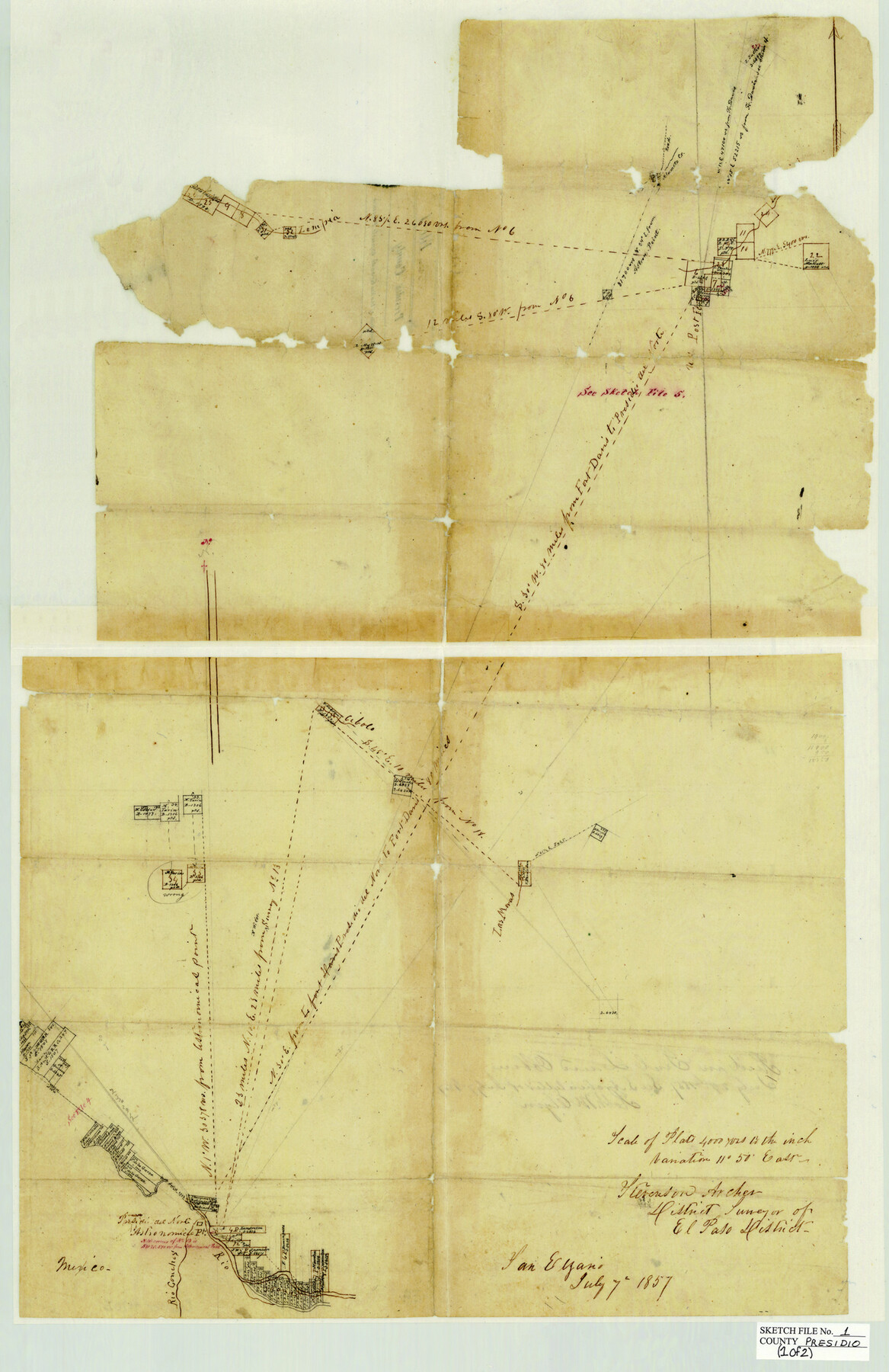
Presidio County Sketch File 1
[Two sketches with connecting lines from eastern banks of the Rio Grande]
-
Map/Doc
11703
-
Collection
General Map Collection
-
Object Dates
7/7/1857 (Creation Date)
-
People and Organizations
Clerendon Archer (Surveyor/Engineer)
-
Counties
Presidio
-
Subjects
Surveying Sketch File
-
Height x Width
24.7 x 16.0 inches
62.7 x 40.6 cm
-
Medium
paper, manuscript
-
Scale
1" = 4000 varas
-
Features
Alameto Creek
Lempia
Fort Davis
Presidio Del Norte
Cibolo
Las Moras
Rio Concho
Rio Grande
Part of: General Map Collection
Galveston County NRC Article 33.136 Sketch 69

Print $76.00
- Digital $50.00
Galveston County NRC Article 33.136 Sketch 69
2012
Size 24.0 x 36.0 inches
Map/Doc 94669
Ochiltree County Boundary File 1a

Print $4.00
- Digital $50.00
Ochiltree County Boundary File 1a
Size 11.0 x 8.5 inches
Map/Doc 57664

Marion County Working Sketch 18

Print $20.00
- Digital $50.00
Marion County Working Sketch 18
1957
Size 36.4 x 40.3 inches
Map/Doc 70794
Map showing survey for proposed ship channel from Brownsville to Brazos Santiago Pass

Print $20.00
- Digital $50.00
Map showing survey for proposed ship channel from Brownsville to Brazos Santiago Pass
1912
Size 18.1 x 28.7 inches
Map/Doc 72902
Menard County Working Sketch 15

Print $20.00
- Digital $50.00
Menard County Working Sketch 15
1943
Size 18.6 x 20.6 inches
Map/Doc 70962
Runnels County Working Sketch 13

Print $20.00
- Digital $50.00
Runnels County Working Sketch 13
1950
Size 19.4 x 17.8 inches
Map/Doc 63609
Navigation Maps of Gulf Intracoastal Waterway, Port Arthur to Brownsville, Texas

Print $4.00
- Digital $50.00
Navigation Maps of Gulf Intracoastal Waterway, Port Arthur to Brownsville, Texas
1951
Size 16.8 x 21.6 inches
Map/Doc 65419
Map of the City of Corsicana (Navarro County) Texas

Print $40.00
- Digital $50.00
Map of the City of Corsicana (Navarro County) Texas
1963
Size 36.7 x 87.5 inches
Map/Doc 93675
DeWitt County Rolled Sketch 1

Print $20.00
- Digital $50.00
DeWitt County Rolled Sketch 1
1940
Size 40.5 x 39.5 inches
Map/Doc 8777
Harris County Historic Topographic 18 1/2

Print $20.00
- Digital $50.00
Harris County Historic Topographic 18 1/2
1916
Size 29.3 x 13.7 inches
Map/Doc 65829
[Sketch for Mineral Application 27670 - Strip between Simon Sanchez leagues and Trinity River]
![2866, [Sketch for Mineral Application 27670 - Strip between Simon Sanchez leagues and Trinity River], General Map Collection](https://historictexasmaps.com/wmedia_w700/maps/2866-1.tif.jpg)
Print $20.00
- Digital $50.00
[Sketch for Mineral Application 27670 - Strip between Simon Sanchez leagues and Trinity River]
1934
Size 17.3 x 36.7 inches
Map/Doc 2866
You may also like
Loving County Boundary File 2

Print $40.00
- Digital $50.00
Loving County Boundary File 2
Map/Doc 90033
Briscoe County Sketch File E

Print $40.00
- Digital $50.00
Briscoe County Sketch File E
Size 26.0 x 33.7 inches
Map/Doc 11003
Coast Chart no. 109, Aransas Pass, Aransas and Copano Bays, Texas

Print $20.00
Coast Chart no. 109, Aransas Pass, Aransas and Copano Bays, Texas
1884
Size 44.7 x 36.7 inches
Map/Doc 76227
Randall County Rolled Sketch 8

Print $20.00
- Digital $50.00
Randall County Rolled Sketch 8
Size 32.9 x 40.6 inches
Map/Doc 7429
Map from Corpus Christi to Matagorda Bays, Texas [Inset: Survey of the channel of Copono Bay]
![72976, Map from Corpus Christi to Matagorda Bays, Texas [Inset: Survey of the channel of Copono Bay], General Map Collection](https://historictexasmaps.com/wmedia_w700/maps/72976.tif.jpg)
Print $20.00
- Digital $50.00
Map from Corpus Christi to Matagorda Bays, Texas [Inset: Survey of the channel of Copono Bay]
1846
Size 18.1 x 27.5 inches
Map/Doc 72976
Starr County Rolled Sketch 45

Print $40.00
- Digital $50.00
Starr County Rolled Sketch 45
Size 17.7 x 57.5 inches
Map/Doc 9914
Shelby County Rolled Sketch 6

Print $20.00
- Digital $50.00
Shelby County Rolled Sketch 6
Size 26.7 x 20.9 inches
Map/Doc 7776
Map of Runnels County

Print $20.00
- Digital $50.00
Map of Runnels County
1858
Size 24.7 x 25.6 inches
Map/Doc 4004
Garza County Sketch File D

Print $20.00
- Digital $50.00
Garza County Sketch File D
1901
Size 18.4 x 12.2 inches
Map/Doc 11550
Map of Galveston, Turtle & East Bays & portions of the Gulf of Mexico in Chambers & Galveston Counties, Texas showing subdivision for mineral development

Print $40.00
- Digital $50.00
Map of Galveston, Turtle & East Bays & portions of the Gulf of Mexico in Chambers & Galveston Counties, Texas showing subdivision for mineral development
1945
Size 46.3 x 52.8 inches
Map/Doc 3068
Uvalde County Working Sketch 5

Print $20.00
- Digital $50.00
Uvalde County Working Sketch 5
1927
Size 13.4 x 18.0 inches
Map/Doc 72075
Padre Island National Seashore

Print $4.00
- Digital $50.00
Padre Island National Seashore
Size 16.1 x 22.3 inches
Map/Doc 60540