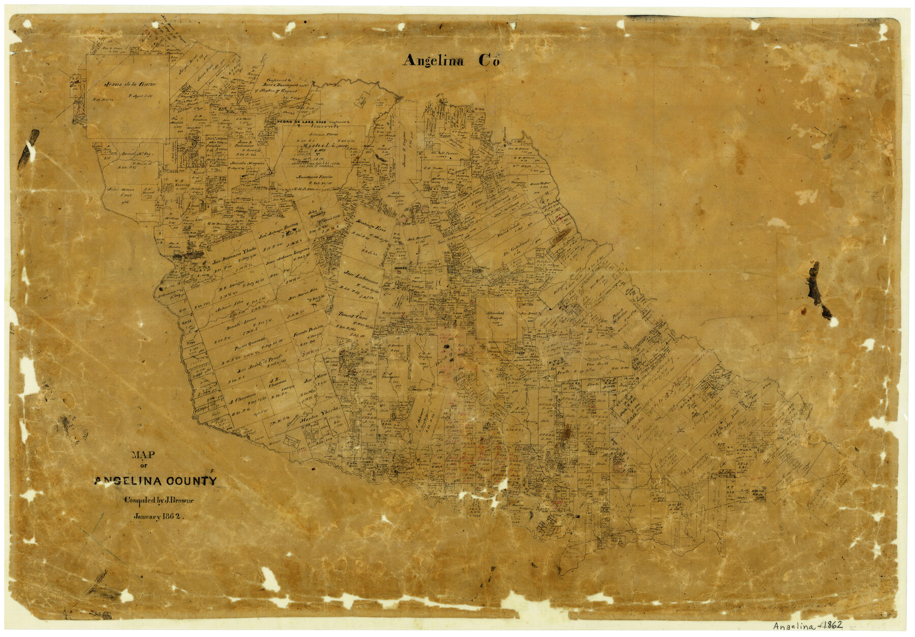
Map of Angelina County
- 
                          Map/Doc
3233
 - 
                            Collection
General Map Collection
 - 
                            Object Dates
1/1862 (Creation Date)
 - 
                            People and Organizations
J. Browne (Compiler)
 - 
                            Counties
Angelina
 - 
                            Subjects
County
 - 
                            Height x Width
19.1 x 27.0 inches
48.5 x 68.6 cm
 - 
                            Features
Neches River
Burch's Creek
Mill Creek
Cypress Creek
Chalk Creek
Baluxy [sic] Creek
Bear Creek
Brick Creek
Pophor's [sic] Creek
Homer
Johnson's Bayou
Devil's Bayou
Kerr's Creek
Stovall's Creek
Angelina River
Shawnee Creek
Stanley's Creek
Crawford's Creek
Odell's Creek
Anderson's Creek
Bodin [sic] Bayou
Procella Creek
Marion
 
Part of: General Map Collection
            Rains County Boundary File 71


                                            Print $6.00                    
                                             -                         Digital $50.00                                    
                Rains County Boundary File 71
Size 8.7 x 3.5 inches
                                Map/Doc 58094
            
            Montgomery County Sketch File 27


                                            Print $20.00                    
                                             -                         Digital $50.00                                    
                Montgomery County Sketch File 27
1932
Size 37.3 x 41.9 inches
                                Map/Doc 10548
            
            Flight Mission No. DIX-10P, Frame 65, Aransas County


                                            Print $20.00                    
                                             -                         Digital $50.00                                    
                Flight Mission No. DIX-10P, Frame 65, Aransas County
1956
Size 18.6 x 22.3 inches
                                Map/Doc 83926
            
            Lake Corpus Christi and a city map of Mathis, Texas [Verso]


            Lake Corpus Christi and a city map of Mathis, Texas [Verso]
1984
Size 29.3 x 22.9 inches
                                Map/Doc 94171
            
            Karte von Texas entworfen nach den Vermessungen welche in den Acten der General Land Office der Republic liegen bis zum Jahr 1839


                                            Print $20.00                    
                                             -                         Digital $50.00                                    
                Karte von Texas entworfen nach den Vermessungen welche in den Acten der General Land Office der Republic liegen bis zum Jahr 1839
Size 18.6 x 14.1 inches
                                Map/Doc 96629
            
            Traced from Genl. Arista's map captured by the American Army under Genl. Taylor at Resaca de la Palma 9th May '46 and presented to James K. Polk, President U. States


                                            Print $20.00                    
                                             -                         Digital $50.00                                    
                Traced from Genl. Arista's map captured by the American Army under Genl. Taylor at Resaca de la Palma 9th May '46 and presented to James K. Polk, President U. States
1846
Size 18.1 x 27.3 inches
                                Map/Doc 73062
            
            Jeff Davis County Working Sketch 33


                                            Print $40.00                    
                                             -                         Digital $50.00                                    
                Jeff Davis County Working Sketch 33
1977
Size 28.8 x 48.3 inches
                                Map/Doc 66528
            
            McCulloch County Boundary File 64


                                            Print $36.00                    
                                             -                         Digital $50.00                                    
                McCulloch County Boundary File 64
Size 9.2 x 8.9 inches
                                Map/Doc 56919
            
            Hale County Sketch File 16


                                            Print $4.00                    
                                             -                         Digital $50.00                                    
                Hale County Sketch File 16
1888
Size 12.8 x 8.2 inches
                                Map/Doc 24747
            
            Brazos Santiago, Texas


                                            Print $20.00                    
                                             -                         Digital $50.00                                    
                Brazos Santiago, Texas
1882
Size 18.3 x 26.0 inches
                                Map/Doc 72986
            
            Real County Working Sketch 85


                                            Print $5.00                    
                                             -                         Digital $50.00                                    
                Real County Working Sketch 85
1988
Size 27.0 x 30.0 inches
                                Map/Doc 71977
            
            Childress County Rolled Sketch 12


                                            Print $20.00                    
                                             -                         Digital $50.00                                    
                Childress County Rolled Sketch 12
1940
Size 44.2 x 11.3 inches
                                Map/Doc 8603
            You may also like
            Map Showing a Resurvey of Part of Blk. I, H. &. G. N. Ry. Co. Pecos County, Texas, following field notes copied from Jacob Kuechler's field book of his original survey made in October and November 1876


                                            Print $20.00                    
                                             -                         Digital $50.00                                    
                Map Showing a Resurvey of Part of Blk. I, H. &. G. N. Ry. Co. Pecos County, Texas, following field notes copied from Jacob Kuechler's field book of his original survey made in October and November 1876
1930
Size 19.2 x 14.4 inches
                                Map/Doc 91549
            
            [Leagues 575, 578, 609, and 616, Blocks T2, T3, and K13]


                                            Print $20.00                    
                                             -                         Digital $50.00                                    
                [Leagues 575, 578, 609, and 616, Blocks T2, T3, and K13]
Size 20.5 x 20.0 inches
                                Map/Doc 91053
            
            Kerr County Sketch File 8


                                            Print $4.00                    
                                             -                         Digital $50.00                                    
                Kerr County Sketch File 8
1882
Size 12.6 x 8.1 inches
                                Map/Doc 28871
            
            [Letters to and from Maj. W. J. Powell regarding surveys of Texas and Pacific Ry. Lands west of the Pecos. Blks 53-55, Township 1 & 2 map within]


                                            Print $124.00                    
                                             -                         Digital $50.00                                    
                [Letters to and from Maj. W. J. Powell regarding surveys of Texas and Pacific Ry. Lands west of the Pecos. Blks 53-55, Township 1 & 2 map within]
1934
Size 10.2 x 15.4 inches
                                Map/Doc 2249
            
            Texas with population and location of principal towns and cities according to latest reliable statistics


                                            Print $20.00                    
                                             -                         Digital $50.00                                    
                Texas with population and location of principal towns and cities according to latest reliable statistics
1912
Size 19.0 x 21.2 inches
                                Map/Doc 95877
            
            [University Blocks 17 and 18, Block Z, C4, 194, 178, A2, C3]


                                            Print $40.00                    
                                             -                         Digital $50.00                                    
                [University Blocks 17 and 18, Block Z, C4, 194, 178, A2, C3]
1882
Size 81.8 x 54.1 inches
                                Map/Doc 93199
            
            Coast Chart No. 210 Aransas Pass and Corpus Christi Bay with the coast to latitude 27° 12' Texas


                                            Print $20.00                    
                                             -                         Digital $50.00                                    
                Coast Chart No. 210 Aransas Pass and Corpus Christi Bay with the coast to latitude 27° 12' Texas
1887
Size 27.5 x 18.2 inches
                                Map/Doc 72812
            
            Working Sketch Bastrop County


                                            Print $20.00                    
                                             -                         Digital $50.00                                    
                Working Sketch Bastrop County
1923
Size 16.9 x 13.3 inches
                                Map/Doc 90146
            
            [Sketch of Surveys in Crockett County, Texas]


                                            Print $20.00                    
                                             -                         Digital $50.00                                    
                [Sketch of Surveys in Crockett County, Texas]
1880
Size 21.9 x 12.8 inches
                                Map/Doc 10778
            
            Jefferson County Rolled Sketch 49


                                            Print $40.00                    
                                             -                         Digital $50.00                                    
                Jefferson County Rolled Sketch 49
1963
Size 32.5 x 57.4 inches
                                Map/Doc 66844
            
            Map of King County


                                            Print $20.00                    
                                             -                         Digital $50.00                                    
                Map of King County
1903
Size 45.4 x 42.9 inches
                                Map/Doc 66892