Jones County Rolled Sketch 4
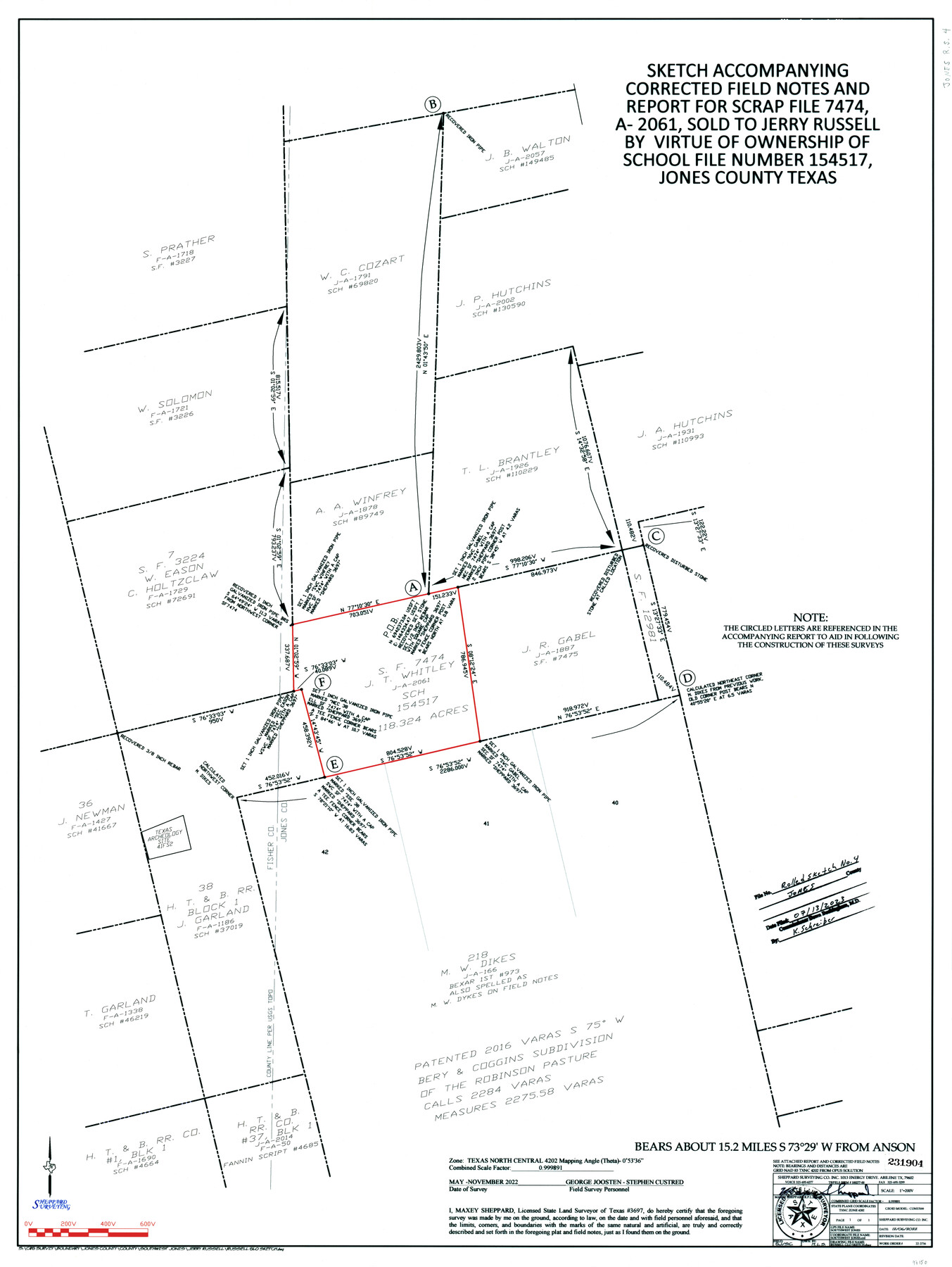
Sketch accompanying corrected field notes and report for Scrap File 7474, A-2061, sold to Jerry Russell by virtue of ownership of School File number 154517, Jones County, Texas
-
Map/Doc
97150
-
Collection
General Map Collection
-
Object Dates
12/6/2022 (Creation Date)
7/13/2023 (File Date)
-
People and Organizations
Maxey Sheppard (Surveyor/Engineer)
-
Counties
Jones Fisher
-
Subjects
Surveying Rolled Sketch
-
Height x Width
31.9 x 24.0 inches
81.0 x 61.0 cm
-
Medium
mylar, print
-
Scale
1" = 200 varas
Part of: General Map Collection
Galveston Bay Entrance - Galveston and Texas City Harbors

Print $40.00
- Digital $50.00
Galveston Bay Entrance - Galveston and Texas City Harbors
1992
Size 37.1 x 55.6 inches
Map/Doc 69866
Kimble County Working Sketch 14

Print $20.00
- Digital $50.00
Kimble County Working Sketch 14
1923
Size 17.2 x 13.2 inches
Map/Doc 70082
Anderson County Working Sketch 42

Print $40.00
- Digital $50.00
Anderson County Working Sketch 42
1987
Size 34.4 x 51.1 inches
Map/Doc 67042
North Sulphur River, Bartley Gin Sheet

Print $20.00
- Digital $50.00
North Sulphur River, Bartley Gin Sheet
1928
Size 21.1 x 42.5 inches
Map/Doc 65173
King County Sketch File 7A

Print $28.00
- Digital $50.00
King County Sketch File 7A
1902
Size 22.1 x 34.7 inches
Map/Doc 11936
Edwards County Rolled Sketch 21

Print $20.00
- Digital $50.00
Edwards County Rolled Sketch 21
1948
Size 17.0 x 29.4 inches
Map/Doc 5809
Brown County Sketch File 20

Print $10.00
- Digital $50.00
Brown County Sketch File 20
Size 6.6 x 8.3 inches
Map/Doc 16620
Map of Hill County

Print $20.00
- Digital $50.00
Map of Hill County
1882
Size 21.6 x 25.5 inches
Map/Doc 3669
Bastrop County Boundary File 1

Print $4.00
- Digital $50.00
Bastrop County Boundary File 1
Size 12.6 x 8.3 inches
Map/Doc 50313
Zapata County

Print $40.00
- Digital $50.00
Zapata County
1935
Size 56.7 x 43.2 inches
Map/Doc 63145
Wilson County Sketch File 4

Print $28.00
- Digital $50.00
Wilson County Sketch File 4
1851
Size 8.4 x 7.7 inches
Map/Doc 40404
Grayson County Working Sketch 25

Print $20.00
- Digital $50.00
Grayson County Working Sketch 25
1979
Size 34.8 x 35.0 inches
Map/Doc 63264
You may also like
Flight Mission No. CUG-3P, Frame 134, Kleberg County

Print $20.00
- Digital $50.00
Flight Mission No. CUG-3P, Frame 134, Kleberg County
1956
Size 18.5 x 22.3 inches
Map/Doc 86269
Zavala County Sketch File 44

Print $25.00
- Digital $50.00
Zavala County Sketch File 44
1915
Size 10.1 x 14.3 inches
Map/Doc 41416
Starr County Sketch File 28

Print $12.00
- Digital $50.00
Starr County Sketch File 28
1933
Size 11.2 x 8.8 inches
Map/Doc 36948
[Galveston, Harrisburg & San Antonio Railroad from Cuero to Stockdale]
![64184, [Galveston, Harrisburg & San Antonio Railroad from Cuero to Stockdale], General Map Collection](https://historictexasmaps.com/wmedia_w700/maps/64184.tif.jpg)
Print $20.00
- Digital $50.00
[Galveston, Harrisburg & San Antonio Railroad from Cuero to Stockdale]
1906
Size 14.1 x 34.2 inches
Map/Doc 64184
Kenedy County Rolled Sketch 16

Print $40.00
- Digital $50.00
Kenedy County Rolled Sketch 16
1978
Size 36.7 x 50.2 inches
Map/Doc 10693
Red River, Bois D'Arc Creek Floodway Sheet No. 7

Print $20.00
- Digital $50.00
Red River, Bois D'Arc Creek Floodway Sheet No. 7
1917
Size 29.0 x 23.8 inches
Map/Doc 69662
Robertson County Working Sketch 2

Print $20.00
- Digital $50.00
Robertson County Working Sketch 2
1939
Size 14.5 x 16.3 inches
Map/Doc 63575
Supreme Court of the United States, October Term, 1923, No. 15, Original - The State of Oklahoma, Complainant vs. The State of Texas, Defendant, The United States, Intervener; Report of the Boundary Commissioners

Print $20.00
- Digital $50.00
Supreme Court of the United States, October Term, 1923, No. 15, Original - The State of Oklahoma, Complainant vs. The State of Texas, Defendant, The United States, Intervener; Report of the Boundary Commissioners
1923
Size 34.4 x 40.6 inches
Map/Doc 75120
General Highway Map, Gregg County, Texas

Print $20.00
General Highway Map, Gregg County, Texas
1961
Size 18.1 x 24.6 inches
Map/Doc 79489
Coleman County Sketch File 42

Print $24.00
- Digital $50.00
Coleman County Sketch File 42
1891
Size 5.8 x 8.9 inches
Map/Doc 18763

Armstrong County Sketch File 5

Print $40.00
- Digital $50.00
Armstrong County Sketch File 5
1887
Size 19.7 x 22.9 inches
Map/Doc 10841