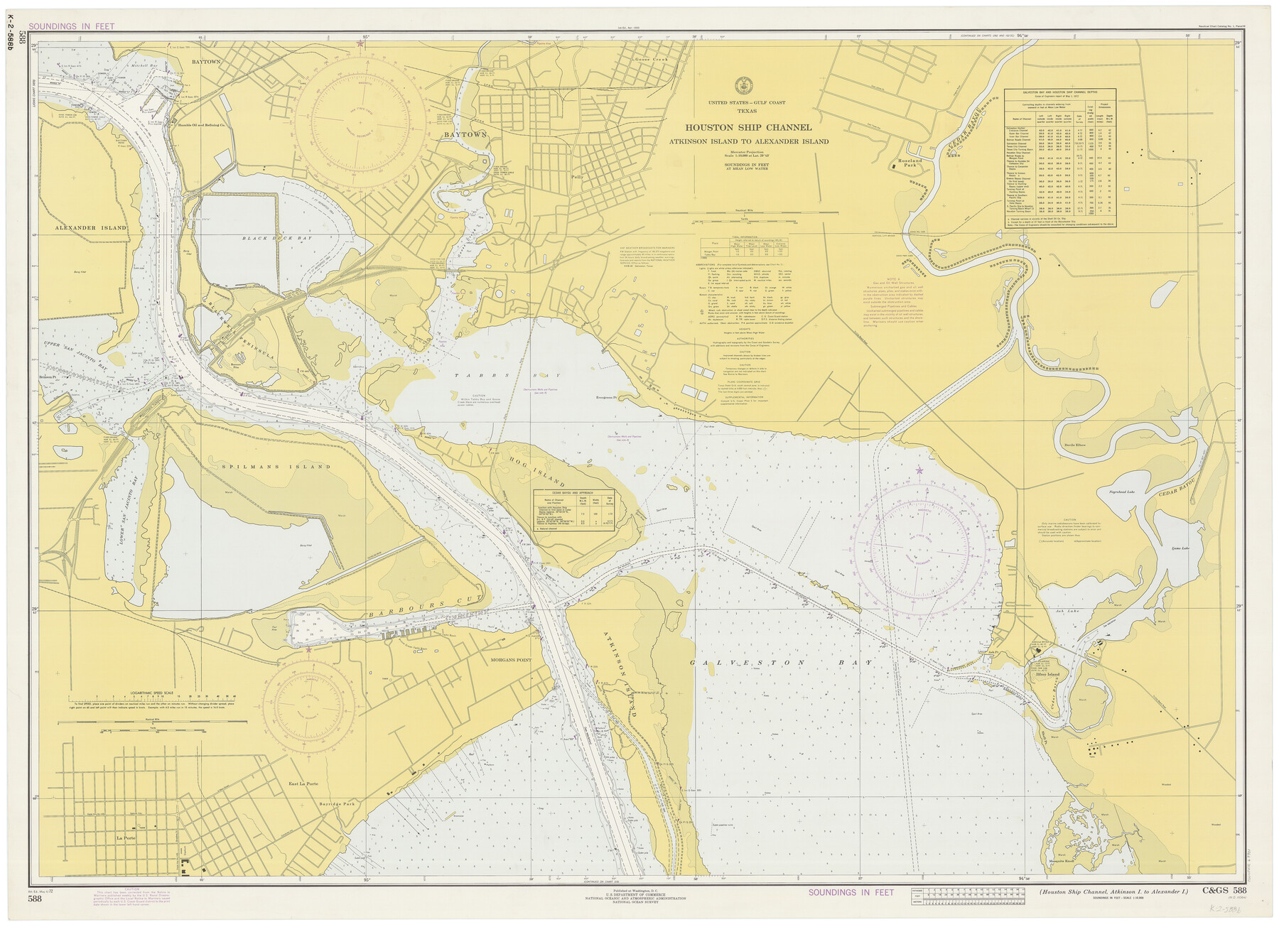
Houston Ship Channel, Atkinson Island to Alexander Island
K-2-588a
-
Map/Doc
69901
-
Collection
General Map Collection
-
Object Dates
5/6/1972 (Creation Date)
-
Counties
Harris Chambers
-
Subjects
Nautical Charts
-
Height x Width
36.9 x 50.0 inches
93.7 x 127.0 cm
Part of: General Map Collection
Orange County Working Sketch 46

Print $3.00
- Digital $50.00
Orange County Working Sketch 46
1982
Size 10.8 x 9.9 inches
Map/Doc 71378
Historia de Nueva-España, escrita por su esclarecido conquistador Hernan Cortes, aumentada con otros documentos, y notas, por el ilustrissimo señor don Francisco Antonio Lorenzana, Arzobispo de Mexico

Historia de Nueva-España, escrita por su esclarecido conquistador Hernan Cortes, aumentada con otros documentos, y notas, por el ilustrissimo señor don Francisco Antonio Lorenzana, Arzobispo de Mexico
1770
Map/Doc 97351
El Paso County Working Sketch 40

Print $20.00
- Digital $50.00
El Paso County Working Sketch 40
1992
Size 21.5 x 24.0 inches
Map/Doc 69062
Eastland County Sketch File 5

Print $4.00
- Digital $50.00
Eastland County Sketch File 5
Size 6.4 x 7.1 inches
Map/Doc 21570
Flight Mission No. BRA-16M, Frame 50, Jefferson County

Print $20.00
- Digital $50.00
Flight Mission No. BRA-16M, Frame 50, Jefferson County
1953
Size 18.5 x 22.5 inches
Map/Doc 85667
Briscoe County Sketch File G

Print $40.00
- Digital $50.00
Briscoe County Sketch File G
1918
Size 17.7 x 22.4 inches
Map/Doc 11004
State of Texas

Print $40.00
- Digital $50.00
State of Texas
1948
Size 44.6 x 56.8 inches
Map/Doc 78634
[Right of Way Map, Belton Branch of the M.K.&T. RR.]
![64220, [Right of Way Map, Belton Branch of the M.K.&T. RR.], General Map Collection](https://historictexasmaps.com/wmedia_w700/maps/64220.tif.jpg)
Print $20.00
- Digital $50.00
[Right of Way Map, Belton Branch of the M.K.&T. RR.]
1896
Size 22.2 x 7.4 inches
Map/Doc 64220
Dimmit County Boundary File 4

Print $14.00
- Digital $50.00
Dimmit County Boundary File 4
Size 14.1 x 8.8 inches
Map/Doc 52570
Val Verde County Working Sketch 98

Print $20.00
- Digital $50.00
Val Verde County Working Sketch 98
1980
Size 26.5 x 31.8 inches
Map/Doc 72233
Harris County Working Sketch 126

Print $20.00
- Digital $50.00
Harris County Working Sketch 126
1995
Size 14.5 x 30.0 inches
Map/Doc 66018
Current Miscellaneous File 41

Print $8.00
- Digital $50.00
Current Miscellaneous File 41
Size 8.2 x 10.8 inches
Map/Doc 73977
You may also like
Menard County Sketch File 26

Print $8.00
- Digital $50.00
Menard County Sketch File 26
1936
Size 8.7 x 14.3 inches
Map/Doc 31560
Parker County Sketch File 14

Print $20.00
- Digital $50.00
Parker County Sketch File 14
1853
Size 25.6 x 10.3 inches
Map/Doc 12143
McMullen County Rolled Sketch 13

Print $20.00
- Digital $50.00
McMullen County Rolled Sketch 13
1943
Size 45.8 x 29.4 inches
Map/Doc 6730
Kimble County Working Sketch 20

Print $20.00
- Digital $50.00
Kimble County Working Sketch 20
1929
Size 36.2 x 27.8 inches
Map/Doc 70088
Map of the State of Coahuila and Texas

Print $20.00
Map of the State of Coahuila and Texas
1833
Size 16.1 x 20.2 inches
Map/Doc 76246
William T. Brewster and Surrounding Surveys]
![91024, William T. Brewster and Surrounding Surveys], Twichell Survey Records](https://historictexasmaps.com/wmedia_w700/maps/91024-1.tif.jpg)
Print $20.00
- Digital $50.00
William T. Brewster and Surrounding Surveys]
Size 20.3 x 36.8 inches
Map/Doc 91024
Pecos County Rolled Sketch 174

Print $20.00
- Digital $50.00
Pecos County Rolled Sketch 174
Size 23.3 x 25.0 inches
Map/Doc 7294
Dallam County Working Sketch 2a

Print $20.00
- Digital $50.00
Dallam County Working Sketch 2a
1886
Size 17.9 x 15.9 inches
Map/Doc 78213
Stonewall County Sketch File 18

Print $16.00
- Digital $50.00
Stonewall County Sketch File 18
1902
Size 13.7 x 8.4 inches
Map/Doc 37276
Palo Pinto County Sketch File 6

Print $40.00
- Digital $50.00
Palo Pinto County Sketch File 6
1875
Size 9.3 x 18.8 inches
Map/Doc 33396
Coke County Sketch File 32

Print $8.00
- Digital $50.00
Coke County Sketch File 32
1949
Size 11.1 x 8.5 inches
Map/Doc 18645
Uvalde County Rolled Sketch 8

Print $20.00
- Digital $50.00
Uvalde County Rolled Sketch 8
Size 21.3 x 37.5 inches
Map/Doc 8093