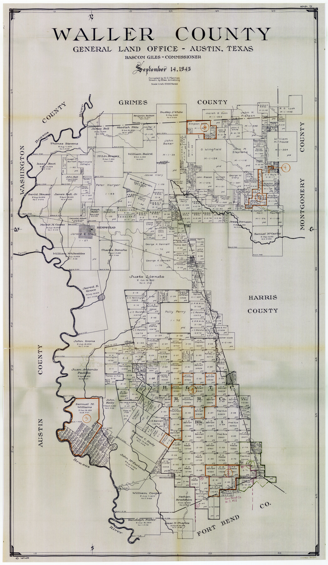
Waller County Working Sketch Graphic Index
-
Map/Doc
76730
-
Collection
General Map Collection
-
Object Dates
9/14/1945 (Creation Date)
-
People and Organizations
G.C. Morriss (Compiler)
Eltea Armstrong (Draftsman)
-
Counties
Waller
-
Subjects
County Surveying Working Sketch
-
Height x Width
46.7 x 27.2 inches
118.6 x 69.1 cm
-
Scale
1" = 2000 varas
Part of: General Map Collection
Intracoastal Waterway in Texas - Corpus Christi to Point Isabel including Arroyo Colorado to Mo. Pac. R.R. Bridge Near Harlingen

Print $20.00
- Digital $50.00
Intracoastal Waterway in Texas - Corpus Christi to Point Isabel including Arroyo Colorado to Mo. Pac. R.R. Bridge Near Harlingen
1933
Size 28.1 x 40.8 inches
Map/Doc 61847
Map of the State of Texas

Print $40.00
- Digital $50.00
Map of the State of Texas
1879
Size 102.7 x 106.6 inches
Map/Doc 16973
Angelina County Sketch File 14

Print $2.00
- Digital $50.00
Angelina County Sketch File 14
Size 7.6 x 6.9 inches
Map/Doc 12959
Jeff Davis County Working Sketch 31

Print $20.00
- Digital $50.00
Jeff Davis County Working Sketch 31
1969
Size 41.6 x 43.3 inches
Map/Doc 66526
Hopkins County Boundary File 3a

Print $4.00
- Digital $50.00
Hopkins County Boundary File 3a
Size 10.7 x 8.7 inches
Map/Doc 55082
Hamilton County Sketch File 3

Print $4.00
- Digital $50.00
Hamilton County Sketch File 3
1852
Size 12.7 x 8.0 inches
Map/Doc 24901
Jack County Working Sketch 13

Print $20.00
- Digital $50.00
Jack County Working Sketch 13
1975
Size 25.5 x 35.8 inches
Map/Doc 66439
Right of Way and Track Map - Houston & Texas Central R.R. operated by the T. and N. O. R.R. Co. - Main Line

Print $40.00
- Digital $50.00
Right of Way and Track Map - Houston & Texas Central R.R. operated by the T. and N. O. R.R. Co. - Main Line
1918
Size 26.0 x 58.1 inches
Map/Doc 82856
Galveston to Rio Grande

Print $20.00
- Digital $50.00
Galveston to Rio Grande
1941
Size 43.7 x 37.1 inches
Map/Doc 69957
Louisiana and Texas Intracoastal Waterway - Sabine River-Galveston Bay Section, Steel Sheet Pile Dyke at Galveston Bay Entrance

Print $20.00
- Digital $50.00
Louisiana and Texas Intracoastal Waterway - Sabine River-Galveston Bay Section, Steel Sheet Pile Dyke at Galveston Bay Entrance
1933
Size 31.4 x 40.9 inches
Map/Doc 61818
Ector County Rolled Sketch 10

Print $20.00
- Digital $50.00
Ector County Rolled Sketch 10
1941
Size 34.2 x 32.1 inches
Map/Doc 8838
Travis County Rolled Sketch 27

Print $20.00
- Digital $50.00
Travis County Rolled Sketch 27
1945
Size 23.5 x 17.8 inches
Map/Doc 8029
You may also like
Nueces County Working Sketch 4

Print $20.00
- Digital $50.00
Nueces County Working Sketch 4
1951
Size 46.8 x 36.2 inches
Map/Doc 71306
Bowie County Working Sketch 25

Print $20.00
- Digital $50.00
Bowie County Working Sketch 25
1977
Size 20.5 x 33.9 inches
Map/Doc 67429
Kendall County Working Sketch 15

Print $20.00
- Digital $50.00
Kendall County Working Sketch 15
1967
Size 41.4 x 40.7 inches
Map/Doc 66687
Harris County Working Sketch 35

Print $20.00
- Digital $50.00
Harris County Working Sketch 35
1938
Size 28.8 x 25.2 inches
Map/Doc 65927
Kinney County Rolled Sketch 14

Print $20.00
- Digital $50.00
Kinney County Rolled Sketch 14
1956
Size 19.5 x 25.8 inches
Map/Doc 6543
Edwards County Working Sketch 29

Print $40.00
- Digital $50.00
Edwards County Working Sketch 29
1946
Size 44.9 x 53.9 inches
Map/Doc 68905
[H. & G. N. RR. Company, Block B3]
![90718, [H. & G. N. RR. Company, Block B3], Twichell Survey Records](https://historictexasmaps.com/wmedia_w700/maps/90718-1.tif.jpg)
Print $20.00
- Digital $50.00
[H. & G. N. RR. Company, Block B3]
Size 34.9 x 28.8 inches
Map/Doc 90718
San Patricio County Sketch File 23

Print $20.00
San Patricio County Sketch File 23
1910
Size 22.9 x 12.9 inches
Map/Doc 12286
Edwards County Working Sketch 134

Print $40.00
- Digital $50.00
Edwards County Working Sketch 134
1986
Size 29.4 x 54.2 inches
Map/Doc 69010
Map of the City of Barry, John McGowan & J.B. & A. Adams Surveys, Navarro County, Texas

Print $20.00
- Digital $50.00
Map of the City of Barry, John McGowan & J.B. & A. Adams Surveys, Navarro County, Texas
1958
Size 28.4 x 25.4 inches
Map/Doc 94015
Zapata County

Print $40.00
- Digital $50.00
Zapata County
1935
Size 55.8 x 41.1 inches
Map/Doc 77467
Jefferson County

Print $20.00
- Digital $50.00
Jefferson County
1873
Size 22.9 x 19.9 inches
Map/Doc 3728