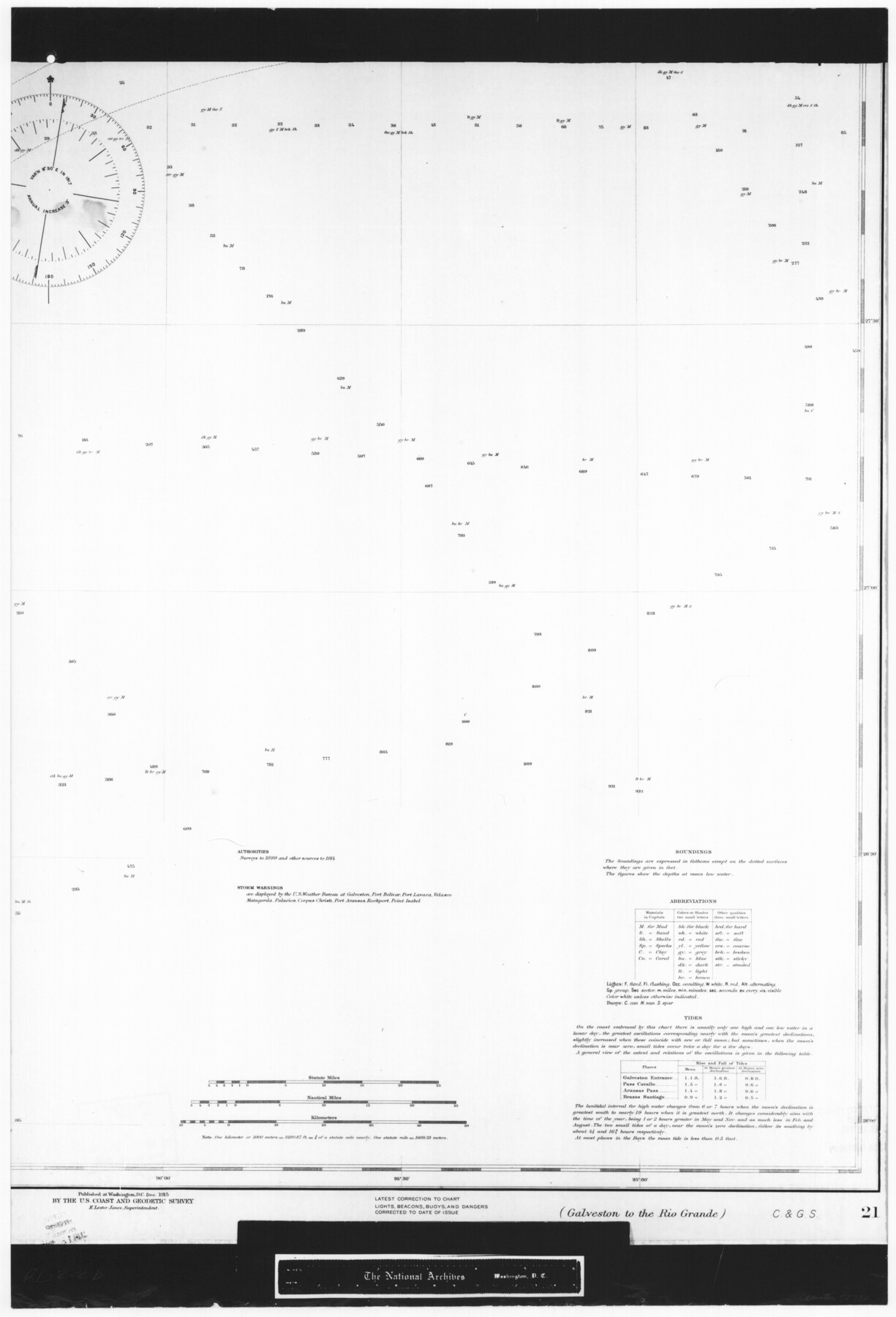
United States Gulf Coast - from Galveston to the Rio Grande
RL-2-2b
-
Map/Doc
72732
-
Collection
General Map Collection
-
Object Dates
1915 (Creation Date)
-
People and Organizations
U. S. Coast and Geodetic Survey (Publisher)
-
Subjects
Nautical Charts
-
Height x Width
26.9 x 18.3 inches
68.3 x 46.5 cm
-
Comments
B/W photostat copy from National Archives in multiple pieces.
Part of: General Map Collection
The Inca, An Empire and its Ancestors

The Inca, An Empire and its Ancestors
Size 31.2 x 20.4 inches
Map/Doc 95936
Jack County Working Sketch 14

Print $20.00
- Digital $50.00
Jack County Working Sketch 14
1981
Size 28.2 x 30.2 inches
Map/Doc 66440
Duval County Working Sketch 30

Print $20.00
- Digital $50.00
Duval County Working Sketch 30
1950
Size 29.1 x 33.5 inches
Map/Doc 68754
Dickens County Sketch File 29

Print $6.00
- Digital $50.00
Dickens County Sketch File 29
1921
Size 5.9 x 8.8 inches
Map/Doc 21016
Hartley County Sketch File 6

Print $20.00
- Digital $50.00
Hartley County Sketch File 6
Size 30.5 x 25.6 inches
Map/Doc 11698
Bailey County Sketch File 7

Print $8.00
- Digital $50.00
Bailey County Sketch File 7
1913
Size 14.0 x 8.7 inches
Map/Doc 13958
Swisher County Sketch File 19

Print $16.00
- Digital $50.00
Swisher County Sketch File 19
1913
Size 10.0 x 6.5 inches
Map/Doc 37662
McMullen County

Print $40.00
- Digital $50.00
McMullen County
1967
Size 50.8 x 35.8 inches
Map/Doc 95586
Montague County

Print $20.00
- Digital $50.00
Montague County
1924
Size 47.9 x 34.7 inches
Map/Doc 95593
Brazoria County NRC Article 33.136 Sketch 15

Print $44.00
- Digital $50.00
Brazoria County NRC Article 33.136 Sketch 15
2014
Size 39.8 x 30.0 inches
Map/Doc 94698
Lubbock County

Print $20.00
- Digital $50.00
Lubbock County
1879
Size 23.8 x 21.7 inches
Map/Doc 3829
Right of Way and Track Map of The Wichita Falls & Southern Railroad Company

Print $40.00
- Digital $50.00
Right of Way and Track Map of The Wichita Falls & Southern Railroad Company
1942
Size 24.6 x 56.1 inches
Map/Doc 64516
You may also like
Reagan County Rolled Sketch 16

Print $20.00
- Digital $50.00
Reagan County Rolled Sketch 16
Size 25.6 x 47.5 inches
Map/Doc 9811
Carson County Working Sketch 4

Print $20.00
- Digital $50.00
Carson County Working Sketch 4
1952
Size 26.1 x 37.0 inches
Map/Doc 67875
Foard County Sketch File 14

Print $4.00
- Digital $50.00
Foard County Sketch File 14
1885
Size 14.4 x 8.8 inches
Map/Doc 22819
Montgomery County

Print $20.00
- Digital $50.00
Montgomery County
1895
Size 21.6 x 24.8 inches
Map/Doc 3897
Reeves County Sketch File 23a and 23b

Print $4.00
- Digital $50.00
Reeves County Sketch File 23a and 23b
1985
Size 14.9 x 8.7 inches
Map/Doc 35222
Flight Mission No. BRA-7M, Frame 124, Jefferson County

Print $20.00
- Digital $50.00
Flight Mission No. BRA-7M, Frame 124, Jefferson County
1953
Size 16.2 x 16.1 inches
Map/Doc 85518
Flight Mission No. DQN-3K, Frame 52, Calhoun County

Print $20.00
- Digital $50.00
Flight Mission No. DQN-3K, Frame 52, Calhoun County
1953
Size 18.4 x 22.2 inches
Map/Doc 84353
Winkler County Rolled Sketch 18

Print $20.00
- Digital $50.00
Winkler County Rolled Sketch 18
2017
Size 37.4 x 29.4 inches
Map/Doc 95289
Lipscomb County Boundary File 9

Print $8.00
- Digital $50.00
Lipscomb County Boundary File 9
Size 11.2 x 8.5 inches
Map/Doc 56335
Nueces County Sketch File 12c

Print $11.00
- Digital $50.00
Nueces County Sketch File 12c
1889
Size 12.6 x 8.2 inches
Map/Doc 32534
Flight Mission No. BQR-5K, Frame 73, Brazoria County

Print $20.00
- Digital $50.00
Flight Mission No. BQR-5K, Frame 73, Brazoria County
1952
Size 19.1 x 22.6 inches
Map/Doc 84018
Map of Texas from the most recent authorities

Print $20.00
- Digital $50.00
Map of Texas from the most recent authorities
1845
Map/Doc 93945