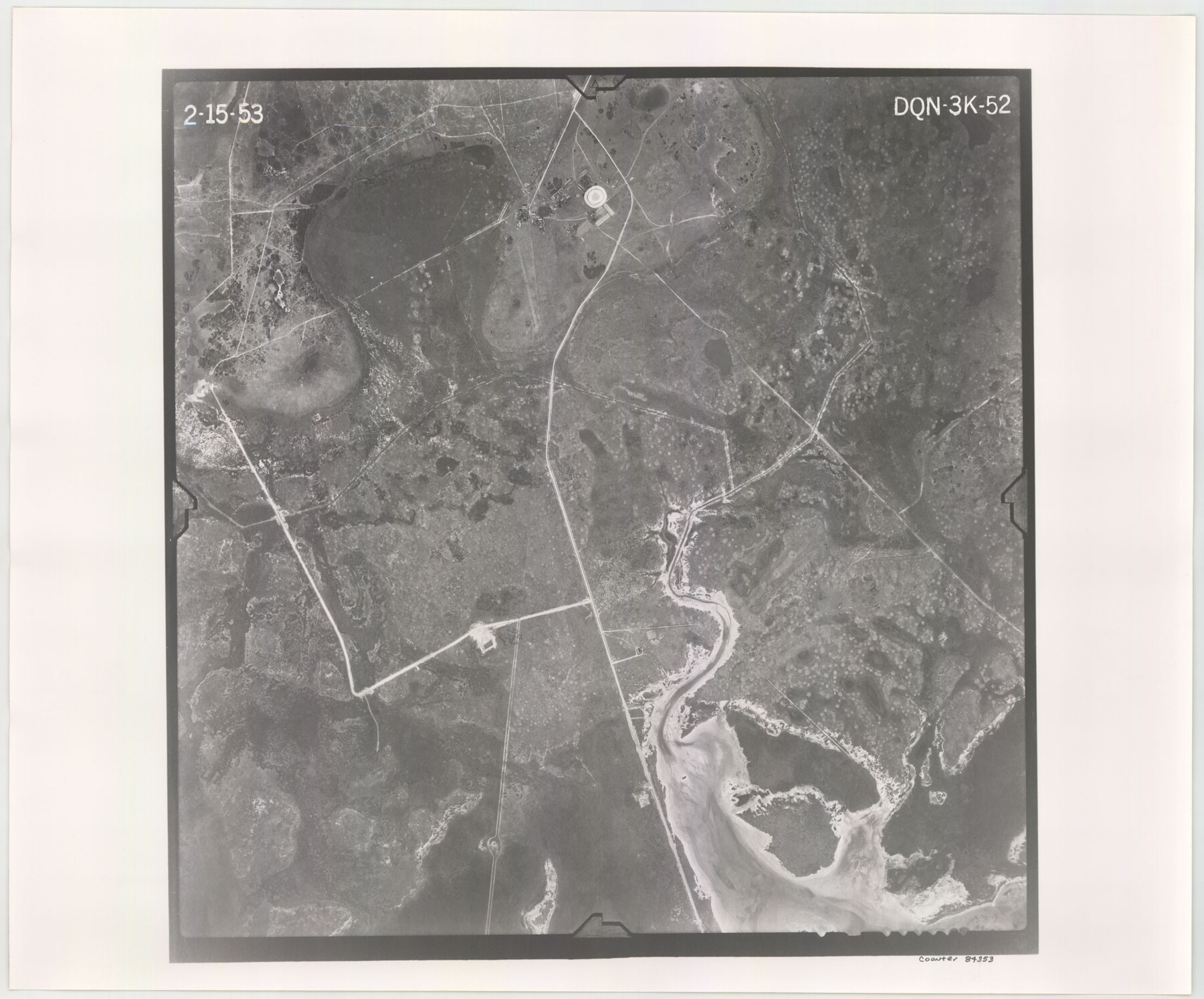
Flight Mission No. DQN-3K, Frame 52, Calhoun County
DQN-3K-52
-
Map/Doc
84353
-
Collection
General Map Collection
-
Object Dates
1953/2/15 (Creation Date)
-
People and Organizations
U. S. Department of Agriculture (Publisher)
-
Counties
Calhoun
-
Subjects
Aerial Photograph
-
Height x Width
18.4 x 22.2 inches
46.7 x 56.4 cm
-
Comments
Flown by Aero Exploration Company of Tulsa, Oklahoma.
Part of: General Map Collection
Sutton County Boundary File 4

Print $20.00
- Digital $50.00
Sutton County Boundary File 4
Size 14.2 x 8.8 inches
Map/Doc 59035
Calhoun County Rolled Sketch 30

Print $20.00
- Digital $50.00
Calhoun County Rolled Sketch 30
1974
Size 18.8 x 27.6 inches
Map/Doc 5494
Concho County Rolled Sketch 5

Print $20.00
- Digital $50.00
Concho County Rolled Sketch 5
1950
Size 41.9 x 27.6 inches
Map/Doc 5545
Eastland County Working Sketch 45

Print $20.00
- Digital $50.00
Eastland County Working Sketch 45
1979
Size 31.3 x 43.7 inches
Map/Doc 68826
Flight Mission No. BQR-22K, Frame 45, Brazoria County

Print $20.00
- Digital $50.00
Flight Mission No. BQR-22K, Frame 45, Brazoria County
1953
Size 18.7 x 22.4 inches
Map/Doc 84129
Eastland County Working Sketch 22

Print $20.00
- Digital $50.00
Eastland County Working Sketch 22
1920
Size 19.9 x 19.2 inches
Map/Doc 68803
Presidio County Boundary File 5

Print $8.00
- Digital $50.00
Presidio County Boundary File 5
Size 10.3 x 8.2 inches
Map/Doc 58087
Lee County Working Sketch 2

Print $20.00
- Digital $50.00
Lee County Working Sketch 2
1945
Size 17.8 x 19.5 inches
Map/Doc 70381
Bosque County Working Sketch 2

Print $20.00
- Digital $50.00
Bosque County Working Sketch 2
Size 19.7 x 19.6 inches
Map/Doc 67435
Hudspeth County Working Sketch 20

Print $40.00
- Digital $50.00
Hudspeth County Working Sketch 20
1966
Size 43.8 x 63.6 inches
Map/Doc 66302
Flight Mission No. BRE-5P, Frame 192, Nueces County

Print $20.00
- Digital $50.00
Flight Mission No. BRE-5P, Frame 192, Nueces County
1956
Size 18.4 x 22.3 inches
Map/Doc 86838
Hunt County Rolled Sketch 5

Print $20.00
- Digital $50.00
Hunt County Rolled Sketch 5
1956
Size 28.6 x 24.3 inches
Map/Doc 6268
You may also like
Swisher County Sketch File 11

Print $58.00
- Digital $50.00
Swisher County Sketch File 11
1917
Size 9.1 x 8.3 inches
Map/Doc 37633
Brewster County Working Sketch 68

Print $20.00
- Digital $50.00
Brewster County Working Sketch 68
1958
Size 23.3 x 22.6 inches
Map/Doc 67669
Burnet County Sketch File 28

Print $8.00
- Digital $50.00
Burnet County Sketch File 28
1874
Size 12.8 x 8.5 inches
Map/Doc 16740
Erath County Sketch File 5

Print $8.00
- Digital $50.00
Erath County Sketch File 5
Size 13.0 x 8.4 inches
Map/Doc 22263
Bandera County Sketch File 37

Print $24.00
Bandera County Sketch File 37
Size 11.0 x 8.5 inches
Map/Doc 97248
Red River County Sketch File 18

Print $2.00
- Digital $50.00
Red River County Sketch File 18
Size 5.5 x 7.9 inches
Map/Doc 35149
A New Map of Texas with the Contiguous American & Mexican States

Print $20.00
- Digital $50.00
A New Map of Texas with the Contiguous American & Mexican States
1837
Size 12.5 x 15.1 inches
Map/Doc 96643
[Surveys along the Red River, Bois d'Arc Creek, Duck Creek, and Choctaw Bayou made under G.W. Smyth, Commissioner]
![74, [Surveys along the Red River, Bois d'Arc Creek, Duck Creek, and Choctaw Bayou made under G.W. Smyth, Commissioner], General Map Collection](https://historictexasmaps.com/wmedia_w700/maps/74.tif.jpg)
Print $20.00
- Digital $50.00
[Surveys along the Red River, Bois d'Arc Creek, Duck Creek, and Choctaw Bayou made under G.W. Smyth, Commissioner]
1834
Size 19.7 x 16.0 inches
Map/Doc 74
Little River, Cameron Sheet

Print $4.00
- Digital $50.00
Little River, Cameron Sheet
1914
Size 28.3 x 24.4 inches
Map/Doc 65062
(A No. 2) Preliminary Sketch Showing the positions of Davis's South Shoal and other Dangers recently discovered by the Coast Survey and the soundings on the Old South Shoal, Bass Rip, Old Man, Pochick Rip &c.

Print $20.00
- Digital $50.00
(A No. 2) Preliminary Sketch Showing the positions of Davis's South Shoal and other Dangers recently discovered by the Coast Survey and the soundings on the Old South Shoal, Bass Rip, Old Man, Pochick Rip &c.
1846
Size 19.7 x 21.8 inches
Map/Doc 97203
Stonewall County Rolled Sketch 14

Print $20.00
- Digital $50.00
Stonewall County Rolled Sketch 14
1902
Size 32.9 x 25.2 inches
Map/Doc 7869
Ownership Map of McCulloch County, Texas

Print $20.00
- Digital $50.00
Ownership Map of McCulloch County, Texas
1951
Size 40.5 x 32.5 inches
Map/Doc 3138