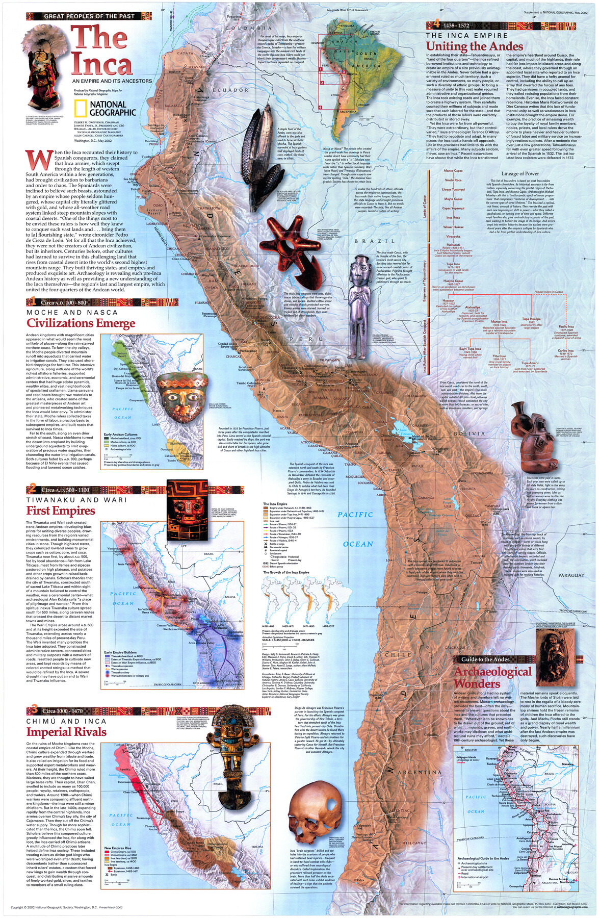
The Inca, An Empire and its Ancestors
-
Map/Doc
95936
-
Collection
General Map Collection
-
Object Dates
2002 (Publication Date)
-
People and Organizations
National Geographic Society (Publisher)
Mark Lambert (Donor)
-
Height x Width
31.2 x 20.4 inches
79.3 x 51.8 cm
-
Medium
paper, print
-
Comments
For research only. Donated by Mark Lambert in August, 2020. See 95935 for recto.
Related maps
The Inca, Machu Picchu Salutes the Sun

The Inca, Machu Picchu Salutes the Sun
Size 20.4 x 31.3 inches
Map/Doc 95935
Part of: General Map Collection
Young County Sketch File 10

Print $20.00
- Digital $50.00
Young County Sketch File 10
Size 14.1 x 17.7 inches
Map/Doc 12711
Flight Mission No. DIX-7P, Frame 88, Aransas County

Print $20.00
- Digital $50.00
Flight Mission No. DIX-7P, Frame 88, Aransas County
1956
Size 18.7 x 22.3 inches
Map/Doc 83882
Pecos County Working Sketch 22

Print $20.00
- Digital $50.00
Pecos County Working Sketch 22
1926
Size 14.3 x 23.5 inches
Map/Doc 71492
Bee County Sketch File 1

Print $4.00
- Digital $50.00
Bee County Sketch File 1
Size 8.0 x 9.5 inches
Map/Doc 14257
Edwards County Working Sketch 68

Print $20.00
- Digital $50.00
Edwards County Working Sketch 68
1957
Size 28.7 x 26.8 inches
Map/Doc 68944
University Land Field Notes for Block 52 in Crockett, Irion, and Schleicher Counties, Blocks 55 and 56 in Crockett and Schleicher Counties, Block 53 in Irion and Schleicher Counties, and Blocks 54 and 57 in Schleicher County

University Land Field Notes for Block 52 in Crockett, Irion, and Schleicher Counties, Blocks 55 and 56 in Crockett and Schleicher Counties, Block 53 in Irion and Schleicher Counties, and Blocks 54 and 57 in Schleicher County
Map/Doc 81719
Delta County Working Sketch Graphic Index

Print $20.00
- Digital $50.00
Delta County Working Sketch Graphic Index
1942
Size 25.3 x 39.2 inches
Map/Doc 76520
Matagorda County Sketch File 13

Print $20.00
- Digital $50.00
Matagorda County Sketch File 13
1902
Size 21.5 x 19.0 inches
Map/Doc 12039
Flight Mission No. DCL-7C, Frame 59, Kenedy County

Print $20.00
- Digital $50.00
Flight Mission No. DCL-7C, Frame 59, Kenedy County
1943
Size 15.4 x 15.2 inches
Map/Doc 86047
Old Miscellaneous File 5

Print $4.00
- Digital $50.00
Old Miscellaneous File 5
1846
Size 4.8 x 7.6 inches
Map/Doc 75418
Carson County Working Sketch Graphic Index

Print $20.00
- Digital $50.00
Carson County Working Sketch Graphic Index
1932
Size 41.3 x 37.9 inches
Map/Doc 76488
Franklin County Sketch File 9

Print $20.00
- Digital $50.00
Franklin County Sketch File 9
Size 13.6 x 23.1 inches
Map/Doc 11515
You may also like
Real County Working Sketch 19

Print $3.00
- Digital $50.00
Real County Working Sketch 19
1944
Size 12.0 x 10.4 inches
Map/Doc 71911
Presidio County Rolled Sketch 100

Print $20.00
- Digital $50.00
Presidio County Rolled Sketch 100
1954
Size 30.4 x 30.2 inches
Map/Doc 7382
Coleman County Sketch File 25

Print $40.00
- Digital $50.00
Coleman County Sketch File 25
1872
Size 12.5 x 15.8 inches
Map/Doc 18710
Harris County Rolled Sketch WHW

Print $20.00
- Digital $50.00
Harris County Rolled Sketch WHW
1930
Size 20.7 x 41.6 inches
Map/Doc 6466
Map of Parker County

Print $20.00
- Digital $50.00
Map of Parker County
1860
Size 24.1 x 19.0 inches
Map/Doc 3945
[Sketch of Blocks M-19, 21W, JAD, 9 and G. & M. Block 5]
![91736, [Sketch of Blocks M-19, 21W, JAD, 9 and G. & M. Block 5], Twichell Survey Records](https://historictexasmaps.com/wmedia_w700/maps/91736-1.tif.jpg)
Print $20.00
- Digital $50.00
[Sketch of Blocks M-19, 21W, JAD, 9 and G. & M. Block 5]
Size 34.0 x 25.9 inches
Map/Doc 91736
Map Showing Showing San Antonio & Aransas Pass Railway from San Antonio to Wilson County Line

Print $40.00
- Digital $50.00
Map Showing Showing San Antonio & Aransas Pass Railway from San Antonio to Wilson County Line
Size 25.8 x 101.6 inches
Map/Doc 64283
Travis County Rolled Sketch 29

Print $20.00
- Digital $50.00
Travis County Rolled Sketch 29
1946
Size 25.1 x 37.8 inches
Map/Doc 8031
Hudspeth County Working Sketch 11

Print $20.00
- Digital $50.00
Hudspeth County Working Sketch 11
1946
Size 32.1 x 36.2 inches
Map/Doc 66292
Matagorda Bay Including Lavaca and Tres Palacios Bays

Print $40.00
- Digital $50.00
Matagorda Bay Including Lavaca and Tres Palacios Bays
1973
Size 37.0 x 48.4 inches
Map/Doc 73363
Flight Mission No. DAG-21K, Frame 105, Matagorda County

Print $20.00
- Digital $50.00
Flight Mission No. DAG-21K, Frame 105, Matagorda County
1952
Size 16.5 x 16.5 inches
Map/Doc 86433
Culberson County Sketch File 26

Print $8.00
- Digital $50.00
Culberson County Sketch File 26
1949
Size 11.2 x 8.8 inches
Map/Doc 20262