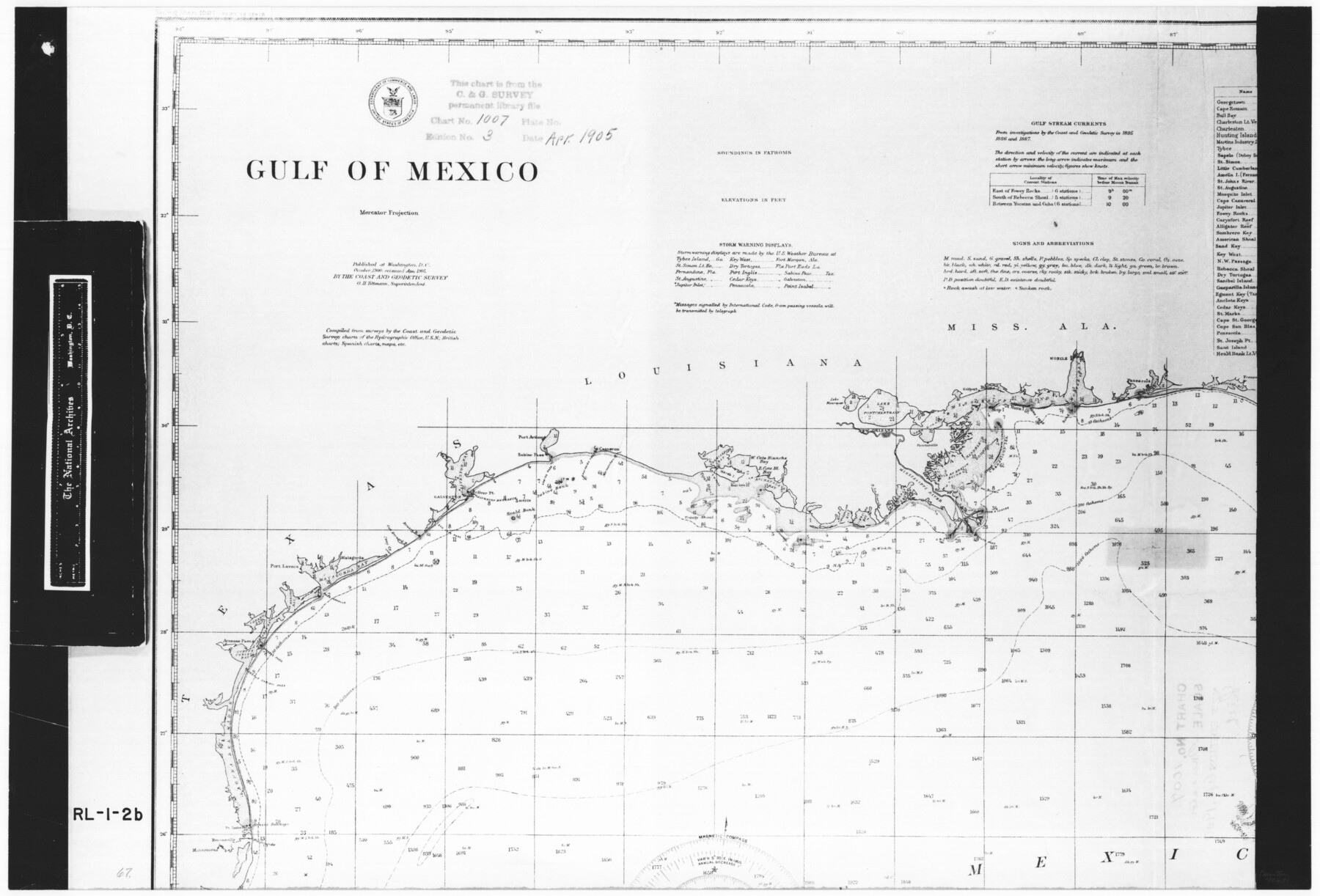
Gulf of Mexico
RL-1-2b
-
Map/Doc
72651
-
Collection
General Map Collection
-
Object Dates
1905 (Creation Date)
-
People and Organizations
Coast and Geodetic Survey (Publisher)
Coast and Geodetic Survey (Compiler)
-
Subjects
Gulf of Mexico Nautical Charts
-
Height x Width
18.2 x 26.8 inches
46.2 x 68.1 cm
-
Comments
B/W photostat copy from National Archives in multiple pieces. Chart No. 1007, Edition 3, April 1905
Part of: General Map Collection
Old Miscellaneous File 29

Print $4.00
- Digital $50.00
Old Miscellaneous File 29
1838
Size 7.4 x 12.5 inches
Map/Doc 75738
Angelina County Sketch File 8

Print $22.00
- Digital $50.00
Angelina County Sketch File 8
1858
Size 8.0 x 3.5 inches
Map/Doc 12935
Shelby County Working Sketch 28

Print $20.00
- Digital $50.00
Shelby County Working Sketch 28
2000
Size 28.8 x 29.8 inches
Map/Doc 63882
Houston County Working Sketch 3

Print $20.00
- Digital $50.00
Houston County Working Sketch 3
Size 16.7 x 18.5 inches
Map/Doc 66233
Flight Mission No. DAG-28K, Frame 29, Matagorda County

Print $20.00
- Digital $50.00
Flight Mission No. DAG-28K, Frame 29, Matagorda County
1953
Size 16.2 x 16.1 inches
Map/Doc 86597
Galveston County Rolled Sketch DB

Print $20.00
- Digital $50.00
Galveston County Rolled Sketch DB
Size 37.0 x 47.5 inches
Map/Doc 9854
Sterling County Sketch File 23

Print $10.00
- Digital $50.00
Sterling County Sketch File 23
1955
Size 11.2 x 8.8 inches
Map/Doc 37184
Flight Mission No. DCL-6C, Frame 72, Kenedy County

Print $20.00
- Digital $50.00
Flight Mission No. DCL-6C, Frame 72, Kenedy County
1943
Size 18.6 x 22.3 inches
Map/Doc 85914
Bowie County Rolled Sketch 3

Print $57.00
- Digital $50.00
Bowie County Rolled Sketch 3
1970
Size 10.0 x 15.3 inches
Map/Doc 42739

Upton County Working Sketch 54

Print $20.00
- Digital $50.00
Upton County Working Sketch 54
1983
Size 23.2 x 37.7 inches
Map/Doc 69551
Platter Quadrangle

Print $20.00
- Digital $50.00
Platter Quadrangle
1999
Size 35.4 x 23.4 inches
Map/Doc 97365
You may also like
Hardin County Sketch File 55

Print $40.00
- Digital $50.00
Hardin County Sketch File 55
1924
Size 14.2 x 13.3 inches
Map/Doc 25220
[Leagues 464-467 and vicinity]
![91649, [Leagues 464-467 and vicinity], Twichell Survey Records](https://historictexasmaps.com/wmedia_w700/maps/91649-1.tif.jpg)
Print $2.00
- Digital $50.00
[Leagues 464-467 and vicinity]
Size 10.6 x 8.1 inches
Map/Doc 91649
Concho, San Saba & Llano Valley Railway, Sterling City Branch, Texas. Right of Way and Track Map

Print $40.00
- Digital $50.00
Concho, San Saba & Llano Valley Railway, Sterling City Branch, Texas. Right of Way and Track Map
1910
Size 17.9 x 120.8 inches
Map/Doc 64436
Potter County Sketch File 10

Print $40.00
- Digital $50.00
Potter County Sketch File 10
Size 58.9 x 37.7 inches
Map/Doc 10576
Amended Map of Wildorado Situated in Oldham County, Texas on Sections 14 & 15 Block Z3

Print $20.00
- Digital $50.00
Amended Map of Wildorado Situated in Oldham County, Texas on Sections 14 & 15 Block Z3
Size 14.9 x 18.4 inches
Map/Doc 92095
Medina County Working Sketch 7

Print $20.00
- Digital $50.00
Medina County Working Sketch 7
1952
Size 26.3 x 28.5 inches
Map/Doc 70922
Lynn County Sketch File 14

Print $12.00
- Digital $50.00
Lynn County Sketch File 14
1916
Size 14.1 x 8.7 inches
Map/Doc 30491
Williamson County Working Sketch 4

Print $20.00
- Digital $50.00
Williamson County Working Sketch 4
1919
Size 23.7 x 19.4 inches
Map/Doc 72564
Jim Wells County Working Sketch 13

Print $20.00
- Digital $50.00
Jim Wells County Working Sketch 13
1980
Size 36.7 x 26.3 inches
Map/Doc 66611
Uvalde County Sketch File 26-1

Print $6.00
- Digital $50.00
Uvalde County Sketch File 26-1
1930
Size 11.5 x 8.9 inches
Map/Doc 39013
Presidio County Working Sketch 52

Print $20.00
- Digital $50.00
Presidio County Working Sketch 52
1954
Size 46.5 x 27.6 inches
Map/Doc 71729
Live Oak County Sketch File 14

Print $4.00
- Digital $50.00
Live Oak County Sketch File 14
1882
Size 13.3 x 8.8 inches
Map/Doc 30278