Old Miscellaneous File 29
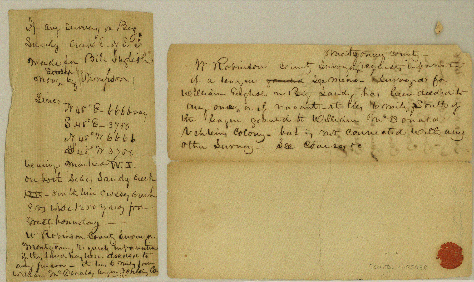
Note requesting information on a league surveyed for William Smith on Big Sandy Creek
-
Map/Doc
75738
-
Collection
General Map Collection
-
Object Dates
1838 (Creation Date)
1985/2/8 (File Date)
-
Height x Width
7.4 x 12.5 inches
18.8 x 31.8 cm
Part of: General Map Collection
Hartley County Working Sketch Graphic Index

Print $40.00
- Digital $50.00
Hartley County Working Sketch Graphic Index
1925
Size 41.0 x 50.0 inches
Map/Doc 76571
Kendall County Sketch File 9

Print $6.00
- Digital $50.00
Kendall County Sketch File 9
1879
Size 4.6 x 9.3 inches
Map/Doc 28692
Live Oak County Working Sketch Graphic Index

Print $40.00
- Digital $50.00
Live Oak County Working Sketch Graphic Index
1947
Size 53.7 x 39.4 inches
Map/Doc 76623
Sutton County Rolled Sketch 54

Print $20.00
- Digital $50.00
Sutton County Rolled Sketch 54
Size 32.4 x 27.7 inches
Map/Doc 7894
Jasper County Sketch File 32

Print $20.00
- Digital $50.00
Jasper County Sketch File 32
1906
Size 28.0 x 22.3 inches
Map/Doc 11853
[Location Survey of the Southern Kansas Railway, Kiowa Extension from a point in Drake's Location, in Indian Territory 100 miles from south line of Kansas, continuing up Wolf Creek and South Canadian River to Cottonwood Creek in Hutchinson County]
![88845, [Location Survey of the Southern Kansas Railway, Kiowa Extension from a point in Drake's Location, in Indian Territory 100 miles from south line of Kansas, continuing up Wolf Creek and South Canadian River to Cottonwood Creek in Hutchinson County], General Map Collection](https://historictexasmaps.com/wmedia_w700/maps/88845.tif.jpg)
Print $20.00
- Digital $50.00
[Location Survey of the Southern Kansas Railway, Kiowa Extension from a point in Drake's Location, in Indian Territory 100 miles from south line of Kansas, continuing up Wolf Creek and South Canadian River to Cottonwood Creek in Hutchinson County]
1886
Size 37.5 x 36.0 inches
Map/Doc 88845

Upton County Sketch File 32

Print $20.00
- Digital $50.00
Upton County Sketch File 32
1938
Size 14.9 x 24.0 inches
Map/Doc 12523
Matagorda County Working Sketch 28

Print $3.00
- Digital $50.00
Matagorda County Working Sketch 28
1980
Size 10.7 x 12.1 inches
Map/Doc 70886
Van Zandt County Sketch File 47

Print $7.00
- Digital $50.00
Van Zandt County Sketch File 47
Size 10.0 x 8.1 inches
Map/Doc 39504
Karnes County Sketch File 5

Print $7.00
- Digital $50.00
Karnes County Sketch File 5
1849
Size 8.1 x 10.0 inches
Map/Doc 28554
Wood County Working Sketch 6

Print $20.00
- Digital $50.00
Wood County Working Sketch 6
1941
Size 29.9 x 17.5 inches
Map/Doc 62006
You may also like
Aransas County Sketch File 16

Print $40.00
- Digital $50.00
Aransas County Sketch File 16
1877
Size 16.4 x 12.8 inches
Map/Doc 13147
Index to the following sixteen sheets, being a compleat chart of the West Indies with letters in the margin to direct the placing of the different sheets in their proper places

Print $20.00
- Digital $50.00
Index to the following sixteen sheets, being a compleat chart of the West Indies with letters in the margin to direct the placing of the different sheets in their proper places
1792
Size 21.5 x 28.6 inches
Map/Doc 96440
G. T. Oliver's Subdivisions of the Motley and Foard County School Leagues situated in Bailey Co., Texas

Print $20.00
- Digital $50.00
G. T. Oliver's Subdivisions of the Motley and Foard County School Leagues situated in Bailey Co., Texas
1909
Size 24.5 x 37.3 inches
Map/Doc 90181
Bee County Sketch File 3a

Print $8.00
- Digital $50.00
Bee County Sketch File 3a
1875
Size 12.7 x 8.2 inches
Map/Doc 14264
Andrews County Boundary File 1

Print $133.00
- Digital $50.00
Andrews County Boundary File 1
Size 14.6 x 9.0 inches
Map/Doc 49664
[Block D, John H. Gibson]
![92003, [Block D, John H. Gibson], Twichell Survey Records](https://historictexasmaps.com/wmedia_w700/maps/92003-1.tif.jpg)
Print $20.00
- Digital $50.00
[Block D, John H. Gibson]
Size 33.2 x 18.4 inches
Map/Doc 92003
Presidio County Sketch File 34

Print $4.00
- Digital $50.00
Presidio County Sketch File 34
1891
Size 14.3 x 8.7 inches
Map/Doc 34484
Harris County Historic Topographic 16

Print $20.00
- Digital $50.00
Harris County Historic Topographic 16
1916
Size 29.3 x 22.9 inches
Map/Doc 65826
Jefferson County Rolled Sketch 51

Print $20.00
- Digital $50.00
Jefferson County Rolled Sketch 51
1965
Size 39.1 x 38.0 inches
Map/Doc 9307
Treaty to Resolve Pending Boundary Differences and Maintain the Rio Grande and Colorado River as the International Boundary Between the United States of American and Mexico

Print $20.00
- Digital $50.00
Treaty to Resolve Pending Boundary Differences and Maintain the Rio Grande and Colorado River as the International Boundary Between the United States of American and Mexico
1970
Size 10.8 x 29.8 inches
Map/Doc 83106
Whitehead Second Addition, City of Lubbock

Print $20.00
- Digital $50.00
Whitehead Second Addition, City of Lubbock
1951
Size 14.1 x 24.0 inches
Map/Doc 92778
Bandera County Working Sketch 41

Print $20.00
- Digital $50.00
Bandera County Working Sketch 41
1977
Size 31.3 x 37.7 inches
Map/Doc 67637