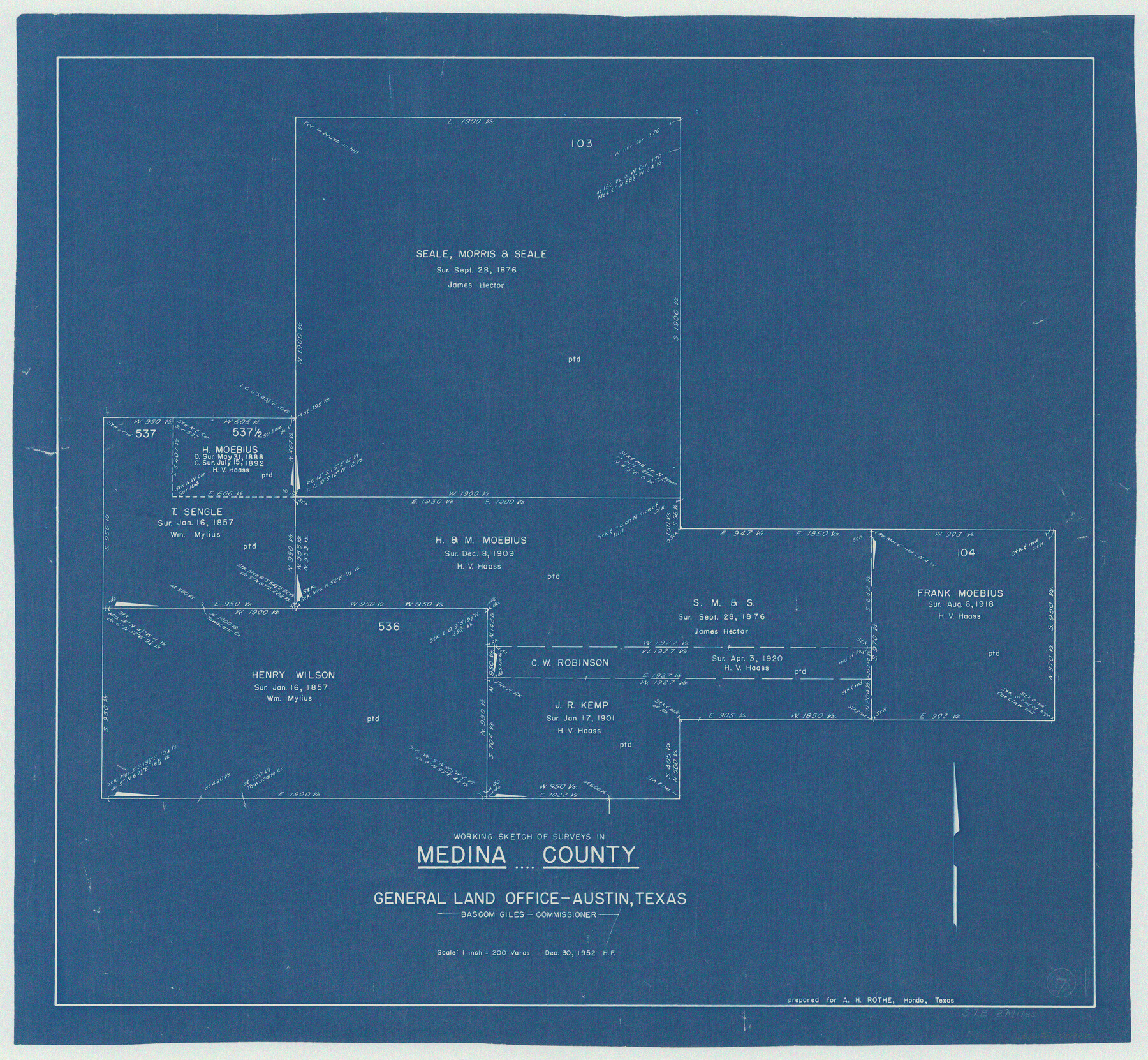
Medina County Working Sketch 7
-
Map/Doc
70922
-
Collection
General Map Collection
-
Object Dates
12/30/1952 (Creation Date)
-
People and Organizations
Herman Forbes (Draftsman)
-
Counties
Medina
-
Subjects
Surveying Working Sketch
-
Height x Width
26.3 x 28.5 inches
66.8 x 72.4 cm
-
Scale
1" = 200 varas
Part of: General Map Collection
Refugio County Working Sketch 12

Print $40.00
- Digital $50.00
Refugio County Working Sketch 12
1949
Size 42.6 x 48.2 inches
Map/Doc 63521
Controlled Mosaic by Jack Amman Photogrammetric Engineers, Inc - Sheet 27

Print $20.00
- Digital $50.00
Controlled Mosaic by Jack Amman Photogrammetric Engineers, Inc - Sheet 27
1954
Size 20.0 x 24.0 inches
Map/Doc 83478
Sabine River, East Extension Merrill Lake Sheet

Print $4.00
- Digital $50.00
Sabine River, East Extension Merrill Lake Sheet
1933
Size 24.5 x 15.1 inches
Map/Doc 65141
Matagorda County Rolled Sketch 32

Print $20.00
- Digital $50.00
Matagorda County Rolled Sketch 32
Size 29.7 x 34.9 inches
Map/Doc 6694
Panorama of the seat of war - Birds eye view of Texas and part of Mexico

Print $20.00
- Digital $50.00
Panorama of the seat of war - Birds eye view of Texas and part of Mexico
1861
Size 24.4 x 31.5 inches
Map/Doc 97250
Burnet County Boundary File 7

Print $36.00
- Digital $50.00
Burnet County Boundary File 7
Size 14.0 x 8.5 inches
Map/Doc 50893

Rucker's Work on Upper Red River

Print $20.00
- Digital $50.00
Rucker's Work on Upper Red River
1857
Size 39.3 x 26.2 inches
Map/Doc 3220
Loving County

Print $20.00
- Digital $50.00
Loving County
1932
Size 32.4 x 44.0 inches
Map/Doc 77358
San Jacinto County Working Sketch 19

Print $20.00
- Digital $50.00
San Jacinto County Working Sketch 19
1939
Size 25.4 x 25.2 inches
Map/Doc 63732
Township 1 South Range 12 West, South Western District, Louisiana

Print $20.00
- Digital $50.00
Township 1 South Range 12 West, South Western District, Louisiana
1884
Size 19.5 x 24.7 inches
Map/Doc 65880
Val Verde County Working Sketch 74

Print $20.00
- Digital $50.00
Val Verde County Working Sketch 74
1970
Size 30.7 x 28.3 inches
Map/Doc 72209
You may also like
Right of Way and Track Map, the Missouri, Kansas and Texas Ry. of Texas - Henrietta Division

Print $20.00
- Digital $50.00
Right of Way and Track Map, the Missouri, Kansas and Texas Ry. of Texas - Henrietta Division
1918
Size 11.8 x 27.0 inches
Map/Doc 64761
Brewster County Working Sketch 42

Print $20.00
- Digital $50.00
Brewster County Working Sketch 42
1947
Size 39.9 x 31.0 inches
Map/Doc 67576
Old Miscellaneous File 21

Print $16.00
- Digital $50.00
Old Miscellaneous File 21
Size 14.3 x 8.7 inches
Map/Doc 75583
Gillespie County Rolled Sketch 9

Print $20.00
- Digital $50.00
Gillespie County Rolled Sketch 9
2014
Size 23.6 x 36.2 inches
Map/Doc 93713
Sketch in Northwest part Crockett County

Print $20.00
- Digital $50.00
Sketch in Northwest part Crockett County
Size 14.5 x 26.3 inches
Map/Doc 90475
[Worksheets related to the Wilson Strickland survey and vicinity]
![91283, [Worksheets related to the Wilson Strickland survey and vicinity], Twichell Survey Records](https://historictexasmaps.com/wmedia_w700/maps/91283-1.tif.jpg)
Print $20.00
- Digital $50.00
[Worksheets related to the Wilson Strickland survey and vicinity]
Size 9.9 x 29.7 inches
Map/Doc 91283
Wise County Working Sketch 15

Print $20.00
- Digital $50.00
Wise County Working Sketch 15
1979
Size 23.3 x 24.6 inches
Map/Doc 72629
Blanco County Sketch File 39

Print $4.00
- Digital $50.00
Blanco County Sketch File 39
Size 8.6 x 13.9 inches
Map/Doc 14650
Engineer's Office, Department of the Gulf Map No. 59, Texas prepared by order of Maj. Gen. N. P. Banks under direction of Capt. P. C. Hains, U. S. Engr. & Chief Engr., Dept. of the Gulf

Print $20.00
- Digital $50.00
Engineer's Office, Department of the Gulf Map No. 59, Texas prepared by order of Maj. Gen. N. P. Banks under direction of Capt. P. C. Hains, U. S. Engr. & Chief Engr., Dept. of the Gulf
1865
Size 18.2 x 27.5 inches
Map/Doc 72716
Wilson County

Print $20.00
- Digital $50.00
Wilson County
1921
Size 38.9 x 46.2 inches
Map/Doc 77461
Lampasas County Boundary File 2

Print $4.00
- Digital $50.00
Lampasas County Boundary File 2
Size 13.8 x 8.8 inches
Map/Doc 56095
Ward County Working Sketch 19

Print $20.00
- Digital $50.00
Ward County Working Sketch 19
1949
Size 24.2 x 26.1 inches
Map/Doc 72325