Kendall County Sketch File 25
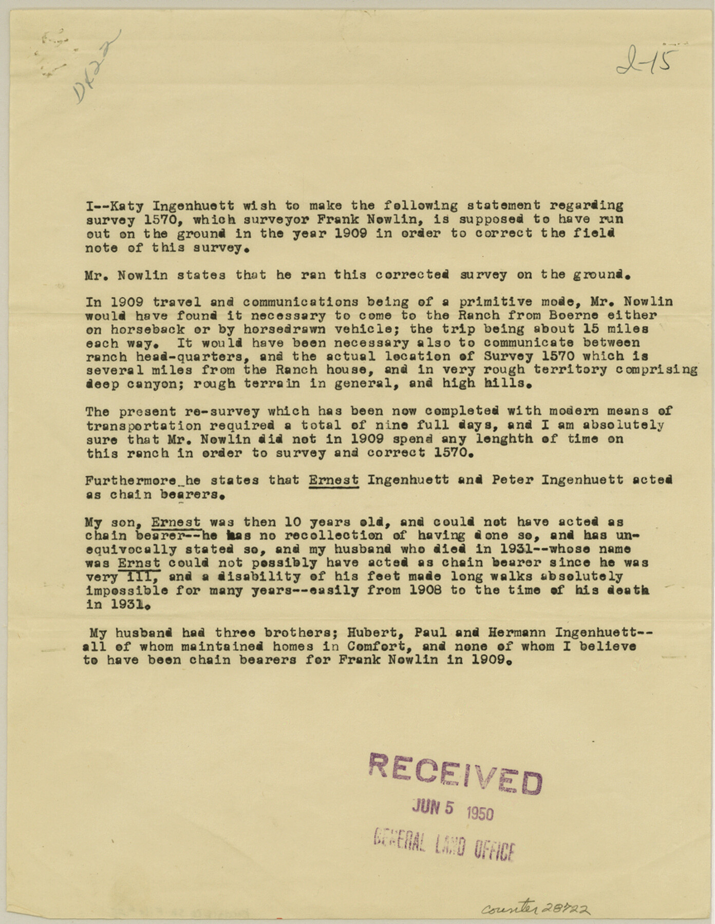
[Statement regarding survey 1570 by owner, Katy Ingenhuett]
-
Map/Doc
28722
-
Collection
General Map Collection
-
Object Dates
5/12/1950 (Creation Date)
6/19/1950 (File Date)
1909 (Survey Date)
-
People and Organizations
Frank Nowlin (Surveyor/Engineer)
-
Counties
Kendall
-
Subjects
Surveying Sketch File
-
Height x Width
11.2 x 8.6 inches
28.5 x 21.8 cm
-
Medium
paper, print
-
Features
Boerne
Part of: General Map Collection
Shelby County Sketch File 25

Print $6.00
- Digital $50.00
Shelby County Sketch File 25
Size 4.8 x 5.3 inches
Map/Doc 36657
Burnet County Boundary File 12

Print $14.00
- Digital $50.00
Burnet County Boundary File 12
Size 8.2 x 6.0 inches
Map/Doc 50949
Wichita County Working Sketch 8

Print $20.00
- Digital $50.00
Wichita County Working Sketch 8
1919
Size 18.3 x 37.7 inches
Map/Doc 72517
Zavala County Sketch File 12

Print $54.00
- Digital $50.00
Zavala County Sketch File 12
1886
Size 9.0 x 7.7 inches
Map/Doc 41279
Nolan County Working Sketch 5

Print $3.00
- Digital $50.00
Nolan County Working Sketch 5
1950
Size 9.7 x 13.9 inches
Map/Doc 71296
Flight Mission No. CRC-3R, Frame 8, Chambers County

Print $20.00
- Digital $50.00
Flight Mission No. CRC-3R, Frame 8, Chambers County
1956
Size 18.6 x 22.2 inches
Map/Doc 84782
Travis County Working Sketch 59

Print $20.00
- Digital $50.00
Travis County Working Sketch 59
1992
Size 33.1 x 29.0 inches
Map/Doc 69443
Newton County Working Sketch 18

Print $20.00
- Digital $50.00
Newton County Working Sketch 18
1950
Size 14.3 x 13.6 inches
Map/Doc 71264
Morris County Rolled Sketch 2A

Print $20.00
- Digital $50.00
Morris County Rolled Sketch 2A
Size 24.5 x 19.4 inches
Map/Doc 10248
Van Zandt County Sketch File 37

Print $4.00
- Digital $50.00
Van Zandt County Sketch File 37
1861
Size 12.2 x 7.8 inches
Map/Doc 39480
Presidio County Rolled Sketch 116

Print $20.00
- Digital $50.00
Presidio County Rolled Sketch 116
1981
Size 30.9 x 25.0 inches
Map/Doc 9795
Hamilton County Sketch File 5

Print $4.00
- Digital $50.00
Hamilton County Sketch File 5
Size 10.2 x 8.1 inches
Map/Doc 24908
You may also like
Parker County Rolled Sketch 1

Print $20.00
- Digital $50.00
Parker County Rolled Sketch 1
1878
Size 19.8 x 24.6 inches
Map/Doc 7202
Hays County Rolled Sketch 20

Print $20.00
- Digital $50.00
Hays County Rolled Sketch 20
Size 14.1 x 36.9 inches
Map/Doc 6176
Travis County Appraisal District Plat Map 2_1004

Print $20.00
- Digital $50.00
Travis County Appraisal District Plat Map 2_1004
Size 21.4 x 26.5 inches
Map/Doc 94238
Flight Mission No. BRA-8M, Frame 87, Jefferson County

Print $20.00
- Digital $50.00
Flight Mission No. BRA-8M, Frame 87, Jefferson County
1953
Size 18.6 x 22.3 inches
Map/Doc 85607
Sketch Showing Division Fence Shelton-Matador

Print $20.00
- Digital $50.00
Sketch Showing Division Fence Shelton-Matador
Size 21.3 x 24.1 inches
Map/Doc 91446
Bowie County Working Sketch 26

Print $20.00
- Digital $50.00
Bowie County Working Sketch 26
1980
Size 29.1 x 24.7 inches
Map/Doc 67430
Travis County Appraisal District Plat Map 1_1808

Print $20.00
- Digital $50.00
Travis County Appraisal District Plat Map 1_1808
Size 21.5 x 26.5 inches
Map/Doc 94214
[Gulf Colorado & Santa Fe from 2178+36.0 to 3901+06.2]
![64696, [Gulf Colorado & Santa Fe from 2178+36.0 to 3901+06.2], General Map Collection](https://historictexasmaps.com/wmedia_w700/maps/64696-1.tif.jpg)
Print $40.00
- Digital $50.00
[Gulf Colorado & Santa Fe from 2178+36.0 to 3901+06.2]
Size 32.0 x 120.5 inches
Map/Doc 64696

Cameron County Rolled Sketch 28A

Print $20.00
- Digital $50.00
Cameron County Rolled Sketch 28A
1986
Size 36.0 x 47.6 inches
Map/Doc 8576
Flight Mission No. DAG-23K, Frame 170, Matagorda County

Print $20.00
- Digital $50.00
Flight Mission No. DAG-23K, Frame 170, Matagorda County
1953
Size 18.6 x 22.4 inches
Map/Doc 86508
Bosque County Working Sketch 5

Print $20.00
- Digital $50.00
Bosque County Working Sketch 5
1935
Size 20.5 x 28.9 inches
Map/Doc 67438