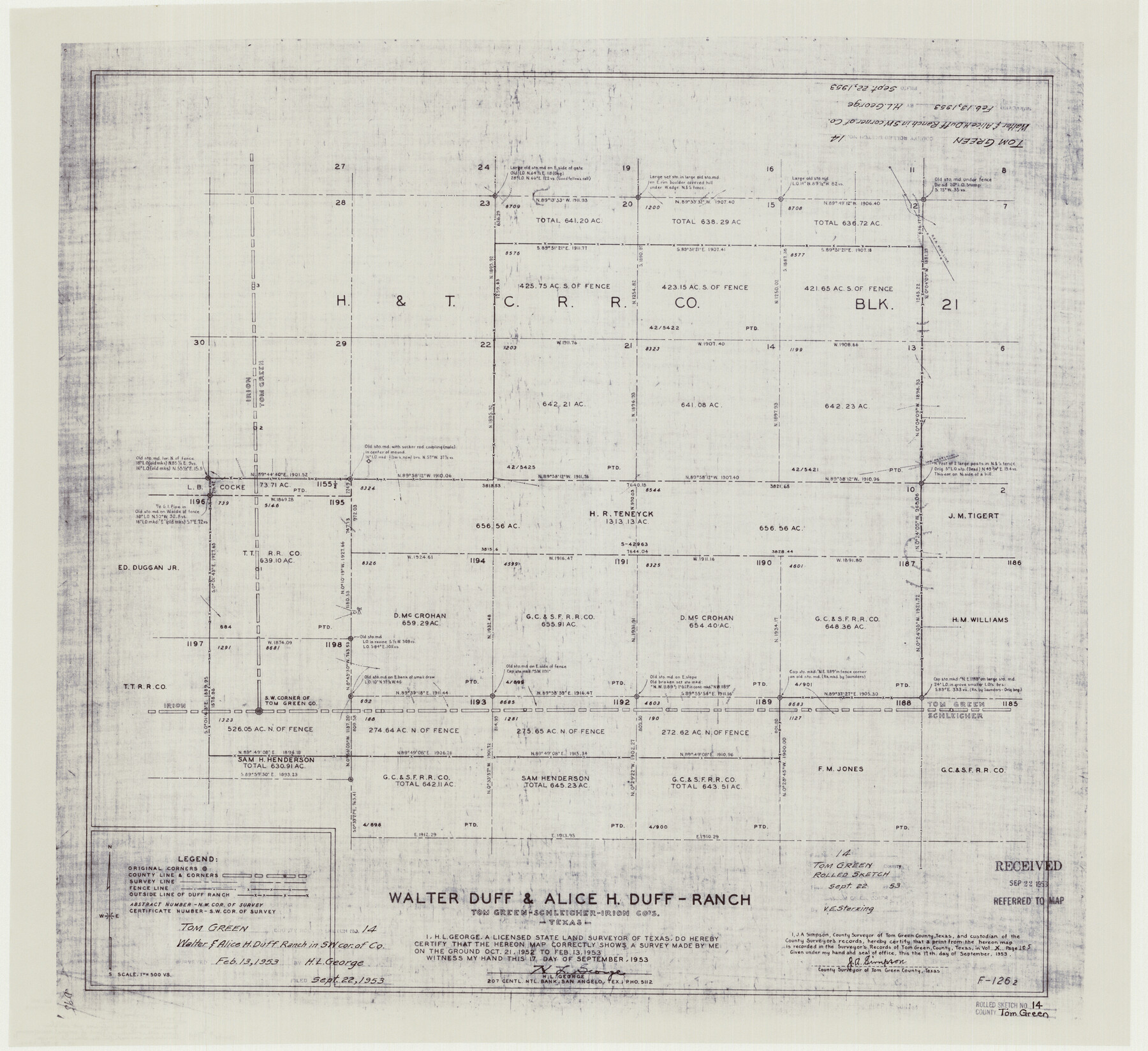
Tom Green County Rolled Sketch 14
Walter Duff & Alice H. Duff Ranch, Tom Green, Schleicher & Irion Cos., Texas
-
Map/Doc
7999
-
Collection
General Map Collection
-
Object Dates
9/17/1953 (Creation Date)
9/22/1953 (File Date)
2/13/1953 (Survey Date)
-
People and Organizations
H.L. George (Surveyor/Engineer)
-
Counties
Tom Green Schleicher Irion
-
Subjects
Surveying Rolled Sketch
-
Height x Width
28.3 x 30.9 inches
71.9 x 78.5 cm
-
Medium
blueprint/diazo
-
Scale
1" = 500 varas
Part of: General Map Collection
Brazoria County Rolled Sketch 25A

Print $259.00
- Digital $50.00
Brazoria County Rolled Sketch 25A
Size 10.1 x 17.0 inches
Map/Doc 42749
Flight Mission No. CUG-2P, Frame 59, Kleberg County

Print $20.00
- Digital $50.00
Flight Mission No. CUG-2P, Frame 59, Kleberg County
1956
Size 18.4 x 22.1 inches
Map/Doc 86196
Menard County Sketch File 13

Print $4.00
- Digital $50.00
Menard County Sketch File 13
1892
Size 12.8 x 8.2 inches
Map/Doc 31506
Orange County Rolled Sketch 12

Print $20.00
- Digital $50.00
Orange County Rolled Sketch 12
Size 23.6 x 19.2 inches
Map/Doc 7179
Jefferson County NRC Article 33.136 Sketch 4

Print $2.00
- Digital $50.00
Jefferson County NRC Article 33.136 Sketch 4
2004
Size 14.5 x 8.4 inches
Map/Doc 82993
La Salle County Working Sketch 5

Print $20.00
- Digital $50.00
La Salle County Working Sketch 5
1915
Size 17.2 x 13.4 inches
Map/Doc 70306
Dimmit County Working Sketch 17

Print $20.00
- Digital $50.00
Dimmit County Working Sketch 17
1943
Size 27.4 x 24.7 inches
Map/Doc 68678
Flight Mission No. CUG-3P, Frame 194, Kleberg County

Print $20.00
- Digital $50.00
Flight Mission No. CUG-3P, Frame 194, Kleberg County
1956
Size 18.4 x 22.2 inches
Map/Doc 86298
Real County Working Sketch 75

Print $20.00
- Digital $50.00
Real County Working Sketch 75
1979
Size 29.0 x 28.6 inches
Map/Doc 71967
Flight Mission No. DCL-7C, Frame 28, Kenedy County

Print $20.00
- Digital $50.00
Flight Mission No. DCL-7C, Frame 28, Kenedy County
1943
Size 15.4 x 15.4 inches
Map/Doc 86020
Roberts County Working Sketch 10

Print $20.00
- Digital $50.00
Roberts County Working Sketch 10
1965
Size 23.0 x 29.0 inches
Map/Doc 63536
Glasscock County Working Sketch 10

Print $40.00
- Digital $50.00
Glasscock County Working Sketch 10
1957
Size 77.9 x 37.2 inches
Map/Doc 63183
You may also like
Pecos County Working Sketch Graphic Index - northeast part - sheet B

Print $20.00
- Digital $50.00
Pecos County Working Sketch Graphic Index - northeast part - sheet B
1975
Size 36.0 x 42.2 inches
Map/Doc 76667
Padre Island National Seashore

Print $4.00
- Digital $50.00
Padre Island National Seashore
Size 16.0 x 22.1 inches
Map/Doc 60528
Archer County Working Sketch 5

Print $20.00
- Digital $50.00
Archer County Working Sketch 5
1919
Size 14.7 x 23.4 inches
Map/Doc 67145
W. L. Ellwood's O Ranch, Lubbock and Hockley Co.

Print $20.00
- Digital $50.00
W. L. Ellwood's O Ranch, Lubbock and Hockley Co.
Size 15.5 x 23.8 inches
Map/Doc 92762
Schleicher County Working Sketch 19

Print $20.00
- Digital $50.00
Schleicher County Working Sketch 19
1948
Size 43.5 x 38.9 inches
Map/Doc 63821
Roberts County Rolled Sketch 3

Print $40.00
- Digital $50.00
Roberts County Rolled Sketch 3
Size 38.0 x 49.7 inches
Map/Doc 8354
Fractional Township No. 9 South Range No. 1 East of the Indian Meridian, Indian Territory

Print $20.00
- Digital $50.00
Fractional Township No. 9 South Range No. 1 East of the Indian Meridian, Indian Territory
1898
Size 19.2 x 24.4 inches
Map/Doc 75201
Flight Mission No. DQO-3K, Frame 32, Galveston County

Print $20.00
- Digital $50.00
Flight Mission No. DQO-3K, Frame 32, Galveston County
1952
Size 18.7 x 22.5 inches
Map/Doc 85073
Chambers County Working Sketch 10

Print $20.00
- Digital $50.00
Chambers County Working Sketch 10
1950
Size 40.1 x 33.0 inches
Map/Doc 67993
Lubbock Cemetery

Print $40.00
- Digital $50.00
Lubbock Cemetery
Size 42.2 x 53.7 inches
Map/Doc 89912
Railroad Track Map, H&TCRRCo., Falls County, Texas

Print $4.00
- Digital $50.00
Railroad Track Map, H&TCRRCo., Falls County, Texas
1918
Size 11.7 x 18.4 inches
Map/Doc 62862
Flight Mission No. DQN-2K, Frame 33, Calhoun County

Print $20.00
- Digital $50.00
Flight Mission No. DQN-2K, Frame 33, Calhoun County
1953
Size 18.6 x 22.2 inches
Map/Doc 84240