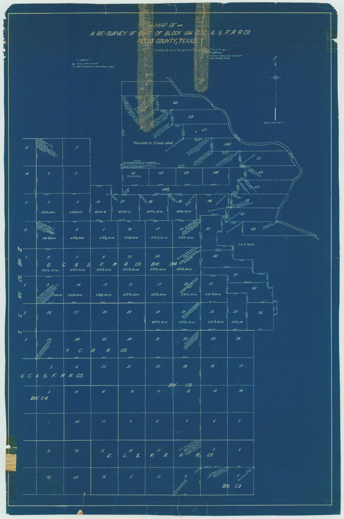
Pecos County Rolled Sketch 85
Map of a re-survey of part of Block 194, G. C. & S. F. R.R. Co., Pecos County, Texas
-
Map/Doc
7243
-
Collection
General Map Collection
-
Object Dates
1931/8/17 (Creation Date)
-
People and Organizations
J.A. Simpson (Surveyor/Engineer)
-
Counties
Pecos
-
Subjects
Surveying Rolled Sketch
-
Height x Width
36.7 x 24.4 inches
93.2 x 62.0 cm
-
Medium
blueprint/diazo
-
Scale
1" = 1000 varas
Part of: General Map Collection
Kimble County Sketch File 13

Print $24.00
- Digital $50.00
Kimble County Sketch File 13
1885
Size 14.1 x 8.6 inches
Map/Doc 28937
Potter County Boundary File 6a

Print $20.00
- Digital $50.00
Potter County Boundary File 6a
Size 43.8 x 15.6 inches
Map/Doc 58039
Crosby County Rolled Sketch 1A

Print $20.00
- Digital $50.00
Crosby County Rolled Sketch 1A
1950
Size 26.1 x 22.2 inches
Map/Doc 5641
Wilbarger Co.

Print $40.00
- Digital $50.00
Wilbarger Co.
1949
Size 48.2 x 39.2 inches
Map/Doc 63128
Flight Mission No. CLL-1N, Frame 190, Willacy County

Print $20.00
- Digital $50.00
Flight Mission No. CLL-1N, Frame 190, Willacy County
1954
Size 18.5 x 22.2 inches
Map/Doc 87060
Rusk County Working Sketch 33

Print $20.00
- Digital $50.00
Rusk County Working Sketch 33
1919
Size 20.1 x 16.6 inches
Map/Doc 63670
Chart of soundings through the different channels in Aransas and Matagorda Bays as taken in 1855 by Capt. R. B. Marey, U. S. A. [Inset: Harbour of Lamar and Live-Oak Pt.]
![72977, Chart of soundings through the different channels in Aransas and Matagorda Bays as taken in 1855 by Capt. R. B. Marey, U. S. A. [Inset: Harbour of Lamar and Live-Oak Pt.], General Map Collection](https://historictexasmaps.com/wmedia_w700/maps/72977.tif.jpg)
Print $20.00
- Digital $50.00
Chart of soundings through the different channels in Aransas and Matagorda Bays as taken in 1855 by Capt. R. B. Marey, U. S. A. [Inset: Harbour of Lamar and Live-Oak Pt.]
Size 28.1 x 18.2 inches
Map/Doc 72977
Glasscock County Rolled Sketch 15

Print $20.00
- Digital $50.00
Glasscock County Rolled Sketch 15
1964
Size 36.5 x 35.8 inches
Map/Doc 9059
Lubbock County

Print $20.00
- Digital $50.00
Lubbock County
1915
Size 46.1 x 40.0 inches
Map/Doc 66911
Coast Chart No. 210 Aransas Pass and Corpus Christi Bay with the coast to latitude 27° 12' Texas

Print $20.00
- Digital $50.00
Coast Chart No. 210 Aransas Pass and Corpus Christi Bay with the coast to latitude 27° 12' Texas
1887
Size 27.5 x 18.2 inches
Map/Doc 72802
Flight Mission No. BRA-3M, Frame 195, Jefferson County

Print $20.00
- Digital $50.00
Flight Mission No. BRA-3M, Frame 195, Jefferson County
1953
Size 18.6 x 22.3 inches
Map/Doc 85410
Leon County Rolled Sketch 5

Print $20.00
- Digital $50.00
Leon County Rolled Sketch 5
1947
Size 33.7 x 34.8 inches
Map/Doc 9427
You may also like
Tyler County Sketch File 17a

Print $4.00
- Digital $50.00
Tyler County Sketch File 17a
1853
Size 6.6 x 8.0 inches
Map/Doc 38664
Lubbock County Working Sketch 3

Print $20.00
- Digital $50.00
Lubbock County Working Sketch 3
1904
Size 13.9 x 20.5 inches
Map/Doc 70663
Maps of Gulf Intracoastal Waterway, Texas - Sabine River to the Rio Grande and connecting waterways including ship channels

Print $20.00
- Digital $50.00
Maps of Gulf Intracoastal Waterway, Texas - Sabine River to the Rio Grande and connecting waterways including ship channels
1966
Size 14.6 x 22.2 inches
Map/Doc 61945
Jim Hogg County Sketch File 5

Print $20.00
- Digital $50.00
Jim Hogg County Sketch File 5
1939
Size 24.8 x 19.9 inches
Map/Doc 11885
Burleson County Rolled Sketch 1

Print $631.00
- Digital $50.00
Burleson County Rolled Sketch 1
Size 10.2 x 16.5 inches
Map/Doc 43342
Freestone County Rolled Sketch 1

Print $20.00
- Digital $50.00
Freestone County Rolled Sketch 1
1947
Size 28.1 x 26.0 inches
Map/Doc 5909
Real County Working Sketch 25

Print $20.00
- Digital $50.00
Real County Working Sketch 25
1946
Size 26.5 x 24.7 inches
Map/Doc 71917
Sutton County Sketch File Ca

Print $6.00
- Digital $50.00
Sutton County Sketch File Ca
1901
Size 12.3 x 9.8 inches
Map/Doc 37382
Ellis Addition to the City of Lubbock, Being a Subdivision of a Part of the SW/4 of SW/4 Sec. 4, Blk. A

Print $3.00
- Digital $50.00
Ellis Addition to the City of Lubbock, Being a Subdivision of a Part of the SW/4 of SW/4 Sec. 4, Blk. A
1952
Size 9.4 x 11.9 inches
Map/Doc 92709
Flight Mission No. DCL-7C, Frame 69, Kenedy County

Print $20.00
- Digital $50.00
Flight Mission No. DCL-7C, Frame 69, Kenedy County
1943
Size 15.4 x 15.2 inches
Map/Doc 86055
Hutchinson County Working Sketch 35

Print $20.00
- Digital $50.00
Hutchinson County Working Sketch 35
1978
Size 27.0 x 22.3 inches
Map/Doc 66395
Map of east part of West Bay & SW part of Galveston Bay, Galveston County showing subdivision for mineral development

Print $40.00
- Digital $50.00
Map of east part of West Bay & SW part of Galveston Bay, Galveston County showing subdivision for mineral development
1963
Size 42.0 x 59.6 inches
Map/Doc 3069