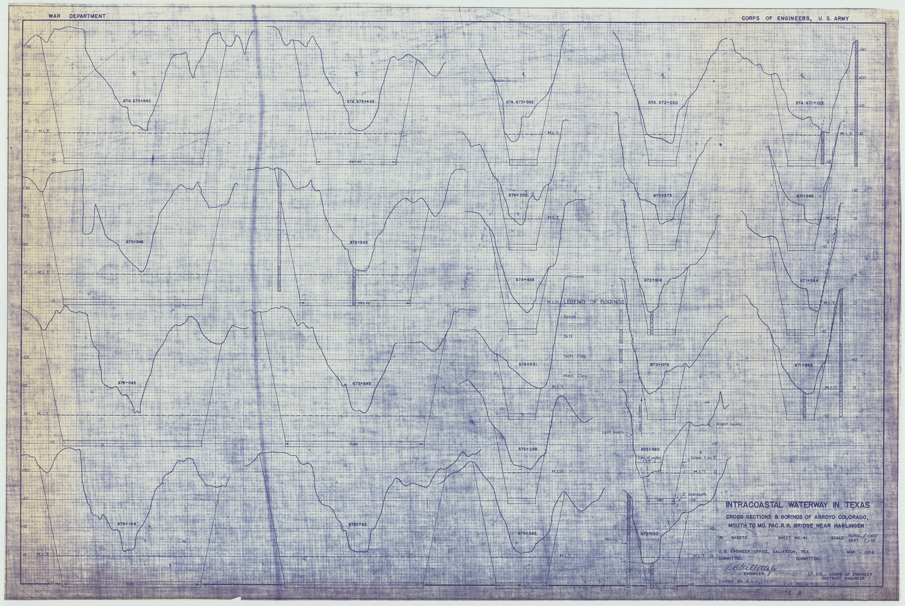
Intracoastal Waterway in Texas - Corpus Christi to Point Isabel including Arroyo Colorado to Mo. Pac. R.R. Bridge Near Harlingen
-
Map/Doc
61888
-
Collection
General Map Collection
-
Object Dates
1934 (Creation Date)
-
Subjects
Intracoastal Waterways
-
Height x Width
21.8 x 32.6 inches
55.4 x 82.8 cm
Part of: General Map Collection
Gray County Working Sketch 2

Print $20.00
- Digital $50.00
Gray County Working Sketch 2
1957
Size 26.7 x 27.8 inches
Map/Doc 63233
Zavala County Working Sketch 16

Print $20.00
- Digital $50.00
Zavala County Working Sketch 16
1977
Size 41.3 x 43.1 inches
Map/Doc 62091
Pecos County Sketch File 67

Print $76.00
- Digital $50.00
Pecos County Sketch File 67
1919
Size 14.1 x 8.8 inches
Map/Doc 33828
Flight Mission No. BRA-16M, Frame 127, Jefferson County

Print $20.00
- Digital $50.00
Flight Mission No. BRA-16M, Frame 127, Jefferson County
1953
Size 18.6 x 22.6 inches
Map/Doc 85737
Brewster County Sketch File N-13

Print $8.00
- Digital $50.00
Brewster County Sketch File N-13
1935
Size 14.3 x 8.7 inches
Map/Doc 15625
Tarrant County Working Sketch 11

Print $20.00
- Digital $50.00
Tarrant County Working Sketch 11
1986
Size 42.5 x 32.6 inches
Map/Doc 62428

Brewster County Rolled Sketch 81

Print $20.00
- Digital $50.00
Brewster County Rolled Sketch 81
Size 38.9 x 32.6 inches
Map/Doc 41812
Kinney County Sketch File B

Print $8.00
- Digital $50.00
Kinney County Sketch File B
1873
Size 11.9 x 8.1 inches
Map/Doc 29119
Harris County Rolled Sketch P57

Print $20.00
- Digital $50.00
Harris County Rolled Sketch P57
1929
Size 29.6 x 37.5 inches
Map/Doc 9118
Refugio County NRC Article 33.136 Sketch 3

Print $3.00
- Digital $50.00
Refugio County NRC Article 33.136 Sketch 3
2005
Size 11.2 x 17.3 inches
Map/Doc 83013
Cass County Working Sketch 16

Print $20.00
- Digital $50.00
Cass County Working Sketch 16
1957
Size 43.1 x 34.8 inches
Map/Doc 67919
You may also like
Gillespie County Sketch File 4a

Print $40.00
- Digital $50.00
Gillespie County Sketch File 4a
Size 15.8 x 12.8 inches
Map/Doc 24137
Colorado County Sketch File 3b

Print $4.00
- Digital $50.00
Colorado County Sketch File 3b
Size 7.0 x 8.2 inches
Map/Doc 18913
Working Sketch of Moore County

Print $20.00
- Digital $50.00
Working Sketch of Moore County
Size 27.7 x 15.6 inches
Map/Doc 93002

Val Verde County Sketch File A1 1/2

Print $20.00
- Digital $50.00
Val Verde County Sketch File A1 1/2
Size 24.8 x 17.3 inches
Map/Doc 12539

Aransas County

Print $20.00
- Digital $50.00
Aransas County
1883
Size 19.9 x 17.1 inches
Map/Doc 3236

Galveston County Boundary File 32a

Print $10.00
- Digital $50.00
Galveston County Boundary File 32a
Size 11.4 x 8.9 inches
Map/Doc 53666
Hardin County Working Sketch 43

Print $20.00
- Digital $50.00
Hardin County Working Sketch 43
2001
Size 45.4 x 37.4 inches
Map/Doc 83572
Map of Partition Subdivision of A.B. Robertson's Ranch in Crosby and Garza Counties, Texas 1926

Print $20.00
- Digital $50.00
Map of Partition Subdivision of A.B. Robertson's Ranch in Crosby and Garza Counties, Texas 1926
1926
Size 39.1 x 42.7 inches
Map/Doc 89755
Flight Mission No. DIX-8P, Frame 90, Aransas County

Print $20.00
- Digital $50.00
Flight Mission No. DIX-8P, Frame 90, Aransas County
1956
Size 18.6 x 22.4 inches
Map/Doc 83915