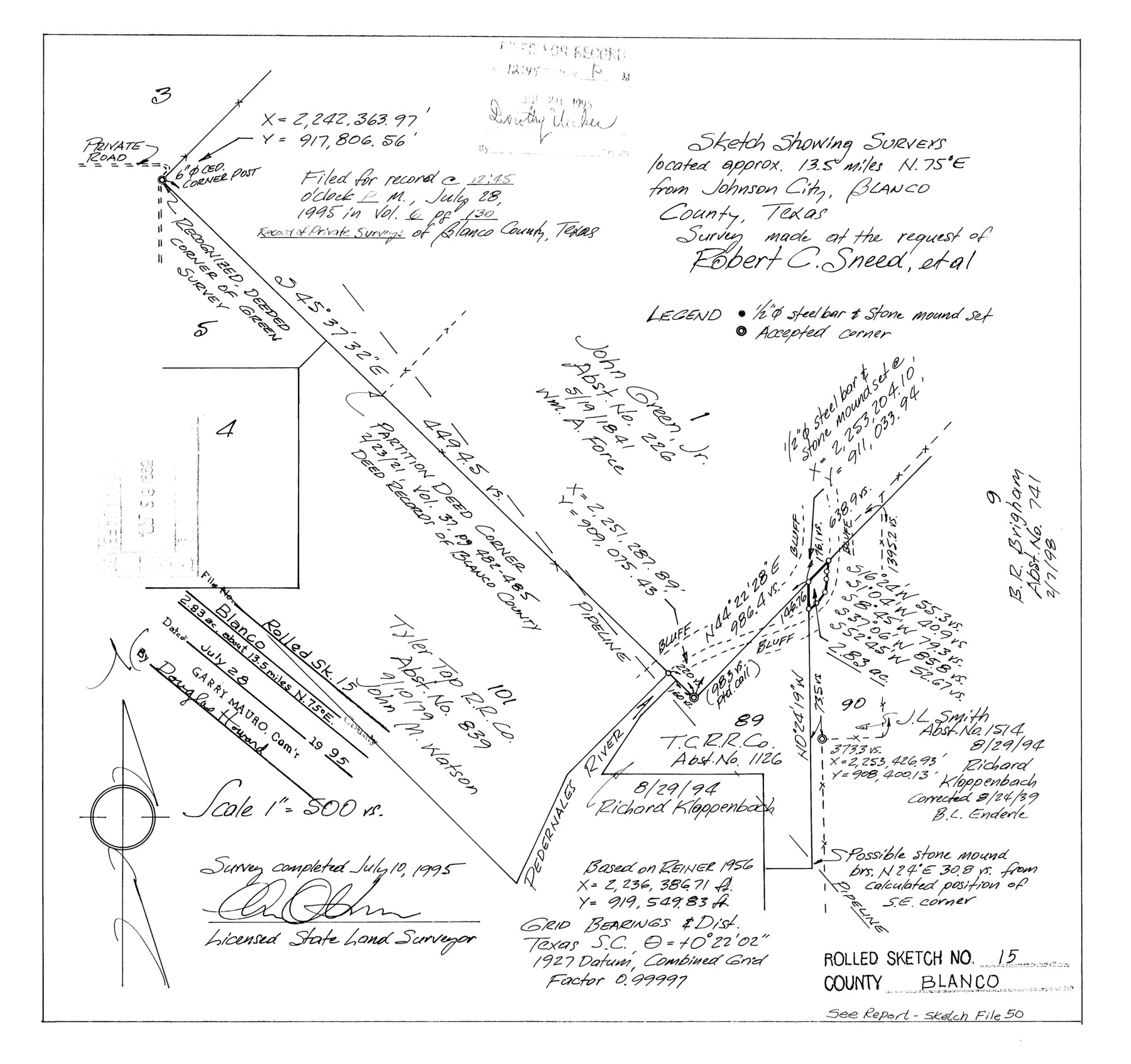
Blanco County Rolled Sketch 15
Sketch showing surveys located approx. 13.5 miles N 75° E from Johnson City, Blanco County, Texas - survey made at the request of Robert C. Sneed, et al
-
Map/Doc
5151
-
Collection
General Map Collection
-
Object Dates
1995/7/10 (Survey Date)
1995/7/28 (File Date)
-
People and Organizations
Charles Ottmers (Surveyor/Engineer)
-
Counties
Blanco
-
Subjects
Surveying Rolled Sketch
-
Height x Width
12.9 x 13.7 inches
32.8 x 34.8 cm
-
Medium
mylar, print
-
Scale
1" = 500 varas
-
Comments
See Blanco County Sketch File 50 (14695) for surveyor’s report.
Related maps
Blanco County Sketch File 50

Print $6.00
- Digital $50.00
Blanco County Sketch File 50
1995
Size 11.5 x 8.8 inches
Map/Doc 14695
Part of: General Map Collection
Controlled Mosaic by Jack Amman Photogrammetric Engineers, Inc - Sheet 25

Print $20.00
- Digital $50.00
Controlled Mosaic by Jack Amman Photogrammetric Engineers, Inc - Sheet 25
1954
Size 20.0 x 24.0 inches
Map/Doc 83476
Parker County Sketch File 6

Print $6.00
- Digital $50.00
Parker County Sketch File 6
1858
Size 6.9 x 6.0 inches
Map/Doc 33530
Presidio County Working Sketch 55

Print $20.00
- Digital $50.00
Presidio County Working Sketch 55
1955
Size 22.0 x 16.9 inches
Map/Doc 71732
[Map of] North America
![88884, [Map of] North America, General Map Collection](https://historictexasmaps.com/wmedia_w700/maps/88884.tif.jpg)
Print $3.00
- Digital $50.00
[Map of] North America
1834
Size 11.0 x 8.5 inches
Map/Doc 88884
Kimble County Rolled Sketch 41

Print $40.00
- Digital $50.00
Kimble County Rolled Sketch 41
1994
Size 38.0 x 48.9 inches
Map/Doc 9340
Index sheet to accompany map of survey for connecting the inland waters along margin of the Gulf of Mexico from Donaldsonville in Louisiana to the Rio Grande River in Texas

Print $20.00
- Digital $50.00
Index sheet to accompany map of survey for connecting the inland waters along margin of the Gulf of Mexico from Donaldsonville in Louisiana to the Rio Grande River in Texas
1874
Size 18.2 x 27.1 inches
Map/Doc 72695
Austin County Rolled Sketch 6

Print $20.00
- Digital $50.00
Austin County Rolled Sketch 6
1951
Size 25.5 x 34.0 inches
Map/Doc 5108
Map of the Surveyed Part of Young District

Print $40.00
- Digital $50.00
Map of the Surveyed Part of Young District
1860
Size 56.2 x 54.7 inches
Map/Doc 1986
Henderson County Working Sketch 4

Print $20.00
- Digital $50.00
Henderson County Working Sketch 4
1918
Size 21.2 x 16.0 inches
Map/Doc 66137
Sterling County Rolled Sketch 37

Print $20.00
- Digital $50.00
Sterling County Rolled Sketch 37
Size 13.7 x 16.6 inches
Map/Doc 7862
Galveston County Sketch File 73

Print $78.00
- Digital $50.00
Galveston County Sketch File 73
1998
Size 11.3 x 8.8 inches
Map/Doc 23980
Randall County Boundary File 2

Print $14.00
- Digital $50.00
Randall County Boundary File 2
Size 8.9 x 7.9 inches
Map/Doc 58111
You may also like
Cochran County Rolled Sketch 1

Print $40.00
- Digital $50.00
Cochran County Rolled Sketch 1
1938
Size 61.8 x 18.0 inches
Map/Doc 8606
El Paso County Working Sketch 44

Print $20.00
- Digital $50.00
El Paso County Working Sketch 44
1992
Size 25.6 x 25.4 inches
Map/Doc 69066
Map of Harris County

Print $20.00
- Digital $50.00
Map of Harris County
1893
Size 29.7 x 33.8 inches
Map/Doc 3632
Pressler's Map of the State of Texas

Print $40.00
Pressler's Map of the State of Texas
1858
Size 48.0 x 52.5 inches
Map/Doc 76232
[Sketch of Surveys in Brooks County, Texas]
![10775, [Sketch of Surveys in Brooks County, Texas], Maddox Collection](https://historictexasmaps.com/wmedia_w700/maps/10775.tif.jpg)
Print $20.00
- Digital $50.00
[Sketch of Surveys in Brooks County, Texas]
Size 12.1 x 12.4 inches
Map/Doc 10775
Railroad Track Map, H&TCRRCo., Falls County, Texas

Print $4.00
- Digital $50.00
Railroad Track Map, H&TCRRCo., Falls County, Texas
1918
Size 11.4 x 18.7 inches
Map/Doc 62857
Chambers County Sketch File 50

Print $49.00
- Digital $50.00
Chambers County Sketch File 50
1917
Size 14.4 x 8.8 inches
Map/Doc 18048
Flight Mission No. CZW-2R, Frame 25, Hardeman County

Print $20.00
- Digital $50.00
Flight Mission No. CZW-2R, Frame 25, Hardeman County
1956
Size 18.7 x 22.4 inches
Map/Doc 85237
Orange County Sketch File B1

Print $22.00
- Digital $50.00
Orange County Sketch File B1
Size 14.3 x 8.9 inches
Map/Doc 33288
Preliminary Sketch of Galveston Bay, Texas

Print $20.00
Preliminary Sketch of Galveston Bay, Texas
1852
Size 22.6 x 18.3 inches
Map/Doc 79317
Live Oak County Rolled Sketch 3

Print $20.00
- Digital $50.00
Live Oak County Rolled Sketch 3
1944
Size 31.2 x 47.2 inches
Map/Doc 10630
Map of a Part of Robertson Colony

Print $20.00
- Digital $50.00
Map of a Part of Robertson Colony
1843
Size 32.2 x 22.6 inches
Map/Doc 168