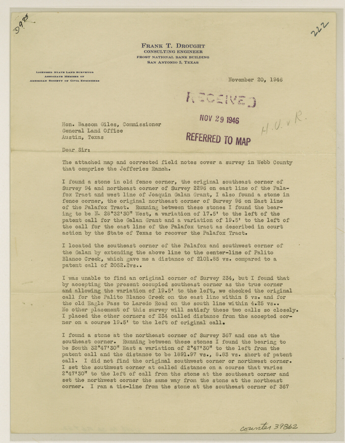
Webb County Sketch File 62
[Report of survey of Jefferies Ranch in the vicinity of the Galan grant northwest from Laredo]
-
Map/Doc
39862
-
Collection
General Map Collection
-
Object Dates
11/20/1946 (Creation Date)
2/11/1947 (File Date)
-
People and Organizations
Frank T. Drought (Surveyor/Engineer)
-
Counties
Webb
-
Subjects
Surveying Sketch File
-
Height x Width
11.5 x 9.0 inches
29.2 x 22.9 cm
-
Medium
paper, print
-
Comments
See Webb County Rolled Sketch 58 (10127) for sketch.
-
Features
Palito Blanco Creek
Jefferies Ranch
Related maps
Webb County Rolled Sketch 58

Print $40.00
- Digital $50.00
Webb County Rolled Sketch 58
1946
Size 36.7 x 53.4 inches
Map/Doc 10127
Part of: General Map Collection
McLennan County Sketch File 1a

Print $4.00
- Digital $50.00
McLennan County Sketch File 1a
1872
Size 8.0 x 12.2 inches
Map/Doc 31226
Tyler County Sketch File 6-1

Print $6.00
- Digital $50.00
Tyler County Sketch File 6-1
1861
Size 13.3 x 9.3 inches
Map/Doc 38633
Harris County State Real Property Sketch 5

Print $20.00
- Digital $50.00
Harris County State Real Property Sketch 5
2003
Size 24.5 x 36.0 inches
Map/Doc 82007
Concho County Working Sketch 13

Print $20.00
- Digital $50.00
Concho County Working Sketch 13
1954
Size 26.3 x 14.1 inches
Map/Doc 68195
Culberson County Working Sketch Graphic Index, Sheet B (Sketches 41 to Most Recent)

Print $40.00
- Digital $50.00
Culberson County Working Sketch Graphic Index, Sheet B (Sketches 41 to Most Recent)
1943
Size 52.5 x 32.5 inches
Map/Doc 76515
Henderson County

Print $20.00
- Digital $50.00
Henderson County
1856
Size 17.9 x 29.2 inches
Map/Doc 3664
Presidio County Rolled Sketch 68

Print $20.00
- Digital $50.00
Presidio County Rolled Sketch 68
1927
Size 11.8 x 24.4 inches
Map/Doc 7358
Sabine County Rolled Sketch 2

Print $20.00
- Digital $50.00
Sabine County Rolled Sketch 2
1949
Size 33.3 x 20.8 inches
Map/Doc 7551
El Paso County Rolled Sketch 54

Print $20.00
- Digital $50.00
El Paso County Rolled Sketch 54
1980
Size 30.4 x 42.8 inches
Map/Doc 44539
McLennan County Sketch File 23

Print $4.00
- Digital $50.00
McLennan County Sketch File 23
Size 5.6 x 3.2 inches
Map/Doc 31297
Runnels County Sketch File 18

Print $10.00
Runnels County Sketch File 18
1892
Size 14.0 x 8.4 inches
Map/Doc 35476
Presidio County Working Sketch 94

Print $20.00
- Digital $50.00
Presidio County Working Sketch 94
1976
Size 40.6 x 32.1 inches
Map/Doc 71771
You may also like
[Railroad Map of Falfurias to Hidalgo, Hidalgo County]
![89422, [Railroad Map of Falfurias to Hidalgo, Hidalgo County], Barnes Railroad Collection](https://historictexasmaps.com/wmedia_w700/maps/89422-1.tif.jpg)
Print $40.00
- Digital $50.00
[Railroad Map of Falfurias to Hidalgo, Hidalgo County]
Size 25.0 x 146.5 inches
Map/Doc 89422
Reagan County Sketch File 2B

Print $20.00
- Digital $50.00
Reagan County Sketch File 2B
Size 20.4 x 22.2 inches
Map/Doc 12212
Denton County

Print $20.00
- Digital $50.00
Denton County
1947
Size 43.4 x 39.9 inches
Map/Doc 95480
Navarro County, 1888

Print $20.00
- Digital $50.00
Navarro County, 1888
1888
Size 43.8 x 32.2 inches
Map/Doc 89651
Oldham County Rolled Sketch 12

Print $20.00
- Digital $50.00
Oldham County Rolled Sketch 12
1981
Size 25.2 x 38.0 inches
Map/Doc 7177
Sketch in Crockett County, Texas

Print $20.00
- Digital $50.00
Sketch in Crockett County, Texas
Size 27.8 x 23.4 inches
Map/Doc 90474
[Right of Way & Track Map, The Texas & Pacific Ry. Co. Main Line]
![64666, [Right of Way & Track Map, The Texas & Pacific Ry. Co. Main Line], General Map Collection](https://historictexasmaps.com/wmedia_w700/maps/64666.tif.jpg)
Print $20.00
- Digital $50.00
[Right of Way & Track Map, The Texas & Pacific Ry. Co. Main Line]
Size 11.0 x 18.5 inches
Map/Doc 64666
Flight Mission No. DQO-1K, Frame 152, Galveston County

Print $20.00
- Digital $50.00
Flight Mission No. DQO-1K, Frame 152, Galveston County
1952
Size 18.9 x 22.5 inches
Map/Doc 85005
General Highway Map, Howard County, Texas

Print $20.00
General Highway Map, Howard County, Texas
1940
Size 18.5 x 24.7 inches
Map/Doc 79134
Garza County Sketch File C

Print $22.00
- Digital $50.00
Garza County Sketch File C
1900
Size 18.0 x 10.8 inches
Map/Doc 24013
Flight Mission No. BRA-3M, Frame 118, Jefferson County

Print $20.00
- Digital $50.00
Flight Mission No. BRA-3M, Frame 118, Jefferson County
1953
Size 18.6 x 22.3 inches
Map/Doc 85392
Lynn County Rolled Sketch 5

Print $20.00
- Digital $50.00
Lynn County Rolled Sketch 5
1912
Size 17.1 x 26.4 inches
Map/Doc 6645