Navarro County Sketch File 19
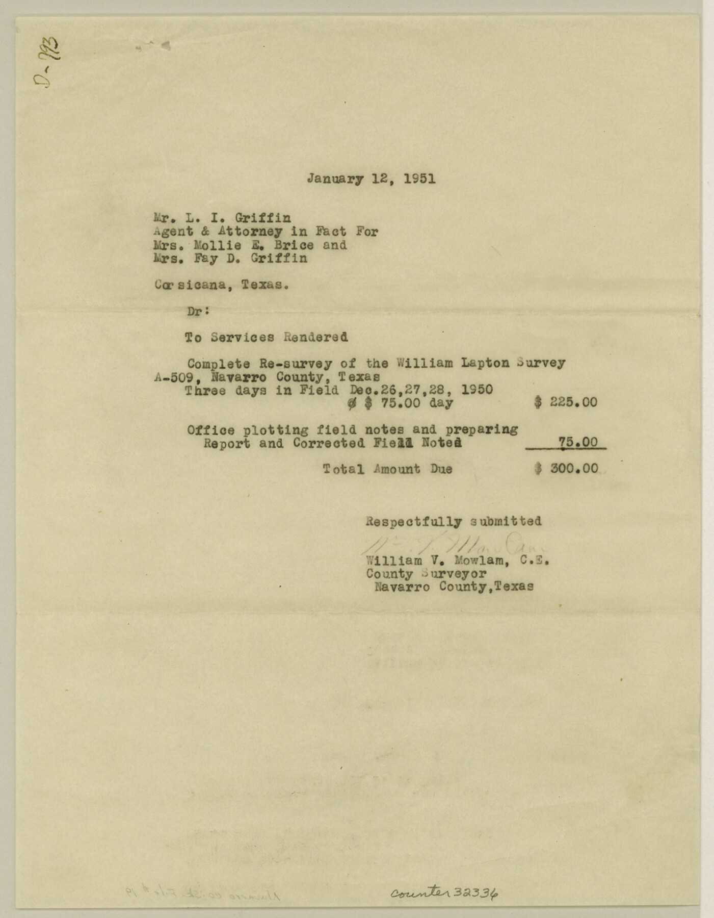
[Report of the resurvey of the William Lapton survey A-509]
-
Map/Doc
32336
-
Collection
General Map Collection
-
Object Dates
1/4/1951 (Creation Date)
1/18/1951 (File Date)
1/12/1951 (Correspondence Date)
-
People and Organizations
William V. Mowlam (Surveyor/Engineer)
-
Counties
Navarro Ellis
-
Subjects
Surveying Sketch File
-
Height x Width
11.4 x 8.8 inches
29.0 x 22.4 cm
-
Medium
paper, print
-
Features
Chambers Creek
T&BV
Part of: General Map Collection
Aransas County Rolled Sketch 24A

Print $20.00
- Digital $50.00
Aransas County Rolled Sketch 24A
Size 15.8 x 24.1 inches
Map/Doc 5062
Walker County Working Sketch 2

Print $20.00
- Digital $50.00
Walker County Working Sketch 2
1918
Size 16.7 x 14.5 inches
Map/Doc 72282
Coke County Rolled Sketch 14B

Print $20.00
- Digital $50.00
Coke County Rolled Sketch 14B
Size 16.3 x 19.3 inches
Map/Doc 5516
Hartley County Sketch File 2

Print $22.00
- Digital $50.00
Hartley County Sketch File 2
Size 8.9 x 13.6 inches
Map/Doc 26085
Travis County

Print $40.00
- Digital $50.00
Travis County
1936
Size 46.9 x 54.1 inches
Map/Doc 95479
Map of Ellis County

Print $20.00
- Digital $50.00
Map of Ellis County
1857
Size 20.2 x 28.1 inches
Map/Doc 3510
Hartley County

Print $20.00
- Digital $50.00
Hartley County
1925
Size 34.2 x 41.5 inches
Map/Doc 77306
Harris County NRC Article 33.136 Sketch 7

Print $20.00
- Digital $50.00
Harris County NRC Article 33.136 Sketch 7
2004
Size 24.3 x 18.5 inches
Map/Doc 82991
Intracoastal Waterway in Texas - Corpus Christi to Point Isabel including Arroyo Colorado to Mo. Pac. R.R. Bridge Near Harlingen

Print $20.00
- Digital $50.00
Intracoastal Waterway in Texas - Corpus Christi to Point Isabel including Arroyo Colorado to Mo. Pac. R.R. Bridge Near Harlingen
1933
Size 27.9 x 40.9 inches
Map/Doc 61865
Maps of Gulf Intracoastal Waterway, Texas - Sabine River to the Rio Grande and connecting waterways including ship channels

Print $20.00
- Digital $50.00
Maps of Gulf Intracoastal Waterway, Texas - Sabine River to the Rio Grande and connecting waterways including ship channels
1966
Size 14.5 x 22.2 inches
Map/Doc 61919
Comanche County Working Sketch 6

Print $20.00
- Digital $50.00
Comanche County Working Sketch 6
1935
Size 26.4 x 17.8 inches
Map/Doc 68140
Red River County Working Sketch 74

Print $20.00
- Digital $50.00
Red River County Working Sketch 74
1980
Size 24.2 x 22.8 inches
Map/Doc 72057
You may also like
Loving County State of Texas

Print $20.00
- Digital $50.00
Loving County State of Texas
1889
Size 20.5 x 24.5 inches
Map/Doc 4581
Harris County Working Sketch 122

Print $20.00
- Digital $50.00
Harris County Working Sketch 122
1986
Size 30.0 x 40.1 inches
Map/Doc 66014
Chambers County Sketch File 58

Print $2.00
- Digital $50.00
Chambers County Sketch File 58
1995
Size 9.1 x 14.7 inches
Map/Doc 18108
General Highway Map Bailey County, Texas

Print $20.00
- Digital $50.00
General Highway Map Bailey County, Texas
1948
Size 18.7 x 25.8 inches
Map/Doc 92533
Harris County Working Sketch 81

Print $20.00
- Digital $50.00
Harris County Working Sketch 81
1969
Size 23.6 x 30.0 inches
Map/Doc 65973
Gregg County Working Sketch 11b

Print $20.00
- Digital $50.00
Gregg County Working Sketch 11b
1940
Size 11.9 x 15.3 inches
Map/Doc 63278
Palo Pinto County Working Sketch 23

Print $40.00
- Digital $50.00
Palo Pinto County Working Sketch 23
1985
Map/Doc 71406
Map of Eastham State Farm, Houston County, Texas

Print $20.00
- Digital $50.00
Map of Eastham State Farm, Houston County, Texas
Size 35.7 x 32.5 inches
Map/Doc 62987
Terrell County Working Sketch 64

Print $20.00
- Digital $50.00
Terrell County Working Sketch 64
1971
Size 29.3 x 27.7 inches
Map/Doc 69585
Red River County Working Sketch 74
Print $20.00
- Digital $50.00
Red River County Working Sketch 74
1980
Size 24.2 x 22.8 inches
Map/Doc 72057
[Sketch for Mineral Application 19560 - 19588 - San Bernard River]
![65662, [Sketch for Mineral Application 19560 - 19588 - San Bernard River], General Map Collection](https://historictexasmaps.com/wmedia_w700/maps/65662.tif.jpg)
Print $40.00
- Digital $50.00
[Sketch for Mineral Application 19560 - 19588 - San Bernard River]
Size 31.6 x 73.6 inches
Map/Doc 65662
La Salle County Sketch File 40

Print $6.00
- Digital $50.00
La Salle County Sketch File 40
1918
Size 11.2 x 8.7 inches
Map/Doc 29594