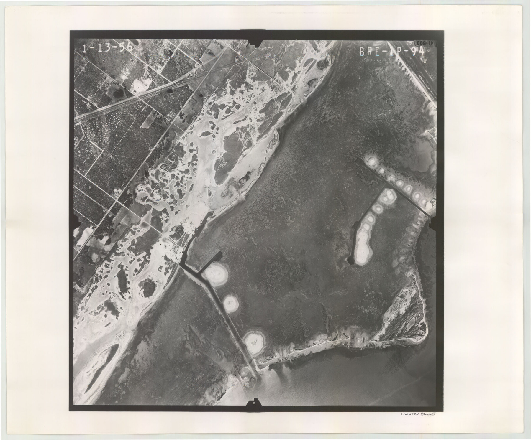
Flight Mission No. BRE-1P, Frame 94, Nueces County
BRE-1P-94
-
Map/Doc
86665
-
Collection
General Map Collection
-
Object Dates
1956/1/13 (Creation Date)
-
People and Organizations
U. S. Department of Agriculture (Publisher)
-
Counties
Nueces
-
Subjects
Aerial Photograph
-
Height x Width
18.6 x 22.4 inches
47.2 x 56.9 cm
-
Comments
Flown by V. L. Beavers and Associates of San Antonio, Texas.
Part of: General Map Collection
Wise County Sketch File 11

Print $4.00
- Digital $50.00
Wise County Sketch File 11
1860
Size 12.8 x 8.0 inches
Map/Doc 40544
Sterling County Rolled Sketch 11

Print $20.00
- Digital $50.00
Sterling County Rolled Sketch 11
1884
Size 22.5 x 46.6 inches
Map/Doc 9945
El Paso County Boundary File 19

Print $9.00
- Digital $50.00
El Paso County Boundary File 19
Size 13.6 x 8.7 inches
Map/Doc 53206
Wise County Sketch File 24

Print $4.00
- Digital $50.00
Wise County Sketch File 24
1860
Size 12.3 x 7.8 inches
Map/Doc 40570
Controlled Mosaic by Jack Amman Photogrammetric Engineers, Inc - Sheet 35

Print $20.00
- Digital $50.00
Controlled Mosaic by Jack Amman Photogrammetric Engineers, Inc - Sheet 35
1954
Size 20.0 x 24.0 inches
Map/Doc 83488
Aransas County Sketch File 18

Print $8.00
- Digital $50.00
Aransas County Sketch File 18
1888
Size 12.7 x 8.2 inches
Map/Doc 13149
Llano County Working Sketch 13

Print $20.00
- Digital $50.00
Llano County Working Sketch 13
1987
Size 23.0 x 22.3 inches
Map/Doc 70631
Spanish Province of Texas compiled from map on file among archives at Saltillo

Print $20.00
- Digital $50.00
Spanish Province of Texas compiled from map on file among archives at Saltillo
1897
Size 13.6 x 16.0 inches
Map/Doc 93412
Gonzales County Sketch File 1

Print $4.00
- Digital $50.00
Gonzales County Sketch File 1
1858
Size 8.1 x 10.2 inches
Map/Doc 24355
Brazoria County Working Sketch 35

Print $40.00
- Digital $50.00
Brazoria County Working Sketch 35
1981
Size 43.5 x 66.2 inches
Map/Doc 67520
Trinity County Sketch File 34A

Print $6.00
- Digital $50.00
Trinity County Sketch File 34A
1921
Size 16.6 x 10.8 inches
Map/Doc 38578

You may also like
Engineer's Office, Department of the Gulf Map No. 59, Texas prepared by order of Maj. Gen. N. P. Banks under direction of Capt. P. C. Hains, U. S. Engr. & Chief Engr., Dept. of the Gulf

Print $20.00
- Digital $50.00
Engineer's Office, Department of the Gulf Map No. 59, Texas prepared by order of Maj. Gen. N. P. Banks under direction of Capt. P. C. Hains, U. S. Engr. & Chief Engr., Dept. of the Gulf
1865
Size 18.2 x 27.5 inches
Map/Doc 72716
Presidio County

Print $40.00
- Digital $50.00
Presidio County
1875
Size 98.1 x 58.7 inches
Map/Doc 16792
Kinney County Working Sketch 31

Print $20.00
- Digital $50.00
Kinney County Working Sketch 31
1961
Size 30.9 x 47.3 inches
Map/Doc 70213
Montgomery County Working Sketch 1

Print $20.00
- Digital $50.00
Montgomery County Working Sketch 1
1912
Size 20.8 x 17.1 inches
Map/Doc 71107
Tom Green County Working Sketch 13

Print $20.00
- Digital $50.00
Tom Green County Working Sketch 13
1981
Size 34.3 x 26.4 inches
Map/Doc 69382
Northern Part of Laguna Madre
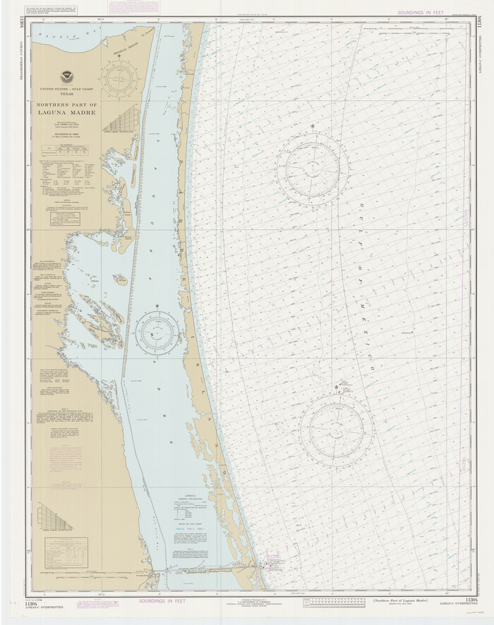
Print $20.00
- Digital $50.00
Northern Part of Laguna Madre
1982
Size 44.2 x 35.0 inches
Map/Doc 73530
Sectional Map No. 2 of the lands and the line of the Texas & Pacific Ry. Co. in Howard, Martin, Andrews, Midland and Tom Green Counties

Print $20.00
- Digital $50.00
Sectional Map No. 2 of the lands and the line of the Texas & Pacific Ry. Co. in Howard, Martin, Andrews, Midland and Tom Green Counties
1885
Size 18.9 x 23.4 inches
Map/Doc 4859

DeWitt County

Print $40.00
- Digital $50.00
DeWitt County
1987
Size 42.6 x 53.2 inches
Map/Doc 73131
Township No. 7 South Range No. 4 West of the Indian Meridian, Chickasaw Lands

Print $4.00
- Digital $50.00
Township No. 7 South Range No. 4 West of the Indian Meridian, Chickasaw Lands
1871
Size 18.2 x 22.4 inches
Map/Doc 75146
Rusk County Working Sketch 19

Print $20.00
- Digital $50.00
Rusk County Working Sketch 19
1955
Size 19.0 x 18.2 inches
Map/Doc 63654
Aransas County Working Sketch 20

Print $20.00
- Digital $50.00
Aransas County Working Sketch 20
1980
Size 11.9 x 24.4 inches
Map/Doc 67187