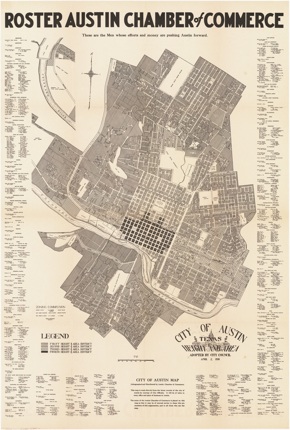
City of Austin, Texas - Height and Area adopted by City Council
-
Map/Doc
95712
-
Collection
General Map Collection
-
Object Dates
1931/4/2 (Publication Date)
-
People and Organizations
Austin Chamber of Commerce (Publisher)
Austin Chamber of Commerce (Printer)
-
Counties
Travis
-
Subjects
City
-
Height x Width
42.5 x 28.6 inches
108.0 x 72.6 cm
-
Medium
paper, etching/engraving/lithograph
-
Comments
Includes the roster of businesses in the Austin Chamber of Commerce around the margins of the map.
Part of: General Map Collection
Tom Green County Sketch File 66

Print $22.00
- Digital $50.00
Tom Green County Sketch File 66
1929
Size 16.8 x 14.6 inches
Map/Doc 38236
Johnson County Working Sketch 22

Print $20.00
- Digital $50.00
Johnson County Working Sketch 22
1992
Size 14.6 x 18.1 inches
Map/Doc 66635
Jim Hogg County Rolled Sketch 6

Print $40.00
- Digital $50.00
Jim Hogg County Rolled Sketch 6
1943
Size 51.9 x 38.4 inches
Map/Doc 9322
Flight Mission No. BRA-7M, Frame 178, Jefferson County

Print $20.00
- Digital $50.00
Flight Mission No. BRA-7M, Frame 178, Jefferson County
1953
Size 18.6 x 22.4 inches
Map/Doc 85546
[Surveys in the Liberty District]
![273, [Surveys in the Liberty District], General Map Collection](https://historictexasmaps.com/wmedia_w700/maps/273.tif.jpg)
Print $2.00
- Digital $50.00
[Surveys in the Liberty District]
1841
Size 7.0 x 10.7 inches
Map/Doc 273
Val Verde County Working Sketch 32

Print $20.00
- Digital $50.00
Val Verde County Working Sketch 32
1938
Size 41.5 x 24.2 inches
Map/Doc 72167
Terry County Rolled Sketch 7

Print $20.00
- Digital $50.00
Terry County Rolled Sketch 7
1903
Size 19.6 x 19.9 inches
Map/Doc 7981
Cass County Sketch File 3

Print $4.00
- Digital $50.00
Cass County Sketch File 3
Size 12.8 x 8.5 inches
Map/Doc 17396
La Salle County Sketch File 13

Print $6.00
- Digital $50.00
La Salle County Sketch File 13
Size 8.1 x 16.6 inches
Map/Doc 29477
Flight Mission No. BRA-6M, Frame 93, Jefferson County

Print $20.00
- Digital $50.00
Flight Mission No. BRA-6M, Frame 93, Jefferson County
1953
Size 18.7 x 22.4 inches
Map/Doc 85436
Wilbarger County Sketch File 15

Print $4.00
- Digital $50.00
Wilbarger County Sketch File 15
1886
Size 14.4 x 8.8 inches
Map/Doc 40205
Wilbarger County Working Sketch 2a

Print $20.00
- Digital $50.00
Wilbarger County Working Sketch 2a
1922
Size 19.6 x 19.8 inches
Map/Doc 72539
You may also like
Live Oak County Sketch File 7

Print $4.00
- Digital $50.00
Live Oak County Sketch File 7
1875
Size 8.8 x 8.3 inches
Map/Doc 30259
Lubbock County Sketch

Print $20.00
- Digital $50.00
Lubbock County Sketch
1945
Size 19.0 x 29.8 inches
Map/Doc 92797
Sutton County Sketch File 33B

Print $20.00
- Digital $50.00
Sutton County Sketch File 33B
1934
Size 17.1 x 29.5 inches
Map/Doc 12386
Fannin County Boundary File 1a

Print $40.00
- Digital $50.00
Fannin County Boundary File 1a
1882
Size 36.5 x 9.5 inches
Map/Doc 53279
Flight Mission No. DAH-17M, Frame 62, Orange County

Print $20.00
- Digital $50.00
Flight Mission No. DAH-17M, Frame 62, Orange County
1953
Size 18.5 x 22.6 inches
Map/Doc 86896

Montgomery County Working Sketch 21

Print $20.00
- Digital $50.00
Montgomery County Working Sketch 21
1936
Size 16.4 x 37.0 inches
Map/Doc 71128
Harris County Working Sketch 113

Print $20.00
- Digital $50.00
Harris County Working Sketch 113
1982
Size 28.6 x 40.7 inches
Map/Doc 66005
Castro County

Print $20.00
- Digital $50.00
Castro County
1884
Size 12.6 x 16.1 inches
Map/Doc 90396
Haskell County Sketch File 21

Print $20.00
- Digital $50.00
Haskell County Sketch File 21
1935
Size 30.2 x 20.3 inches
Map/Doc 11744
Portion of States submerged area in Lavaca Bay, Calhoun County, Texas

Print $20.00
- Digital $50.00
Portion of States submerged area in Lavaca Bay, Calhoun County, Texas
1921
Size 23.0 x 27.0 inches
Map/Doc 2940
Flight Mission No. DIX-7P, Frame 15, Aransas County

Print $20.00
- Digital $50.00
Flight Mission No. DIX-7P, Frame 15, Aransas County
1956
Size 18.8 x 22.8 inches
Map/Doc 83867