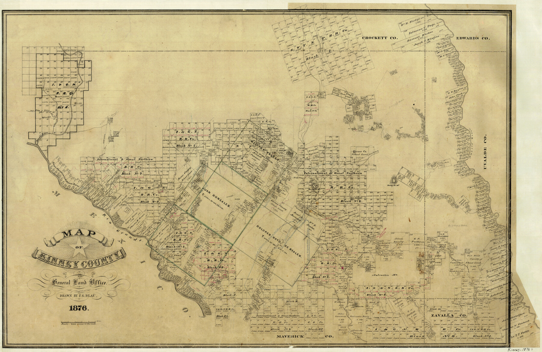
Map of Kinney County
-
Map/Doc
3776
-
Collection
General Map Collection
-
Object Dates
1876 (Creation Date)
-
People and Organizations
F.G. Blau (Draftsman)
-
Counties
Kinney
-
Subjects
County
-
Height x Width
24.8 x 37.8 inches
63.0 x 96.0 cm
-
Features
Turkey Creek
Brackett
Fort Clark
Zoquete Creek
Piedra Pinto Creek
San Pedro Creek
Sacattecosa Creek
Fort Stockton & Fort Clark Road
Fort Stockton Road
Fort Clark Road
Conical Hill
San Felipe
San Felipe Creek
Rio Grande
Stampede Creek
San Antonio Stage Road
[Road] to West Fork of Nueces River
Lindsey Creek
Las Moras Creek
Cow Creek
Salado Creek
Chacon Creek
Sycamore Creek
[Road] to Griffin Valley
Peloncillo [Mountain]
Rusk Trail
Woodhull Creek
Chaparosa Creek
Muela Creek
Gato Creek
Pope Lake [Creek]
Grass Valley Creek
West Prong of Painted Cave Creek
Devil's River
Lone Hill
West Fork of Nueces River
Griffin Creek
E[ast] P[rong] of San Pedro Arroyo
Sienegas Creek
Middle Fork [of Sycamore Creek]
West Fork [of Sycamore Creek]
West Fork [of Xoquete Creek]
West Fork [of Piedra Pinta Creek]
East Fork [of Piedra Pinta Creek]
East Fork [of Xoquete Creek]
Pinto Mountain
Painted Cave Creek
West Prong of Nueces River
Live Oak Creek
Nueces River
Turkey Creek Mountain
Olmos Mountan
Elm Creek
Arenosa Creek
[Road] to Nueces River & Fort McKavett
[Road] to Nueces River
[Road] to Fort McKavett
Las Moras Mountain
Little Pinto Mountain
Bluff Creek
Griffin Valley Creek
Part of: General Map Collection

Carson County Sketch File 1

Print $20.00
- Digital $50.00
Carson County Sketch File 1
Size 16.8 x 18.5 inches
Map/Doc 11053
El Paso County Rolled Sketch 47

Digital $50.00
El Paso County Rolled Sketch 47
Size 41.3 x 90.4 inches
Map/Doc 8874
Irion County Sketch File 7

Print $4.00
- Digital $50.00
Irion County Sketch File 7
1927
Size 11.1 x 7.1 inches
Map/Doc 27471
Coke County Sketch File A

Print $4.00
- Digital $50.00
Coke County Sketch File A
1881
Size 12.5 x 7.0 inches
Map/Doc 18590
Gillespie County Rolled Sketch 3

Print $20.00
- Digital $50.00
Gillespie County Rolled Sketch 3
Size 19.0 x 28.1 inches
Map/Doc 6010
Brewster County Sketch File 44

Print $3.00
- Digital $50.00
Brewster County Sketch File 44
Size 11.5 x 9.4 inches
Map/Doc 16311
Intracoastal Waterway in Texas - Corpus Christi to Point Isabel including Arroyo Colorado to Mo. Pac. R.R. Bridge Near Harlingen

Print $20.00
- Digital $50.00
Intracoastal Waterway in Texas - Corpus Christi to Point Isabel including Arroyo Colorado to Mo. Pac. R.R. Bridge Near Harlingen
1933
Size 40.6 x 28.0 inches
Map/Doc 61877
Borden County Sketch File 2

Print $40.00
- Digital $50.00
Borden County Sketch File 2
Size 19.4 x 10.3 inches
Map/Doc 10932
Brewster County Rolled Sketch 114

Print $20.00
- Digital $50.00
Brewster County Rolled Sketch 114
1964
Size 11.5 x 18.2 inches
Map/Doc 5286
La Salle County Sketch File 5

Print $2.00
- Digital $50.00
La Salle County Sketch File 5
Size 6.9 x 8.9 inches
Map/Doc 29452
Crosby County Working Sketch 5

Print $20.00
- Digital $50.00
Crosby County Working Sketch 5
1911
Size 23.3 x 16.7 inches
Map/Doc 68439
You may also like
Sterling County

Print $20.00
- Digital $50.00
Sterling County
1971
Size 42.8 x 31.1 inches
Map/Doc 77427
The Republic County of Goliad. Proposed, Late Fall 1837

Print $20.00
The Republic County of Goliad. Proposed, Late Fall 1837
2020
Size 15.1 x 21.7 inches
Map/Doc 96147


Flight Mission No. CRK-3P, Frame 176, Refugio County

Print $20.00
- Digital $50.00
Flight Mission No. CRK-3P, Frame 176, Refugio County
1956
Size 18.3 x 22.2 inches
Map/Doc 86923
U.S. Coast and Geodetic First Order Triangulation Stations Geographic Positions Plotted by W.D. Twichell

Digital $50.00
U.S. Coast and Geodetic First Order Triangulation Stations Geographic Positions Plotted by W.D. Twichell
Size 18.0 x 22.7 inches
Map/Doc 92044
Val Verde County Sketch File 7

Print $6.00
- Digital $50.00
Val Verde County Sketch File 7
1877
Size 16.9 x 9.7 inches
Map/Doc 39196
Glasscock County Rolled Sketch 14

Print $20.00
- Digital $50.00
Glasscock County Rolled Sketch 14
1957
Size 29.0 x 26.3 inches
Map/Doc 6020
Cameron County Rolled Sketch 13

Print $40.00
- Digital $50.00
Cameron County Rolled Sketch 13
1952
Size 37.7 x 62.7 inches
Map/Doc 61787
Land Titles Issued in Stephen F. Austin's Colony

Print $20.00
Land Titles Issued in Stephen F. Austin's Colony
2015
Size 30.0 x 24.0 inches
Map/Doc 93754
Rusk County Sketch File 36

Print $20.00
Rusk County Sketch File 36
1950
Size 23.8 x 18.0 inches
Map/Doc 12274
Starr County Sketch File 42

Print $20.00
- Digital $50.00
Starr County Sketch File 42
1941
Size 19.0 x 21.6 inches
Map/Doc 12341