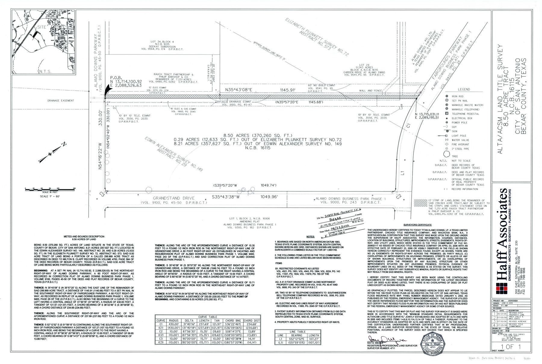
Bexar County State Real Property Sketch 6
ALTA/ACSM Land Title Survey, 8.50 acre tract, N.C.B. 16115, City of San Antonio, Bexar County, Texas
-
Map/Doc
96980
-
Collection
General Map Collection
-
Object Dates
8/22/2022 (File Date)
6/8/2006 (Creation Date)
6/21/2006 (Revision Date)
7/5/2006 (Revision Date)
7/10/2006 (Revision Date)
7/25/2006 (Revision Date)
-
People and Organizations
Ray D. Weger (Surveyor/Engineer)
-
Counties
Bexar
-
Subjects
State Real Property
-
Height x Width
22.2 x 33.1 inches
56.4 x 84.1 cm
-
Medium
mylar, print
-
Scale
1" = 60 feet
Part of: General Map Collection

Flight Mission No. CRC-2R, Frame 120, Chambers County

Print $20.00
- Digital $50.00
Flight Mission No. CRC-2R, Frame 120, Chambers County
1956
Size 18.5 x 22.3 inches
Map/Doc 84744
Map of Matagorda County

Print $20.00
- Digital $50.00
Map of Matagorda County
1839
Size 23.5 x 32.2 inches
Map/Doc 3844
Controlled Mosaic by Jack Amman Photogrammetric Engineers, Inc - Sheet 17

Print $20.00
- Digital $50.00
Controlled Mosaic by Jack Amman Photogrammetric Engineers, Inc - Sheet 17
1954
Size 20.0 x 24.0 inches
Map/Doc 83461
Outer Continental Shelf Leasing Maps (Louisiana Offshore Operations)

Print $20.00
- Digital $50.00
Outer Continental Shelf Leasing Maps (Louisiana Offshore Operations)
1954
Size 13.0 x 15.0 inches
Map/Doc 76111
Starr County Sketch File 10

Print $40.00
- Digital $50.00
Starr County Sketch File 10
Size 12.6 x 15.0 inches
Map/Doc 36863
Old Miscellaneous File 27c

Print $18.00
- Digital $50.00
Old Miscellaneous File 27c
1880
Size 14.1 x 8.6 inches
Map/Doc 75727
Fisher County Rolled Sketch 7

Print $20.00
- Digital $50.00
Fisher County Rolled Sketch 7
2009
Size 28.6 x 24.6 inches
Map/Doc 89988

Galveston County NRC Article 33.136 Sketch 50

Print $24.00
- Digital $50.00
Galveston County NRC Article 33.136 Sketch 50
2008
Size 24.0 x 36.3 inches
Map/Doc 88750
Mills County Working Sketch 25

Print $20.00
- Digital $50.00
Mills County Working Sketch 25
1988
Size 22.0 x 25.1 inches
Map/Doc 71055
Map Showing Location of Dallas & Greenville Railroad through Rockwall County, Texas

Print $3.00
- Digital $50.00
Map Showing Location of Dallas & Greenville Railroad through Rockwall County, Texas
Size 7.9 x 17.5 inches
Map/Doc 64485
You may also like
Motley County Sketch File 12 (N)

Print $3.00
- Digital $50.00
Motley County Sketch File 12 (N)
Size 20.0 x 18.4 inches
Map/Doc 42141
Limestone County Sketch File 28

Print $54.00
- Digital $50.00
Limestone County Sketch File 28
1986
Size 11.2 x 8.5 inches
Map/Doc 30216
Comanche County Working Sketch 16

Print $20.00
- Digital $50.00
Comanche County Working Sketch 16
1969
Size 16.5 x 23.8 inches
Map/Doc 68150
[Sketch Showing Wm. T. Brewer, John R. Taylor, Wm. F. Butler, Timothy DeVore, L. M. Thorn and adjoining surveys]
![89745, [Sketch Showing Wm. T. Brewer, John R. Taylor, Wm. F. Butler, Timothy DeVore, L. M. Thorn and adjoining surveys], Twichell Survey Records](https://historictexasmaps.com/wmedia_w700/maps/89745-1.tif.jpg)
Print $40.00
- Digital $50.00
[Sketch Showing Wm. T. Brewer, John R. Taylor, Wm. F. Butler, Timothy DeVore, L. M. Thorn and adjoining surveys]
Size 37.1 x 56.1 inches
Map/Doc 89745
Galveston County NRC Article 33.136 Sketch 55B

Print $24.00
- Digital $50.00
Galveston County NRC Article 33.136 Sketch 55B
2007
Size 24.0 x 36.0 inches
Map/Doc 94666
Flight Mission No. BRA-16M, Frame 125, Jefferson County

Print $20.00
- Digital $50.00
Flight Mission No. BRA-16M, Frame 125, Jefferson County
1953
Size 18.5 x 22.6 inches
Map/Doc 85735
Deaf Smith County

Print $20.00
- Digital $50.00
Deaf Smith County
1888
Size 28.7 x 19.8 inches
Map/Doc 90598
Flight Mission No. DQN-1K, Frame 70, Calhoun County

Print $20.00
- Digital $50.00
Flight Mission No. DQN-1K, Frame 70, Calhoun County
1953
Size 18.6 x 22.3 inches
Map/Doc 84157
Hardin County Rolled Sketch 15

Print $20.00
- Digital $50.00
Hardin County Rolled Sketch 15
1938
Size 30.9 x 23.7 inches
Map/Doc 6084
Sabine Bank to East Bay including Heald Bank

Print $20.00
- Digital $50.00
Sabine Bank to East Bay including Heald Bank
1971
Size 45.0 x 34.4 inches
Map/Doc 69849
Bird's Eye View of San Antonio, Bexar Co[unty], Texas (Looking North East)
![89204, Bird's Eye View of San Antonio, Bexar Co[unty], Texas (Looking North East), Non-GLO Digital Images](https://historictexasmaps.com/wmedia_w700/maps/89204.tif.jpg)
Print $20.00
Bird's Eye View of San Antonio, Bexar Co[unty], Texas (Looking North East)
1886
Size 21.5 x 28.1 inches
Map/Doc 89204
Wharton County Rolled Sketch 8

Print $20.00
- Digital $50.00
Wharton County Rolled Sketch 8
Size 24.4 x 39.2 inches
Map/Doc 8232