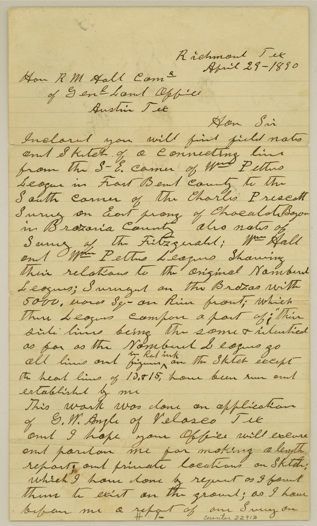
Fort Bend County Sketch File 14
[Explanation and connections by S. M. Farr, Fort Bend County Surveyor]
-
Map/Doc
22913
-
Collection
General Map Collection
-
Object Dates
1890/4/29 (Creation Date)
1890/5/10 (File Date)
-
People and Organizations
S.M. Farr (Surveyor/Engineer)
Eli Thomas (Chainman)
Joe Ford (Chainman)
Gus Williams (Chainman)
-
Counties
Fort Bend Brazoria
-
Subjects
Surveying Sketch File
-
Height x Width
12.3 x 7.4 inches
31.2 x 18.8 cm
-
Medium
paper, manuscript
-
Features
Chocolate Bayou
Oyster Creek
East Prong of Chocolate Bayou
West Prong of Chocolate Bayou
Brazos River
Cow Bayou
Long Point Creek
Indian Slough
Part of: General Map Collection
Old Miscellaneous File 27b

Print $10.00
- Digital $50.00
Old Miscellaneous File 27b
1880
Size 14.3 x 8.8 inches
Map/Doc 75722
Layout of the porciones as described in the Visita General of Camargo, 1767

Layout of the porciones as described in the Visita General of Camargo, 1767
2009
Size 11.0 x 8.5 inches
Map/Doc 94041
Gaines County Rolled Sketch 17

Print $20.00
- Digital $50.00
Gaines County Rolled Sketch 17
1940
Size 24.5 x 17.8 inches
Map/Doc 5934
Bastrop County Sketch File 1a

Print $4.00
- Digital $50.00
Bastrop County Sketch File 1a
Size 8.4 x 12.8 inches
Map/Doc 14040
Dimmit County Rolled Sketch M

Print $20.00
- Digital $50.00
Dimmit County Rolled Sketch M
1936
Size 21.5 x 39.3 inches
Map/Doc 5727
L'Amerique Meridionale, et Septentrionale Dressee selon les derniers Relations et suivant les Nouvelles Decouvertes

Print $20.00
- Digital $50.00
L'Amerique Meridionale, et Septentrionale Dressee selon les derniers Relations et suivant les Nouvelles Decouvertes
1726
Size 18.9 x 24.1 inches
Map/Doc 95134
[Pecos and Northern Texas Ry., Bailey Co., from Parmer Co. line through Lariat and Muleshoe to Lamb Co. line]
![64636, [Pecos and Northern Texas Ry., Bailey Co., from Parmer Co. line through Lariat and Muleshoe to Lamb Co. line], General Map Collection](https://historictexasmaps.com/wmedia_w700/maps/64636.tif.jpg)
Print $40.00
- Digital $50.00
[Pecos and Northern Texas Ry., Bailey Co., from Parmer Co. line through Lariat and Muleshoe to Lamb Co. line]
1912
Size 20.3 x 121.9 inches
Map/Doc 64636
Fort Bend County Rolled Sketch 16

Print $20.00
- Digital $50.00
Fort Bend County Rolled Sketch 16
1890
Size 29.3 x 26.5 inches
Map/Doc 5900
Edwards County Sketch File 26

Print $4.00
- Digital $50.00
Edwards County Sketch File 26
1910
Size 11.5 x 9.2 inches
Map/Doc 21753
Wheeler County Boundary File 1c

Print $4.00
- Digital $50.00
Wheeler County Boundary File 1c
Size 11.4 x 8.9 inches
Map/Doc 59870
Galveston County NRC Article 33.136 Sketch 55A

Print $28.00
- Digital $50.00
Galveston County NRC Article 33.136 Sketch 55A
2009
Size 24.0 x 36.0 inches
Map/Doc 94616
Falls County Boundary File 1

Print $64.00
- Digital $50.00
Falls County Boundary File 1
Size 9.2 x 4.4 inches
Map/Doc 53241
You may also like
Map of Kinney County

Print $20.00
- Digital $50.00
Map of Kinney County
1876
Size 24.0 x 32.4 inches
Map/Doc 3775
Cameron County Rolled Sketch 7

Print $20.00
- Digital $50.00
Cameron County Rolled Sketch 7
1926
Size 27.4 x 31.8 inches
Map/Doc 8563
Taylor County

Print $20.00
- Digital $50.00
Taylor County
1934
Size 42.0 x 36.6 inches
Map/Doc 77432

San Patricio County Working Sketch 12

Print $40.00
- Digital $50.00
San Patricio County Working Sketch 12
Size 51.4 x 40.7 inches
Map/Doc 63774
Live Oak County Sketch File 34

Print $28.00
- Digital $50.00
Live Oak County Sketch File 34
1963
Size 31.0 x 23.9 inches
Map/Doc 12011
Map of Europe to illustrate Olney's school geography (Inset: Central Europe)

Print $20.00
- Digital $50.00
Map of Europe to illustrate Olney's school geography (Inset: Central Europe)
1844
Size 12.1 x 19.0 inches
Map/Doc 93546
Flight Mission No. CUG-1P, Frame 79, Kleberg County

Print $20.00
- Digital $50.00
Flight Mission No. CUG-1P, Frame 79, Kleberg County
1956
Size 18.7 x 22.2 inches
Map/Doc 86144
Flight Mission No. BQY-4M, Frame 39, Harris County

Print $20.00
- Digital $50.00
Flight Mission No. BQY-4M, Frame 39, Harris County
1953
Size 18.6 x 22.3 inches
Map/Doc 85254
Hardeman County Working Sketch 10

Print $20.00
- Digital $50.00
Hardeman County Working Sketch 10
1960
Size 21.9 x 29.9 inches
Map/Doc 63391
Armstrong County Sketch File 2

Print $40.00
- Digital $50.00
Armstrong County Sketch File 2
Size 21.5 x 40.0 inches
Map/Doc 10371
Flight Mission No. CRC-3R, Frame 202, Chambers County

Print $20.00
- Digital $50.00
Flight Mission No. CRC-3R, Frame 202, Chambers County
1956
Size 18.7 x 22.4 inches
Map/Doc 84857