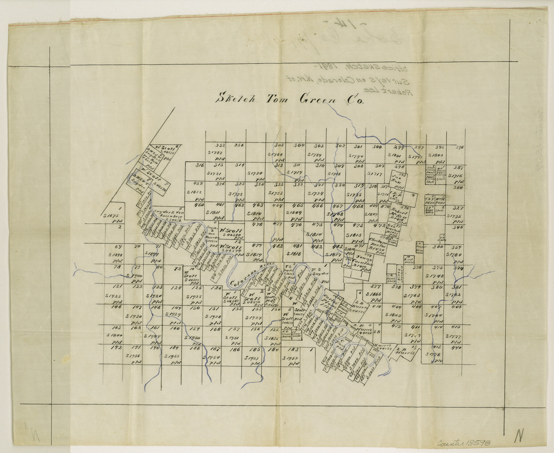
Coke County Sketch File 14
[Office sketch of surveys on the Colorado River and surrounding areas, northwest of Robert Lee]
-
Map/Doc
18598
-
Collection
General Map Collection
-
Object Dates
1891 (Creation Date)
1891 (File Date)
-
Counties
Coke
-
Subjects
Surveying Sketch File
-
Height x Width
10.8 x 13.1 inches
27.4 x 33.3 cm
-
Medium
paper, manuscript
-
Features
Colorado River
Part of: General Map Collection

Scurry County Rolled Sketch 9

Print $20.00
- Digital $50.00
Scurry County Rolled Sketch 9
1963
Size 23.0 x 22.0 inches
Map/Doc 7769
Roberts County Working Sketch 31

Print $20.00
- Digital $50.00
Roberts County Working Sketch 31
1978
Size 26.6 x 22.4 inches
Map/Doc 63557
Upton County Rolled Sketch 25

Print $20.00
- Digital $50.00
Upton County Rolled Sketch 25
1941
Size 33.2 x 34.5 inches
Map/Doc 10044
Sutton County Working Sketch Graphic Index, Sheet 2 (Sketches 25 to Most Recent)

Print $40.00
- Digital $50.00
Sutton County Working Sketch Graphic Index, Sheet 2 (Sketches 25 to Most Recent)
1941
Size 41.2 x 55.2 inches
Map/Doc 76706
Kerr County Working Sketch 2

Print $20.00
- Digital $50.00
Kerr County Working Sketch 2
1926
Size 18.6 x 17.9 inches
Map/Doc 70033
United States Atlantic and Gulf Coasts Including Puerto Rico and the Virgin Islands

Print $40.00
- Digital $50.00
United States Atlantic and Gulf Coasts Including Puerto Rico and the Virgin Islands
1992
Size 21.7 x 60.7 inches
Map/Doc 76123
Houston County Sketch File 27

Print $20.00
- Digital $50.00
Houston County Sketch File 27
Size 18.8 x 21.6 inches
Map/Doc 11788
Hudspeth County Working Sketch 45

Print $20.00
- Digital $50.00
Hudspeth County Working Sketch 45
1983
Size 34.7 x 43.2 inches
Map/Doc 66330
Dickens County Sketch File 6a

Print $6.00
- Digital $50.00
Dickens County Sketch File 6a
1882
Size 16.5 x 9.4 inches
Map/Doc 20969
Orange County Working Sketch 43

Print $20.00
- Digital $50.00
Orange County Working Sketch 43
1980
Size 18.3 x 18.4 inches
Map/Doc 71375
Anderson County Working Sketch 47

Print $40.00
- Digital $50.00
Anderson County Working Sketch 47
2012
Size 49.1 x 37.0 inches
Map/Doc 93396
You may also like
Hutchinson County Sketch File 37

Print $10.00
- Digital $50.00
Hutchinson County Sketch File 37
Size 11.3 x 8.8 inches
Map/Doc 27275
Wendlandt's Subdivision of part of Outlot 4, Division "Z"

Print $20.00
- Digital $50.00
Wendlandt's Subdivision of part of Outlot 4, Division "Z"
1910
Size 17.9 x 13.5 inches
Map/Doc 5041
Map showing Alamo-Donna Farms, Irrigated Section in Hidalgo County, Texas

Print $20.00
- Digital $50.00
Map showing Alamo-Donna Farms, Irrigated Section in Hidalgo County, Texas
1920
Size 27.5 x 13.3 inches
Map/Doc 95803
Wm. H. Bush Estate Resurveyed by W. D. Twichell May 1905

Print $40.00
- Digital $50.00
Wm. H. Bush Estate Resurveyed by W. D. Twichell May 1905
1905
Size 37.1 x 57.7 inches
Map/Doc 89788
Howard County Working Sketch 6

Print $20.00
- Digital $50.00
Howard County Working Sketch 6
1946
Size 17.3 x 19.5 inches
Map/Doc 66272
Webb County Sketch File 44b

Print $8.00
- Digital $50.00
Webb County Sketch File 44b
1936
Size 14.5 x 9.0 inches
Map/Doc 39829
Pecos County Working Sketch 118

Print $20.00
- Digital $50.00
Pecos County Working Sketch 118
1973
Size 46.2 x 36.9 inches
Map/Doc 71591
Corpus Christi Pass

Print $20.00
- Digital $50.00
Corpus Christi Pass
Size 46.2 x 41.4 inches
Map/Doc 78455
Tarrant County Working Sketch 6

Print $20.00
- Digital $50.00
Tarrant County Working Sketch 6
1979
Size 29.3 x 18.7 inches
Map/Doc 62423
Stephens County Sketch File 2

Print $4.00
- Digital $50.00
Stephens County Sketch File 2
1870
Size 12.9 x 8.2 inches
Map/Doc 37013
Taylor County Working Sketch 21

Print $40.00
- Digital $50.00
Taylor County Working Sketch 21
1985
Size 55.9 x 43.8 inches
Map/Doc 69631
Ector County Working Sketch Graphic Index - sheet A

Print $20.00
- Digital $50.00
Ector County Working Sketch Graphic Index - sheet A
1943
Size 44.5 x 39.1 inches
Map/Doc 76530