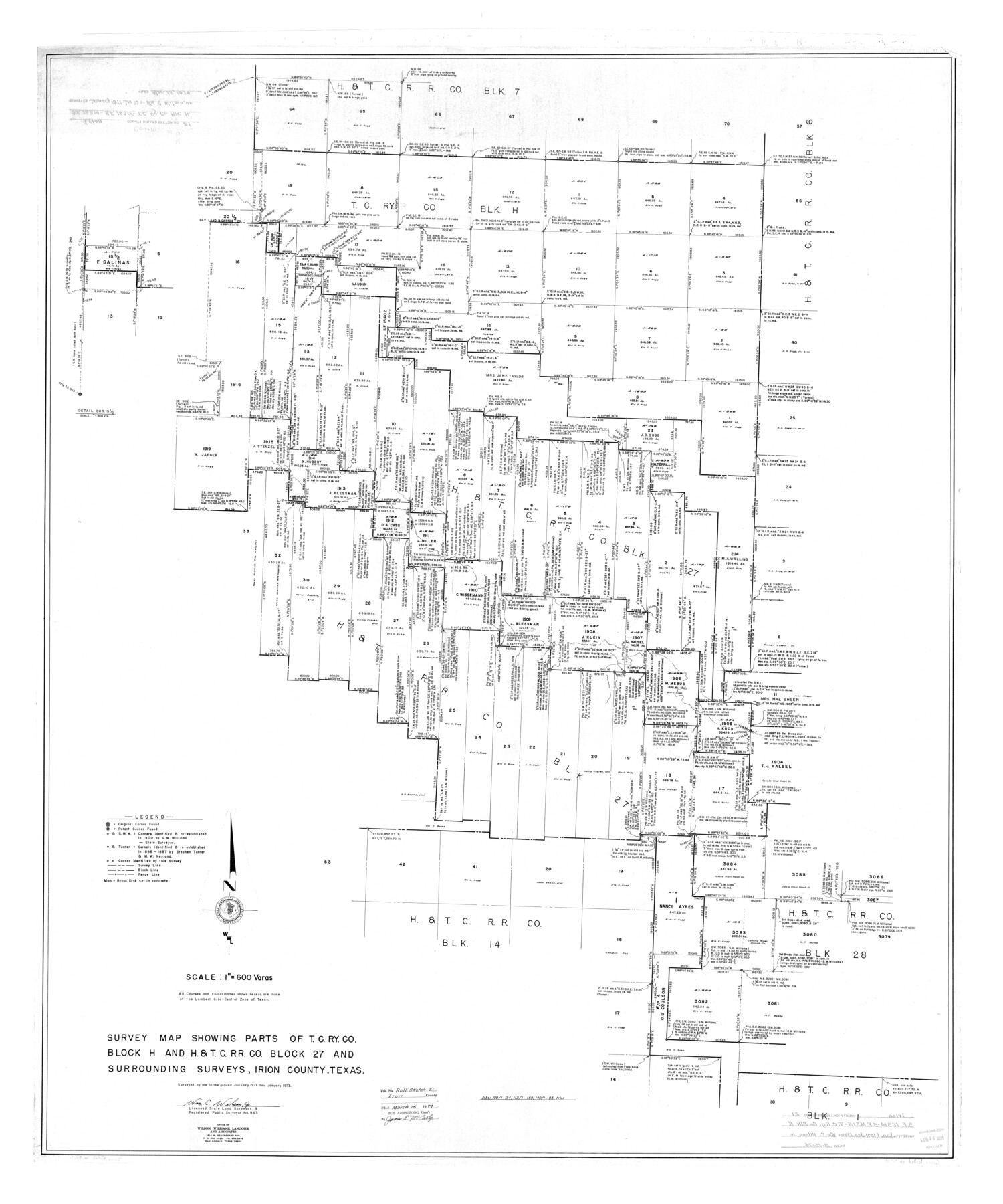
Irion County Rolled Sketch 21
Survey map showing parts of T. C. Ry. Co. Block H and H. & T. C. R.R. Co. Block 27 and surrounding surveys, Irion County, Texas
-
Map/Doc
9256
-
Collection
General Map Collection
-
Object Dates
1973 (Survey Date)
1974/3/15 (File Date)
-
People and Organizations
Wm. C. Wilson, Jr. (Surveyor/Engineer)
-
Counties
Irion
-
Subjects
Surveying Rolled Sketch
-
Height x Width
52.8 x 44.0 inches
134.1 x 111.8 cm
-
Scale
1" = 600 varas
Part of: General Map Collection
Runnels County Working Sketch 1

Print $20.00
- Digital $50.00
Runnels County Working Sketch 1
Size 15.9 x 14.4 inches
Map/Doc 63597
Travis County Sketch File 37

Print $4.00
- Digital $50.00
Travis County Sketch File 37
Size 8.2 x 10.1 inches
Map/Doc 38357
Flight Mission No. DAG-24K, Frame 138, Matagorda County

Print $20.00
- Digital $50.00
Flight Mission No. DAG-24K, Frame 138, Matagorda County
1953
Size 18.4 x 15.8 inches
Map/Doc 86556
Crosby County Boundary File 1a

Print $32.00
- Digital $50.00
Crosby County Boundary File 1a
Size 12.8 x 8.1 inches
Map/Doc 51981
Map of Uvalde County

Print $20.00
- Digital $50.00
Map of Uvalde County
1862
Size 27.4 x 20.7 inches
Map/Doc 4109
Harris County Historic Topographic 21

Print $20.00
- Digital $50.00
Harris County Historic Topographic 21
1915
Size 29.2 x 22.5 inches
Map/Doc 65832
Kinney County Working Sketch 34

Print $20.00
- Digital $50.00
Kinney County Working Sketch 34
1963
Size 23.0 x 26.9 inches
Map/Doc 70216
Pecos County Working Sketch 118

Print $20.00
- Digital $50.00
Pecos County Working Sketch 118
1973
Size 46.2 x 36.9 inches
Map/Doc 71591
Texas Official Highway Travel Map

Digital $50.00
Texas Official Highway Travel Map
Size 27.2 x 36.2 inches
Map/Doc 94305
Cameron County Sketch File 17

Print $24.00
- Digital $50.00
Cameron County Sketch File 17
2009
Size 11.0 x 8.5 inches
Map/Doc 95191
North Part of El Paso Co.

Print $20.00
- Digital $50.00
North Part of El Paso Co.
1977
Size 35.7 x 46.3 inches
Map/Doc 73141
You may also like
Chambers County Working Sketch 14

Print $20.00
- Digital $50.00
Chambers County Working Sketch 14
1957
Size 30.3 x 19.0 inches
Map/Doc 67997
St. Louis, Brownsville & Mexico Railway Location Map from Mile 0 to Mile 20

Print $40.00
- Digital $50.00
St. Louis, Brownsville & Mexico Railway Location Map from Mile 0 to Mile 20
1906
Size 19.3 x 57.7 inches
Map/Doc 64076
Anderson County Working Sketch 5

Print $20.00
- Digital $50.00
Anderson County Working Sketch 5
1913
Size 15.0 x 15.3 inches
Map/Doc 67004
Burlington Route

Print $20.00
- Digital $50.00
Burlington Route
1892
Size 34.9 x 47.7 inches
Map/Doc 93910
Engineer map showing engineer information at 23 O'Clock 23 Oct. 1918 drawn under direction of Col. W.A. Mitchell - Verso

Print $20.00
Engineer map showing engineer information at 23 O'Clock 23 Oct. 1918 drawn under direction of Col. W.A. Mitchell - Verso
1918
Size 19.7 x 12.6 inches
Map/Doc 94128
Map of Nacogdoches County

Print $40.00
- Digital $50.00
Map of Nacogdoches County
1839
Size 83.6 x 41.6 inches
Map/Doc 93371
General Highway Map, Tyler County, Texas

Print $20.00
General Highway Map, Tyler County, Texas
1961
Size 24.8 x 18.1 inches
Map/Doc 79690
[Block 3 on East side of County]
![90606, [Block 3 on East side of County], Twichell Survey Records](https://historictexasmaps.com/wmedia_w700/maps/90606-1.tif.jpg)
Print $20.00
- Digital $50.00
[Block 3 on East side of County]
Size 16.9 x 19.8 inches
Map/Doc 90606
Brazoria County NRC Article 33.136 Sketch 1

Print $20.00
- Digital $50.00
Brazoria County NRC Article 33.136 Sketch 1
2000
Size 24.7 x 35.9 inches
Map/Doc 61555
Flight Mission No. CRC-4R, Frame 82, Chambers County

Print $20.00
- Digital $50.00
Flight Mission No. CRC-4R, Frame 82, Chambers County
1956
Size 18.7 x 22.6 inches
Map/Doc 84886
Liberty County Sketch File 24

Print $6.00
- Digital $50.00
Liberty County Sketch File 24
Size 10.2 x 7.9 inches
Map/Doc 29936
Kinney County Working Sketch 53

Print $20.00
- Digital $50.00
Kinney County Working Sketch 53
1981
Size 23.7 x 23.0 inches
Map/Doc 70235