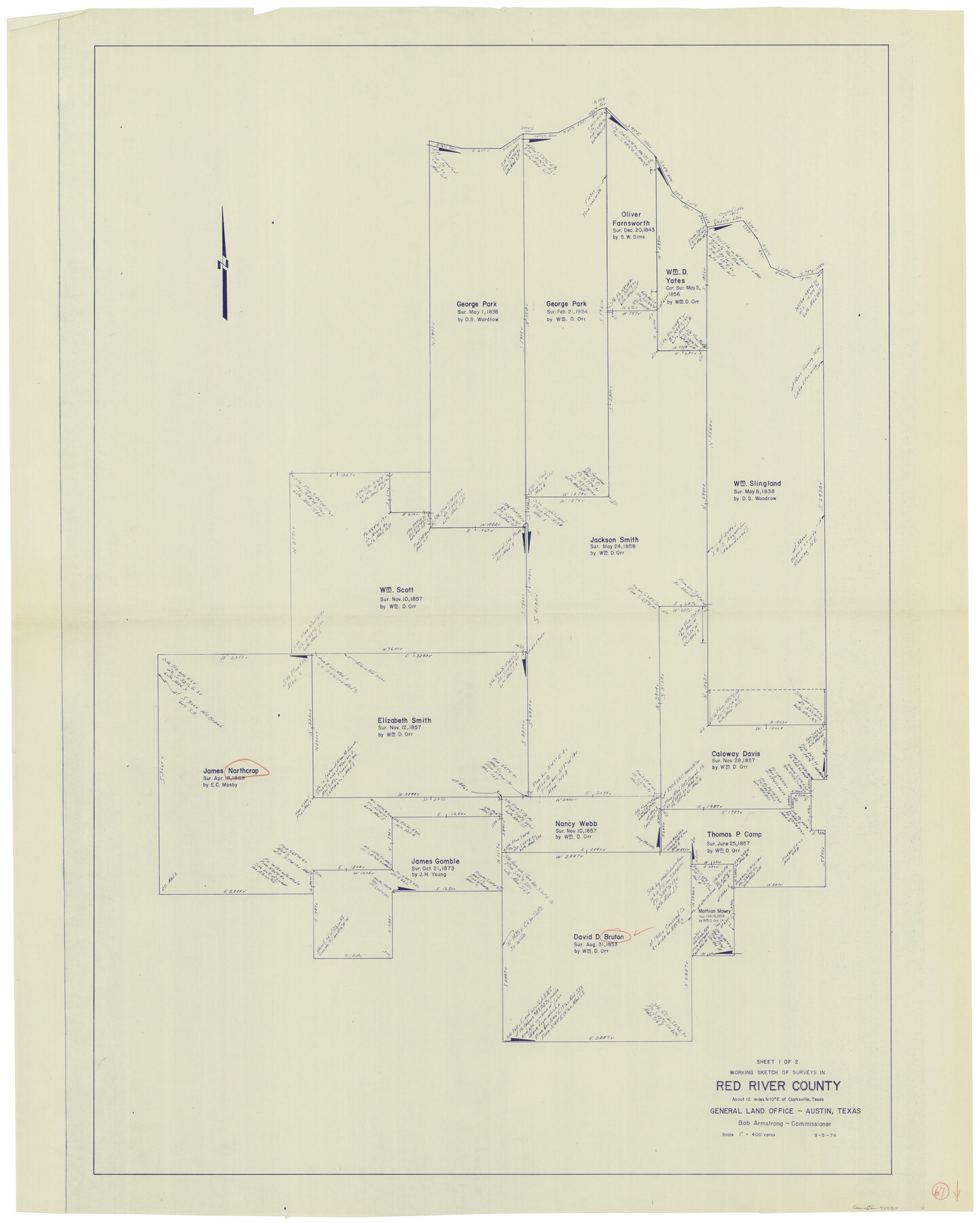
Red River County Working Sketch 67
-
Map/Doc
72050
-
Collection
General Map Collection
-
Object Dates
8/5/1974 (Creation Date)
-
Counties
Red River
-
Subjects
Surveying Working Sketch
-
Height x Width
46.9 x 37.7 inches
119.1 x 95.8 cm
-
Scale
1" = 400 varas
Part of: General Map Collection
Hansford County Boundary File 2a

Print $40.00
- Digital $50.00
Hansford County Boundary File 2a
Size 14.2 x 8.7 inches
Map/Doc 54252
Upton County Rolled Sketch 57

Print $20.00
- Digital $50.00
Upton County Rolled Sketch 57
Size 30.1 x 41.8 inches
Map/Doc 8090
Brazoria County NRC Article 33.136 Sketch 2

Print $20.00
- Digital $50.00
Brazoria County NRC Article 33.136 Sketch 2
2002
Size 40.6 x 29.7 inches
Map/Doc 77038
Henderson County Rolled Sketch 1

Print $20.00
- Digital $50.00
Henderson County Rolled Sketch 1
1942
Size 34.0 x 38.3 inches
Map/Doc 9159
Presidio County Working Sketch 133

Print $20.00
- Digital $50.00
Presidio County Working Sketch 133
1989
Size 31.7 x 42.8 inches
Map/Doc 71811
Flight Mission No. BRA-16M, Frame 131, Jefferson County

Print $20.00
- Digital $50.00
Flight Mission No. BRA-16M, Frame 131, Jefferson County
1953
Size 18.4 x 22.5 inches
Map/Doc 85741
Presidio County Working Sketch 24

Print $20.00
- Digital $50.00
Presidio County Working Sketch 24
1945
Size 18.0 x 11.9 inches
Map/Doc 71700

Flight Mission No. CGI-1N, Frame 174, Cameron County

Print $20.00
- Digital $50.00
Flight Mission No. CGI-1N, Frame 174, Cameron County
1955
Size 18.5 x 22.1 inches
Map/Doc 84509
Cass County Working Sketch 29

Print $20.00
- Digital $50.00
Cass County Working Sketch 29
1979
Size 38.4 x 23.5 inches
Map/Doc 67932
[Surveys in Austin's Colony along New Year's Creek and the Navidad River]
![212, [Surveys in Austin's Colony along New Year's Creek and the Navidad River], General Map Collection](https://historictexasmaps.com/wmedia_w700/maps/212.tif.jpg)
Print $20.00
- Digital $50.00
[Surveys in Austin's Colony along New Year's Creek and the Navidad River]
Size 20.2 x 15.6 inches
Map/Doc 212
Mitchell County Working Sketch 7

Print $20.00
- Digital $50.00
Mitchell County Working Sketch 7
1963
Size 38.6 x 22.6 inches
Map/Doc 71064
You may also like
Sketch showing progress of topographical work Laguna Madre and vicinity from Rainey Is. to Baffins Bay, Coast of Texas Sect. IX [and accompanying letter]
![72958, Sketch showing progress of topographical work Laguna Madre and vicinity from Rainey Is. to Baffins Bay, Coast of Texas Sect. IX [and accompanying letter], General Map Collection](https://historictexasmaps.com/wmedia_w700/maps/72958.tif.jpg)
Print $2.00
- Digital $50.00
Sketch showing progress of topographical work Laguna Madre and vicinity from Rainey Is. to Baffins Bay, Coast of Texas Sect. IX [and accompanying letter]
1881
Size 11.2 x 8.8 inches
Map/Doc 72958
Matagorda County NRC Article 33.136 Sketch 3

Print $20.00
- Digital $50.00
Matagorda County NRC Article 33.136 Sketch 3
2008
Size 36.0 x 24.0 inches
Map/Doc 88834
Jasper County Working Sketch 29

Print $20.00
- Digital $50.00
Jasper County Working Sketch 29
1956
Size 20.6 x 31.4 inches
Map/Doc 66491
[Sketch Showing Blocks in Hansford County, Texas]
![75819, [Sketch Showing Blocks in Hansford County, Texas], Maddox Collection](https://historictexasmaps.com/wmedia_w700/maps/75819.tif.jpg)
Print $20.00
- Digital $50.00
[Sketch Showing Blocks in Hansford County, Texas]
1890
Size 34.1 x 25.3 inches
Map/Doc 75819
[Sketch showing Panhandle and Santa Fe Railroad, Compress Spur and Seed House structures]
![92880, [Sketch showing Panhandle and Santa Fe Railroad, Compress Spur and Seed House structures], Twichell Survey Records](https://historictexasmaps.com/wmedia_w700/maps/92880-1.tif.jpg)
Print $20.00
- Digital $50.00
[Sketch showing Panhandle and Santa Fe Railroad, Compress Spur and Seed House structures]
Size 20.8 x 22.8 inches
Map/Doc 92880
Louisiana and Texas Intracoastal Waterway - Sabine River-Galveston Bay Section, Steel Sheet Pile Dyke at Galveston Bay Entrance

Print $20.00
- Digital $50.00
Louisiana and Texas Intracoastal Waterway - Sabine River-Galveston Bay Section, Steel Sheet Pile Dyke at Galveston Bay Entrance
1933
Size 31.4 x 40.9 inches
Map/Doc 61818
Moore County Boundary File 1

Print $42.00
- Digital $50.00
Moore County Boundary File 1
Size 8.9 x 3.8 inches
Map/Doc 57452
![94158, Austin Street Map [Recto], General Map Collection](https://historictexasmaps.com/wmedia_w700/maps/94158.tif.jpg)

Deaf Smith County Sketch File 7

Print $4.00
- Digital $50.00
Deaf Smith County Sketch File 7
1917
Size 11.3 x 9.0 inches
Map/Doc 20664
Trinity County Boundary File 102

Print $14.00
- Digital $50.00
Trinity County Boundary File 102
Size 9.2 x 4.6 inches
Map/Doc 59480
North America

Print $20.00
- Digital $50.00
North America
1823
Size 21.9 x 25.6 inches
Map/Doc 93842