![75819, [Sketch Showing Blocks in Hansford County, Texas], Maddox Collection](https://historictexasmaps.com/wmedia_w1800h1800/maps/75819.tif.jpg)
[Sketch Showing Blocks in Hansford County, Texas]
-
Map/Doc
75819
-
Collection
Maddox Collection
-
Object Dates
1890/10/3 (Creation Date)
1890/10/3 (File Date)
-
People and Organizations
Jas. L. Gray (Surveyor/Engineer)
E. von Rosenberg (Draftsman)
-
Counties
Hansford Hutchinson
-
Height x Width
34.1 x 25.3 inches
86.6 x 64.3 cm
-
Medium
blueprint/diazo
-
Features
Coldwater Creek
Palo Duro Creek
McCrea
Cater Ranch
Cranmer Ranch
Bigger Ranch
Part of: Maddox Collection
Frio County, Texas

Print $20.00
- Digital $50.00
Frio County, Texas
1870
Size 20.9 x 21.3 inches
Map/Doc 729
Map of the C.C. Browning survey 412 enlarged from General Land Office map of the west part of Travis County, Texas

Print $3.00
- Digital $50.00
Map of the C.C. Browning survey 412 enlarged from General Land Office map of the west part of Travis County, Texas
1920
Size 11.3 x 9.1 inches
Map/Doc 10752
Palo Pinto County, Texas

Print $20.00
- Digital $50.00
Palo Pinto County, Texas
1871
Size 28.8 x 23.4 inches
Map/Doc 660
Callahan County, Texas

Print $20.00
- Digital $50.00
Callahan County, Texas
1880
Size 24.1 x 18.5 inches
Map/Doc 89276
[Pecos County Sketch]
![444, [Pecos County Sketch], Maddox Collection](https://historictexasmaps.com/wmedia_w700/maps/444.tif.jpg)
Print $20.00
- Digital $50.00
[Pecos County Sketch]
1880
Size 38.5 x 31.3 inches
Map/Doc 444
Map of Lands in King County, Texas owned and leased by the Louisville Land and Cattle Company

Print $20.00
- Digital $50.00
Map of Lands in King County, Texas owned and leased by the Louisville Land and Cattle Company
Size 32.1 x 25.9 inches
Map/Doc 5070
Sketch in Uvalde County

Print $20.00
- Digital $50.00
Sketch in Uvalde County
1890
Size 13.3 x 15.9 inches
Map/Doc 650
Haskell County
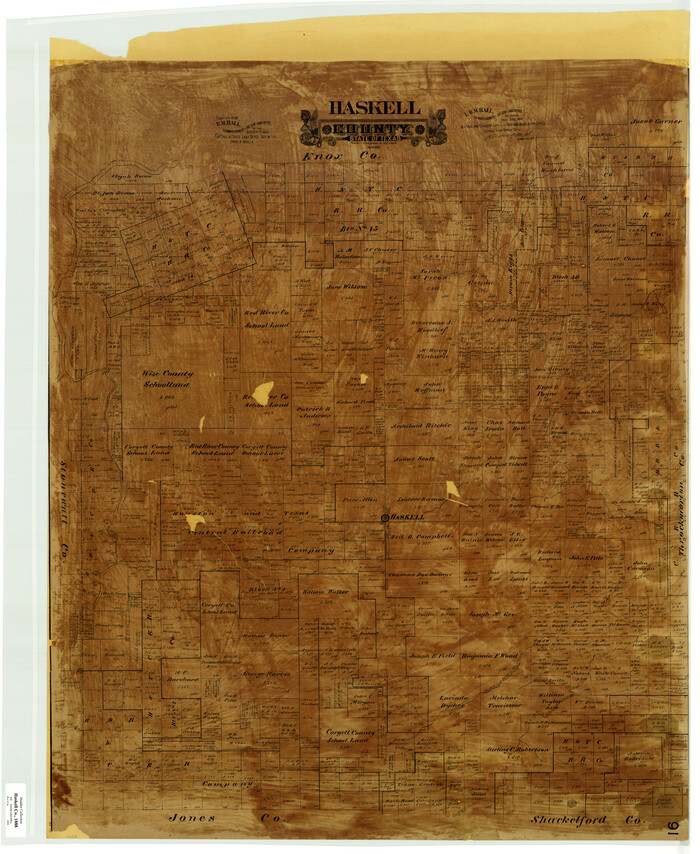
Print $20.00
- Digital $50.00
Haskell County
1888
Size 41.4 x 33.9 inches
Map/Doc 399
[Block A, Greer County, Texas]
![384, [Block A, Greer County, Texas], Maddox Collection](https://historictexasmaps.com/wmedia_w700/maps/384.tif.jpg)
Print $20.00
- Digital $50.00
[Block A, Greer County, Texas]
Size 16.9 x 15.8 inches
Map/Doc 384
Map of lands owned by R.E. Montgomery in Martin and Andrews County, Texas

Print $20.00
- Digital $50.00
Map of lands owned by R.E. Montgomery in Martin and Andrews County, Texas
Size 20.0 x 24.5 inches
Map/Doc 75764
Showing how the New County of Durant is bounded, from Official Maps from the General Land Office of Galveston, Harris, Fort Bend, and Brazoria Counties

Print $20.00
- Digital $50.00
Showing how the New County of Durant is bounded, from Official Maps from the General Land Office of Galveston, Harris, Fort Bend, and Brazoria Counties
1880
Size 18.6 x 19.0 inches
Map/Doc 4473
Survey of Lots 1, 2, 3, 4 and 5, Block 12G Fair View Park, Austin Texas

Print $20.00
- Digital $50.00
Survey of Lots 1, 2, 3, 4 and 5, Block 12G Fair View Park, Austin Texas
1914
Size 10.7 x 22.8 inches
Map/Doc 472
You may also like
Montgomery County Working Sketch 6

Print $20.00
- Digital $50.00
Montgomery County Working Sketch 6
1932
Size 24.8 x 32.2 inches
Map/Doc 71112
Crane County Working Sketch Graphic Index, Sheet A

Print $20.00
- Digital $50.00
Crane County Working Sketch Graphic Index, Sheet A
1945
Size 44.6 x 33.3 inches
Map/Doc 76507
Flight Mission No. DAG-24K, Frame 151, Matagorda County

Print $20.00
- Digital $50.00
Flight Mission No. DAG-24K, Frame 151, Matagorda County
1953
Size 18.5 x 22.1 inches
Map/Doc 86565
Flight Mission No. BRA-7M, Frame 127, Jefferson County

Print $20.00
- Digital $50.00
Flight Mission No. BRA-7M, Frame 127, Jefferson County
1953
Size 18.5 x 22.3 inches
Map/Doc 85521
Outer Continental Shelf Leasing Maps (Louisiana Offshore Operations)

Print $20.00
- Digital $50.00
Outer Continental Shelf Leasing Maps (Louisiana Offshore Operations)
1955
Size 9.7 x 11.3 inches
Map/Doc 76089
Concho County Sketch File 37

Print $20.00
- Digital $50.00
Concho County Sketch File 37
1938
Size 18.7 x 29.1 inches
Map/Doc 11162
Seagraves Chamber of Commerce Subdivision of Northeast Quarter of Southeast Quarter of Section 9, Block C-34, Gaines County, Texas

Print $20.00
- Digital $50.00
Seagraves Chamber of Commerce Subdivision of Northeast Quarter of Southeast Quarter of Section 9, Block C-34, Gaines County, Texas
1955
Size 16.7 x 18.2 inches
Map/Doc 92684
King County Working Sketch 7

Print $20.00
- Digital $50.00
King County Working Sketch 7
1952
Size 34.7 x 24.9 inches
Map/Doc 70171
Kimble County Working Sketch 25

Print $20.00
- Digital $50.00
Kimble County Working Sketch 25
1937
Size 22.9 x 22.7 inches
Map/Doc 70093
Flight Mission No. BQR-13K, Frame 22, Brazoria County

Print $20.00
- Digital $50.00
Flight Mission No. BQR-13K, Frame 22, Brazoria County
1952
Size 18.9 x 22.4 inches
Map/Doc 84070
Map of Harrison County

Print $20.00
- Digital $50.00
Map of Harrison County
1840
Size 44.6 x 34.5 inches
Map/Doc 1515
Kimble County Sketch File 40

Print $14.00
- Digital $50.00
Kimble County Sketch File 40
1888
Size 10.8 x 8.6 inches
Map/Doc 29003