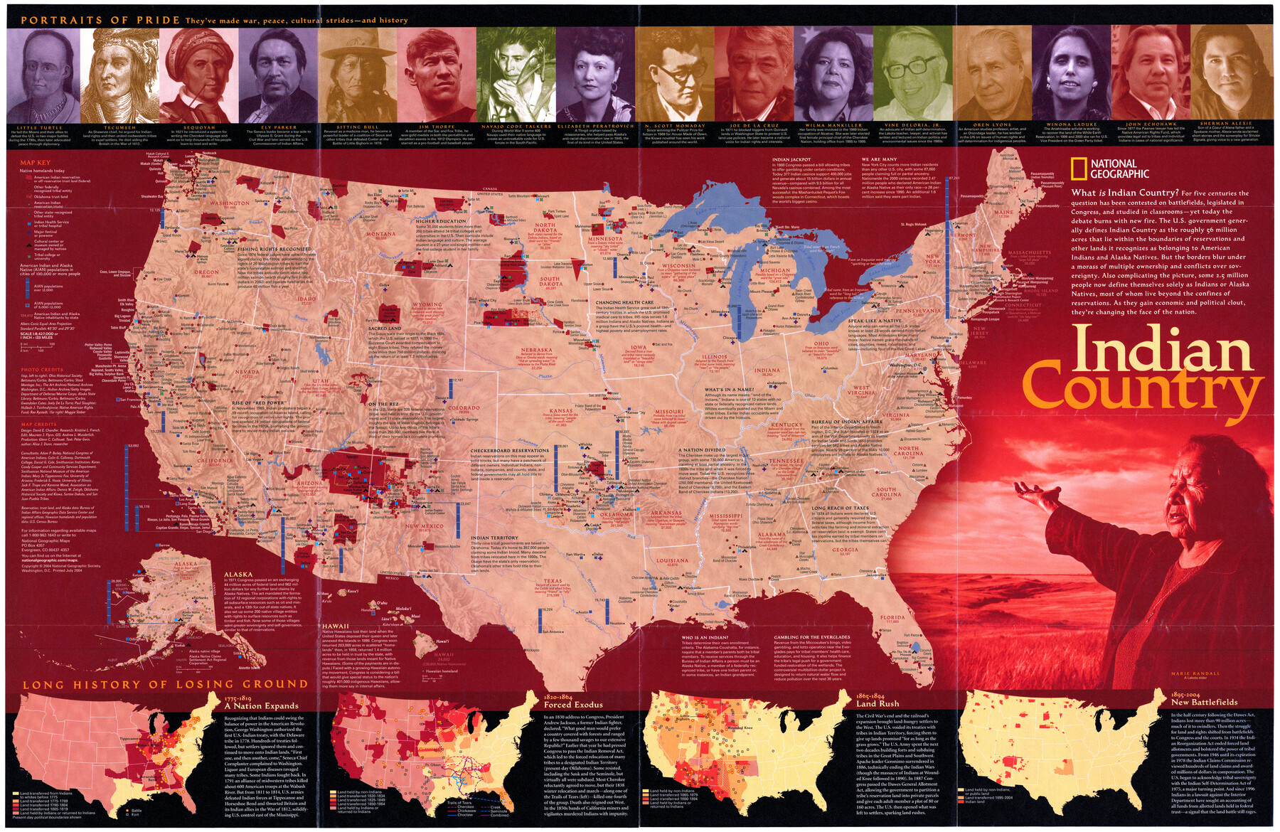
Indian Country
-
Map/Doc
95928
-
Collection
General Map Collection
-
Object Dates
2004 (Publication Date)
-
People and Organizations
National Geographic Society (Publisher)
Mark Lambert (Donor)
-
Subjects
Pictorial United States
-
Height x Width
20.3 x 31.2 inches
51.6 x 79.3 cm
-
Medium
paper, print
-
Comments
For research only. Donated by Mark Lambert in August, 2020. See 95927 for recto.
Related maps

Part of: General Map Collection
Jackson County Sketch File 12

Print $20.00
- Digital $50.00
Jackson County Sketch File 12
1907
Size 12.3 x 20.7 inches
Map/Doc 11838

Padre Island National Seashore

Print $4.00
- Digital $50.00
Padre Island National Seashore
Size 16.1 x 22.3 inches
Map/Doc 60538
Map of sections 1 & 2 of a survey of Padre Island made for the Office of the Attorney General of the State of Texas

Print $20.00
- Digital $50.00
Map of sections 1 & 2 of a survey of Padre Island made for the Office of the Attorney General of the State of Texas
1941
Size 40.8 x 39.8 inches
Map/Doc 2258
Williamson County

Print $40.00
- Digital $50.00
Williamson County
1946
Size 40.1 x 57.7 inches
Map/Doc 63130

Flight Mission No. CGI-3N, Frame 47, Cameron County

Print $20.00
- Digital $50.00
Flight Mission No. CGI-3N, Frame 47, Cameron County
1954
Size 18.7 x 22.3 inches
Map/Doc 84553
Bosque County Sketch File 20

Print $4.00
- Digital $50.00
Bosque County Sketch File 20
1863
Size 11.8 x 7.7 inches
Map/Doc 14796
Rockwall County Sketch File 3

Print $6.00
Rockwall County Sketch File 3
1851
Size 17.2 x 11.6 inches
Map/Doc 35417

Flight Mission No. BQR-13K, Frame 121, Brazoria County

Print $20.00
- Digital $50.00
Flight Mission No. BQR-13K, Frame 121, Brazoria County
1952
Size 18.6 x 22.3 inches
Map/Doc 84082
[Surveys along Childress Creek in Bosque County]
![69759, [Surveys along Childress Creek in Bosque County], General Map Collection](https://historictexasmaps.com/wmedia_w700/maps/69759.tif.jpg)
Print $2.00
- Digital $50.00
[Surveys along Childress Creek in Bosque County]
1846
Size 11.6 x 8.5 inches
Map/Doc 69759
You may also like
Galveston County NRC Article 33.136 Sketch 97

Print $414.00
Galveston County NRC Article 33.136 Sketch 97
2024
Map/Doc 97407
Map of Burnet Co.

Print $20.00
- Digital $50.00
Map of Burnet Co.
1887
Size 45.5 x 37.9 inches
Map/Doc 7816
Duval County Rolled Sketch 11

Print $20.00
- Digital $50.00
Duval County Rolled Sketch 11
Size 20.4 x 30.1 inches
Map/Doc 5733
Crosby County Sketch File 16

Print $20.00
- Digital $50.00
Crosby County Sketch File 16
1904
Size 31.7 x 9.6 inches
Map/Doc 11251
Jones County Sketch File 10

Print $20.00
- Digital $50.00
Jones County Sketch File 10
1875
Size 14.3 x 22.2 inches
Map/Doc 11900
Stephens County Sketch File 8

Print $40.00
- Digital $50.00
Stephens County Sketch File 8
1879
Size 13.5 x 14.2 inches
Map/Doc 37027
Erath County Working Sketch 28

Print $20.00
- Digital $50.00
Erath County Working Sketch 28
1970
Size 31.8 x 31.6 inches
Map/Doc 69109
Rockwall County Working Sketch 2

Print $20.00
- Digital $50.00
Rockwall County Working Sketch 2
1923
Size 20.9 x 16.8 inches
Map/Doc 63594
Tom Green County Sketch File 86

Print $8.00
- Digital $50.00
Tom Green County Sketch File 86
1986
Size 14.2 x 8.9 inches
Map/Doc 38260
Upshur County Sketch File 22

Print $8.00
- Digital $50.00
Upshur County Sketch File 22
2015
Size 11.0 x 8.5 inches
Map/Doc 93774
Stephens County Working Sketch 19

Print $40.00
- Digital $50.00
Stephens County Working Sketch 19
1969
Size 48.8 x 42.7 inches
Map/Doc 63962
Williamson County Sketch File 3

Print $24.00
- Digital $50.00
Williamson County Sketch File 3
1853
Size 13.0 x 8.2 inches
Map/Doc 40301