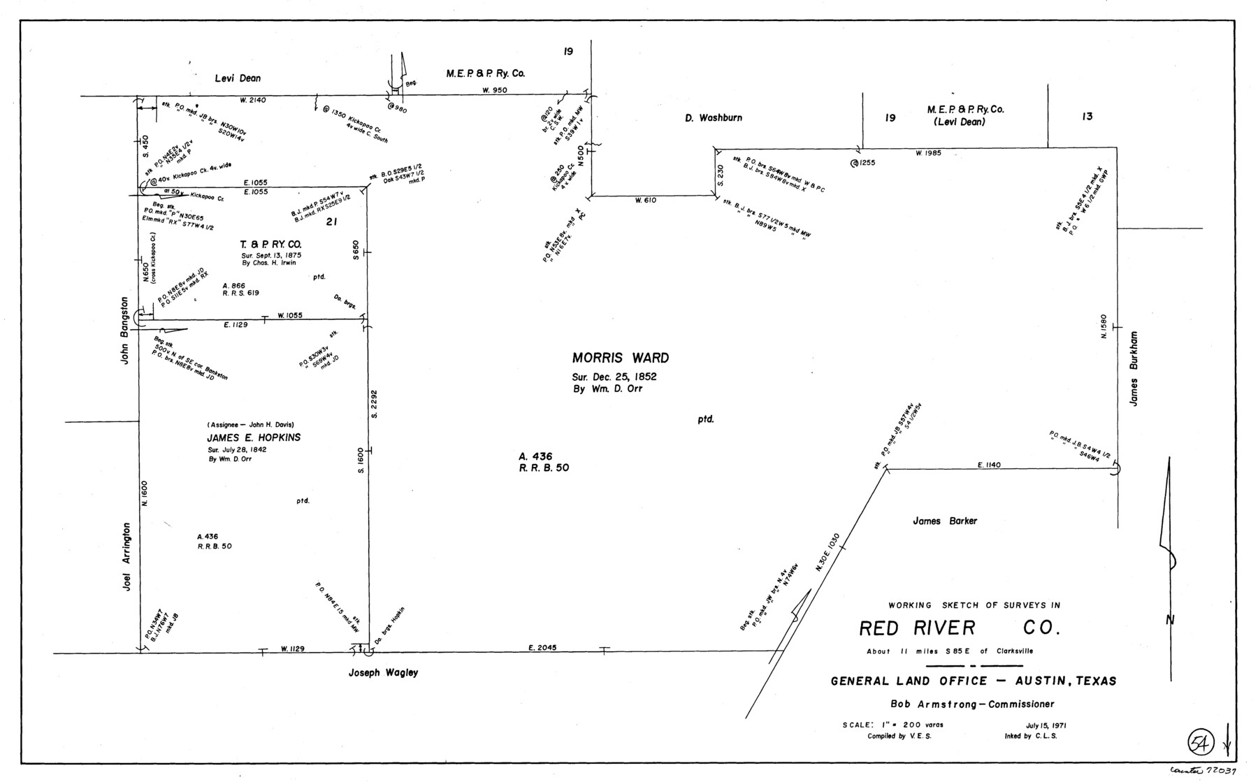
Red River County Working Sketch 54
-
Map/Doc
72037
-
Collection
General Map Collection
-
Object Dates
7/15/1971 (Creation Date)
-
People and Organizations
Victor E. Sterzing (Compiler)
Crockett L. Slover (Inker)
-
Counties
Red River
-
Subjects
Surveying Working Sketch
-
Height x Width
19.3 x 31.1 inches
49.0 x 79.0 cm
-
Scale
1" = 200 varas
Part of: General Map Collection
Matagorda County Boundary File 1a

Print $8.00
- Digital $50.00
Matagorda County Boundary File 1a
Size 14.2 x 8.6 inches
Map/Doc 56889
Flight Mission No. BQY-4M, Frame 124, Harris County

Print $20.00
- Digital $50.00
Flight Mission No. BQY-4M, Frame 124, Harris County
1953
Size 18.7 x 22.4 inches
Map/Doc 85292
Upton County Working Sketch 10

Print $20.00
- Digital $50.00
Upton County Working Sketch 10
1926
Size 28.1 x 30.6 inches
Map/Doc 69506
Jefferson County Working Sketch 8

Print $20.00
- Digital $50.00
Jefferson County Working Sketch 8
1931
Size 34.9 x 18.2 inches
Map/Doc 66551
Lynn County Rolled Sketch 12

Print $20.00
- Digital $50.00
Lynn County Rolled Sketch 12
1956
Size 35.0 x 24.5 inches
Map/Doc 6648
Reeves County Rolled Sketch 5

Print $20.00
- Digital $50.00
Reeves County Rolled Sketch 5
Size 34.7 x 28.0 inches
Map/Doc 7477
Harris County Working Sketch 25

Print $20.00
- Digital $50.00
Harris County Working Sketch 25
1928
Size 26.7 x 24.3 inches
Map/Doc 65917
Pecos County Sketch File 30

Print $20.00
- Digital $50.00
Pecos County Sketch File 30
Size 28.9 x 22.0 inches
Map/Doc 12172
Upton County Working Sketch 4

Print $20.00
- Digital $50.00
Upton County Working Sketch 4
Size 21.8 x 33.9 inches
Map/Doc 69500
Leon County Sketch File 3

Print $4.00
- Digital $50.00
Leon County Sketch File 3
Size 12.4 x 7.9 inches
Map/Doc 29713
Rusk County Sketch File 43

Print $20.00
Rusk County Sketch File 43
1951
Size 23.5 x 26.6 inches
Map/Doc 12278
Flight Mission No. BQY-4M, Frame 64, Harris County

Print $20.00
- Digital $50.00
Flight Mission No. BQY-4M, Frame 64, Harris County
1953
Size 18.6 x 22.5 inches
Map/Doc 85273
You may also like
Hill County Sketch File 18

Print $26.00
- Digital $50.00
Hill County Sketch File 18
1852
Size 8.6 x 4.9 inches
Map/Doc 26486
Nueces County Sketch File 49

Print $20.00
- Digital $50.00
Nueces County Sketch File 49
1956
Size 32.4 x 17.1 inches
Map/Doc 42193
Right of Way and Track Map, The Wichita Falls & Southern Railway

Print $40.00
- Digital $50.00
Right of Way and Track Map, The Wichita Falls & Southern Railway
1942
Size 25.0 x 121.0 inches
Map/Doc 64512

Culberson County Rolled Sketch 60

Print $46.00
- Digital $50.00
Culberson County Rolled Sketch 60
1968
Size 58.9 x 31.3 inches
Map/Doc 8761
Reference Book of Burnet's, [Vehlein's] & Zavala's Colonies
![94554, Reference Book of Burnet's, [Vehlein's] & Zavala's Colonies, Historical Volumes](https://historictexasmaps.com/wmedia_w700/pdf_converted_jpg/qi_pdf_thumbnail_39143.jpg)
Reference Book of Burnet's, [Vehlein's] & Zavala's Colonies
Map/Doc 94554
Jeff Davis County Sketch File 18

Print $71.00
- Digital $50.00
Jeff Davis County Sketch File 18
Size 9.7 x 12.9 inches
Map/Doc 27951
The Judicial District/County of Waco. Created, January 29, 1842

Print $20.00
The Judicial District/County of Waco. Created, January 29, 1842
2020
Size 16.2 x 21.7 inches
Map/Doc 96352
Aransas County NRC Article 33.136 Sketch 15

Print $42.00
- Digital $50.00
Aransas County NRC Article 33.136 Sketch 15
Size 24.0 x 36.0 inches
Map/Doc 95316
Flight Mission No. BQR-9K, Frame 45, Brazoria County

Print $20.00
- Digital $50.00
Flight Mission No. BQR-9K, Frame 45, Brazoria County
1952
Size 18.7 x 22.3 inches
Map/Doc 84049
Williamson County Rolled Sketch 9

Print $20.00
- Digital $50.00
Williamson County Rolled Sketch 9
Size 25.3 x 32.8 inches
Map/Doc 8266
Coleman County Sketch File 44

Print $17.00
- Digital $50.00
Coleman County Sketch File 44
Size 14.1 x 8.6 inches
Map/Doc 18783