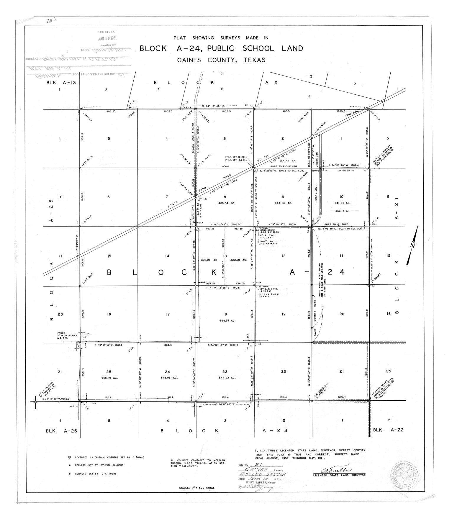
Gaines County Rolled Sketch 21
Plat showing surveys made in Block A-24, Public School Land, Gaines County, Texas
-
Map/Doc
5937
-
Collection
General Map Collection
-
Object Dates
6/10/1961 (File Date)
8/1957 - 5/1961 (Survey Date)
-
People and Organizations
C.A. Tubbs (Surveyor/Engineer)
-
Counties
Gaines
-
Subjects
Surveying Rolled Sketch
-
Height x Width
29.0 x 24.9 inches
73.7 x 63.3 cm
-
Scale
1" = 600 varas
Part of: General Map Collection
Hardeman County Working Sketch 18

Print $20.00
- Digital $50.00
Hardeman County Working Sketch 18
2002
Size 33.5 x 36.5 inches
Map/Doc 76401
Tarrant County Working Sketch 2

Print $20.00
- Digital $50.00
Tarrant County Working Sketch 2
1940
Size 21.3 x 19.5 inches
Map/Doc 62419
Wharton County Rolled Sketch 14

Print $20.00
- Digital $50.00
Wharton County Rolled Sketch 14
2020
Size 36.1 x 24.3 inches
Map/Doc 95915
Crockett County Working Sketch 50

Print $20.00
- Digital $50.00
Crockett County Working Sketch 50
1940
Size 30.3 x 24.9 inches
Map/Doc 68383
Cooke County Sketch File 45

Print $20.00
- Digital $50.00
Cooke County Sketch File 45
1849
Size 22.3 x 15.2 inches
Map/Doc 11179
Ward County State of Texas

Print $20.00
- Digital $50.00
Ward County State of Texas
1888
Size 22.6 x 26.0 inches
Map/Doc 4641
Gaines County Sketch File 5

Print $22.00
- Digital $50.00
Gaines County Sketch File 5
1915
Size 10.8 x 7.2 inches
Map/Doc 23177

Panola County Working Sketch 17

Print $40.00
- Digital $50.00
Panola County Working Sketch 17
1945
Map/Doc 71426
Shelby County Working Sketch 8

Print $20.00
- Digital $50.00
Shelby County Working Sketch 8
1942
Size 20.0 x 30.3 inches
Map/Doc 63861
Galveston Bay Entrance - Galveston and Texas City Harbors

Print $40.00
- Digital $50.00
Galveston Bay Entrance - Galveston and Texas City Harbors
1982
Size 37.0 x 53.3 inches
Map/Doc 69865
Aransas Migratory Waterfowl Refuge, San Antonio Loan & Trust Company Tracts, 45,596.98 acres, Aransas and Refugio Counties

Print $20.00
- Digital $50.00
Aransas Migratory Waterfowl Refuge, San Antonio Loan & Trust Company Tracts, 45,596.98 acres, Aransas and Refugio Counties
1937
Size 41.1 x 30.8 inches
Map/Doc 3073
You may also like
Fort Bend County Sketch File 8

Print $6.00
- Digital $50.00
Fort Bend County Sketch File 8
Size 6.3 x 4.2 inches
Map/Doc 22894
General Highway Map, Comanche County, Texas

Print $20.00
General Highway Map, Comanche County, Texas
1961
Size 24.7 x 18.2 inches
Map/Doc 79419
Texas Boundary Line

Print $20.00
- Digital $50.00
Texas Boundary Line
Size 21.6 x 11.9 inches
Map/Doc 92078
Kinney County Sketch File 34

Print $8.00
- Digital $50.00
Kinney County Sketch File 34
1941
Size 14.2 x 8.8 inches
Map/Doc 29181
Sterling County Working Sketch 11

Print $20.00
- Digital $50.00
Sterling County Working Sketch 11
1987
Size 20.1 x 40.8 inches
Map/Doc 63993
Intracoastal Waterway - Laguna Madre - Chubby Island to Stover Point including the Arroyo Colorado, Texas

Print $20.00
- Digital $50.00
Intracoastal Waterway - Laguna Madre - Chubby Island to Stover Point including the Arroyo Colorado, Texas
1976
Size 16.0 x 43.9 inches
Map/Doc 75901

Coryell County Working Sketch 7
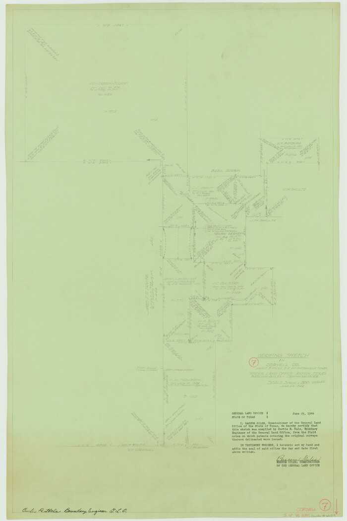
Print $20.00
- Digital $50.00
Coryell County Working Sketch 7
1944
Size 31.6 x 21.1 inches
Map/Doc 68214
Runnels County Working Sketch 3

Print $20.00
- Digital $50.00
Runnels County Working Sketch 3
1888
Size 22.1 x 20.3 inches
Map/Doc 63599
Coke County Boundary File 1

Print $50.00
- Digital $50.00
Coke County Boundary File 1
Size 8.9 x 4.0 inches
Map/Doc 51570
Galveston County Rolled Sketch 25

Print $20.00
- Digital $50.00
Galveston County Rolled Sketch 25
1965
Size 18.7 x 24.5 inches
Map/Doc 5959
Throckmorton County Working Sketch 5

Print $20.00
- Digital $50.00
Throckmorton County Working Sketch 5
1927
Size 31.8 x 24.4 inches
Map/Doc 62114