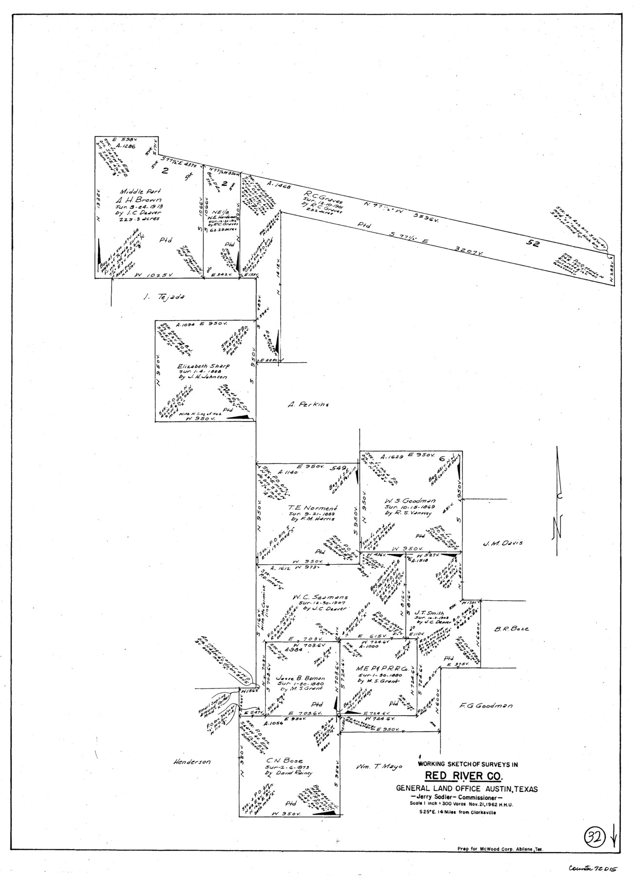
Red River County Working Sketch 32
-
Map/Doc
72015
-
Collection
General Map Collection
-
Object Dates
11/21/1962 (Creation Date)
-
People and Organizations
Herbert H. Ulbricht (Draftsman)
-
Counties
Red River
-
Subjects
Surveying Working Sketch
-
Height x Width
27.6 x 20.0 inches
70.1 x 50.8 cm
-
Scale
1" = 300 varas
Part of: General Map Collection
Zavala County Rolled Sketch 29

Print $40.00
- Digital $50.00
Zavala County Rolled Sketch 29
Size 50.9 x 45.1 inches
Map/Doc 10177
Flight Mission No. CRC-3R, Frame 201, Chambers County

Print $20.00
- Digital $50.00
Flight Mission No. CRC-3R, Frame 201, Chambers County
1956
Size 18.6 x 22.4 inches
Map/Doc 84856
University Land Field Notes for Blocks 39, 41, 42, 44, 45, 46, 47, 50, and 51 in Crockett County, Blocks 38 and 40 in Crockett and Irion Counties, and Blocks 48 and 49 in Crockett and Reagan Counties, and Block 43 in Crockett, Irion, and Reagan Counties

University Land Field Notes for Blocks 39, 41, 42, 44, 45, 46, 47, 50, and 51 in Crockett County, Blocks 38 and 40 in Crockett and Irion Counties, and Blocks 48 and 49 in Crockett and Reagan Counties, and Block 43 in Crockett, Irion, and Reagan Counties
Map/Doc 81718
Stonewall County Rolled Sketch 32

Print $20.00
- Digital $50.00
Stonewall County Rolled Sketch 32
1951
Size 19.4 x 33.6 inches
Map/Doc 7876
Sterling County Rolled Sketch 29

Print $20.00
- Digital $50.00
Sterling County Rolled Sketch 29
Size 30.0 x 23.5 inches
Map/Doc 7854
Sutton County Sketch File 27B

Print $20.00
- Digital $50.00
Sutton County Sketch File 27B
Size 19.1 x 14.6 inches
Map/Doc 12384
Roberts County Boundary File 2d

Print $20.00
- Digital $50.00
Roberts County Boundary File 2d
Size 9.1 x 28.1 inches
Map/Doc 58366
Boundary Between the United States & Mexico Agreed upon by the Joint Commission under the Treaty of Guadalupe Hidalgo

Print $20.00
- Digital $50.00
Boundary Between the United States & Mexico Agreed upon by the Joint Commission under the Treaty of Guadalupe Hidalgo
1853
Size 18.2 x 26.4 inches
Map/Doc 72883
Nueces County Rolled Sketch 29

Print $20.00
- Digital $50.00
Nueces County Rolled Sketch 29
1951
Size 25.0 x 22.7 inches
Map/Doc 6875
Webb County Sketch File 6-1

Print $6.00
- Digital $50.00
Webb County Sketch File 6-1
1877
Size 9.8 x 12.7 inches
Map/Doc 39737
Hopkins County

Print $20.00
- Digital $50.00
Hopkins County
1942
Size 43.6 x 41.6 inches
Map/Doc 1858
Nueces County Working Sketch 4

Print $20.00
- Digital $50.00
Nueces County Working Sketch 4
1951
Size 46.8 x 36.2 inches
Map/Doc 71306
You may also like
[Tie line between Indianola RR. Co. Block H and H. & G. N. RR. Co. Block G and vicinity]
![93007, [Tie line between Indianola RR. Co. Block H and H. & G. N. RR. Co. Block G and vicinity], Twichell Survey Records](https://historictexasmaps.com/wmedia_w700/maps/93007-1.tif.jpg)
Print $20.00
- Digital $50.00
[Tie line between Indianola RR. Co. Block H and H. & G. N. RR. Co. Block G and vicinity]
1904
Size 21.9 x 10.1 inches
Map/Doc 93007
Flight Mission No. CUG-3P, Frame 133, Kleberg County

Print $20.00
- Digital $50.00
Flight Mission No. CUG-3P, Frame 133, Kleberg County
1956
Size 18.7 x 22.2 inches
Map/Doc 86268
Nueces County Rolled Sketch 12

Print $40.00
- Digital $50.00
Nueces County Rolled Sketch 12
Size 40.3 x 54.1 inches
Map/Doc 9587
Runnels County Rolled Sketch 46

Print $20.00
- Digital $50.00
Runnels County Rolled Sketch 46
1954
Size 32.3 x 38.5 inches
Map/Doc 10622
[Sketch showing E. line of Lipscomb County along Oklahoma border]
![89718, [Sketch showing E. line of Lipscomb County along Oklahoma border], Twichell Survey Records](https://historictexasmaps.com/wmedia_w700/maps/89718-1.tif.jpg)
Print $40.00
- Digital $50.00
[Sketch showing E. line of Lipscomb County along Oklahoma border]
Size 68.7 x 9.6 inches
Map/Doc 89718
Kleberg County Working Sketch Graphic Index

Print $20.00
- Digital $50.00
Kleberg County Working Sketch Graphic Index
1913
Size 29.0 x 32.9 inches
Map/Doc 76610
General Highway Map, Atascosa County, Texas

Print $20.00
General Highway Map, Atascosa County, Texas
1961
Size 18.3 x 24.9 inches
Map/Doc 79356
Somervell County Sketch File 4

Print $4.00
- Digital $50.00
Somervell County Sketch File 4
Size 6.4 x 8.8 inches
Map/Doc 36800
General Highway Map, Hutchinson County, Texas

Print $20.00
General Highway Map, Hutchinson County, Texas
1961
Size 18.1 x 24.6 inches
Map/Doc 79529
Amistad International Reservoir on Rio Grande 72

Print $20.00
- Digital $50.00
Amistad International Reservoir on Rio Grande 72
1949
Size 28.4 x 39.6 inches
Map/Doc 73360
[Sketch N, showing Blocks C-10, C-14 through C-16]
![91772, [Sketch N, showing Blocks C-10, C-14 through C-16], Twichell Survey Records](https://historictexasmaps.com/wmedia_w700/maps/91772-1.tif.jpg)
Print $20.00
- Digital $50.00
[Sketch N, showing Blocks C-10, C-14 through C-16]
Size 38.6 x 22.1 inches
Map/Doc 91772
