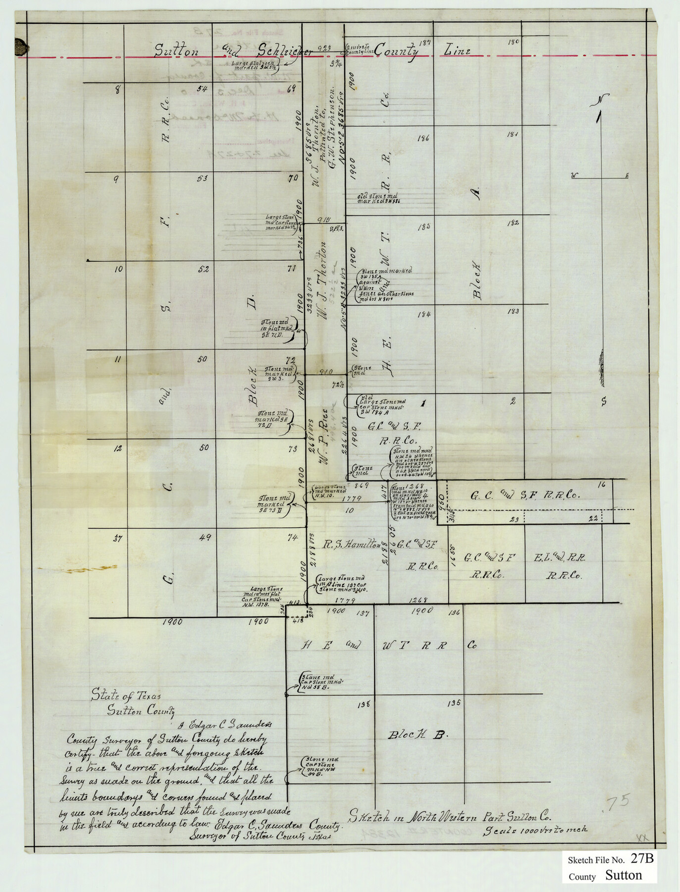
Sutton County Sketch File 27B
Sketch in North Western Part of Sutton County, Texas
-
Map/Doc
12384
-
Collection
General Map Collection
-
Counties
Sutton Schleicher
-
Subjects
Surveying Sketch File
-
Height x Width
19.1 x 14.6 inches
48.5 x 37.1 cm
-
Medium
paper, manuscript
-
Scale
1" = 1000 varas
Part of: General Map Collection
Live Oak County Boundary File 60

Print $12.00
- Digital $50.00
Live Oak County Boundary File 60
Size 8.8 x 7.6 inches
Map/Doc 56401
Flight Mission No. CUG-3P, Frame 191, Kleberg County

Print $20.00
- Digital $50.00
Flight Mission No. CUG-3P, Frame 191, Kleberg County
1956
Size 18.5 x 22.3 inches
Map/Doc 86295
Coryell County Rolled Sketch 3

Print $20.00
- Digital $50.00
Coryell County Rolled Sketch 3
1974
Size 24.6 x 36.4 inches
Map/Doc 5567
Flight Mission No. DAG-23K, Frame 167, Matagorda County

Print $20.00
- Digital $50.00
Flight Mission No. DAG-23K, Frame 167, Matagorda County
1953
Size 15.9 x 19.1 inches
Map/Doc 86505
Jack County Rolled Sketch 2

Print $20.00
- Digital $50.00
Jack County Rolled Sketch 2
1972
Size 31.3 x 29.0 inches
Map/Doc 6332
Castro County Working Sketch 9

Print $20.00
- Digital $50.00
Castro County Working Sketch 9
1965
Size 43.1 x 47.7 inches
Map/Doc 68646
Hale County Boundary File 7

Print $48.00
- Digital $50.00
Hale County Boundary File 7
Size 25.0 x 18.6 inches
Map/Doc 54075
Right of Way and Track Map, the Missouri, Kansas and Texas Ry. of Texas - Henrietta Division

Print $20.00
- Digital $50.00
Right of Way and Track Map, the Missouri, Kansas and Texas Ry. of Texas - Henrietta Division
1918
Size 11.8 x 26.9 inches
Map/Doc 64748
Coast Chart No. 211 - Padre I. and Laguna Madre, Lat. 27° 12' to Lat. 26° 33', Texas

Print $20.00
- Digital $50.00
Coast Chart No. 211 - Padre I. and Laguna Madre, Lat. 27° 12' to Lat. 26° 33', Texas
1890
Size 40.1 x 33.7 inches
Map/Doc 73500
Kleberg County Rolled Sketch 13

Print $20.00
- Digital $50.00
Kleberg County Rolled Sketch 13
1995
Size 39.3 x 33.8 inches
Map/Doc 6554
Gregg County Rolled Sketch RG

Print $20.00
- Digital $50.00
Gregg County Rolled Sketch RG
Size 44.4 x 36.0 inches
Map/Doc 9025
Fannin County Rolled Sketch 18E

Print $2.00
- Digital $50.00
Fannin County Rolled Sketch 18E
Size 9.5 x 8.2 inches
Map/Doc 5872
You may also like
Texas Gulf Coast Map from the Sabine River to the Rio Grande as subdivided for mineral development

Print $40.00
- Digital $50.00
Texas Gulf Coast Map from the Sabine River to the Rio Grande as subdivided for mineral development
1948
Size 49.3 x 55.7 inches
Map/Doc 2906
Map of Randall County

Print $20.00
- Digital $50.00
Map of Randall County
1892
Size 24.4 x 18.6 inches
Map/Doc 3975
Smith County Rolled Sketch 6A1

Print $40.00
- Digital $50.00
Smith County Rolled Sketch 6A1
Size 49.2 x 38.6 inches
Map/Doc 10704
Atlas E, Sketch 29 (E-29)

Print $20.00
- Digital $50.00
Atlas E, Sketch 29 (E-29)
Size 22.4 x 33.2 inches
Map/Doc 78363
Flight Mission No. CRE-1R, Frame 191, Jackson County

Print $20.00
- Digital $50.00
Flight Mission No. CRE-1R, Frame 191, Jackson County
1956
Size 18.4 x 22.3 inches
Map/Doc 85345
Jeff Davis County Working Sketch 21

Print $20.00
- Digital $50.00
Jeff Davis County Working Sketch 21
1957
Size 25.2 x 44.0 inches
Map/Doc 66516
Sketch for Blocks D6, D7, D8 situated in Val Verde County, Texas

Print $40.00
- Digital $50.00
Sketch for Blocks D6, D7, D8 situated in Val Verde County, Texas
1937
Size 100.1 x 40.0 inches
Map/Doc 93166
Map of Webb County

Print $20.00
- Digital $50.00
Map of Webb County
1895
Size 34.8 x 27.0 inches
Map/Doc 4132

J. W. Kendrick Land, Crosby County, Texas

Print $20.00
- Digital $50.00
J. W. Kendrick Land, Crosby County, Texas
Size 43.1 x 33.8 inches
Map/Doc 92604
Orange County Working Sketch 14

Print $40.00
- Digital $50.00
Orange County Working Sketch 14
1923
Size 28.4 x 56.1 inches
Map/Doc 71346
Map of Texas and the Countries Adjacent compiled in the Bureau of the Corps of Topographical Engineers from the Best Authorities

Print $20.00
- Digital $50.00
Map of Texas and the Countries Adjacent compiled in the Bureau of the Corps of Topographical Engineers from the Best Authorities
1844
Size 22.3 x 33.4 inches
Map/Doc 93867