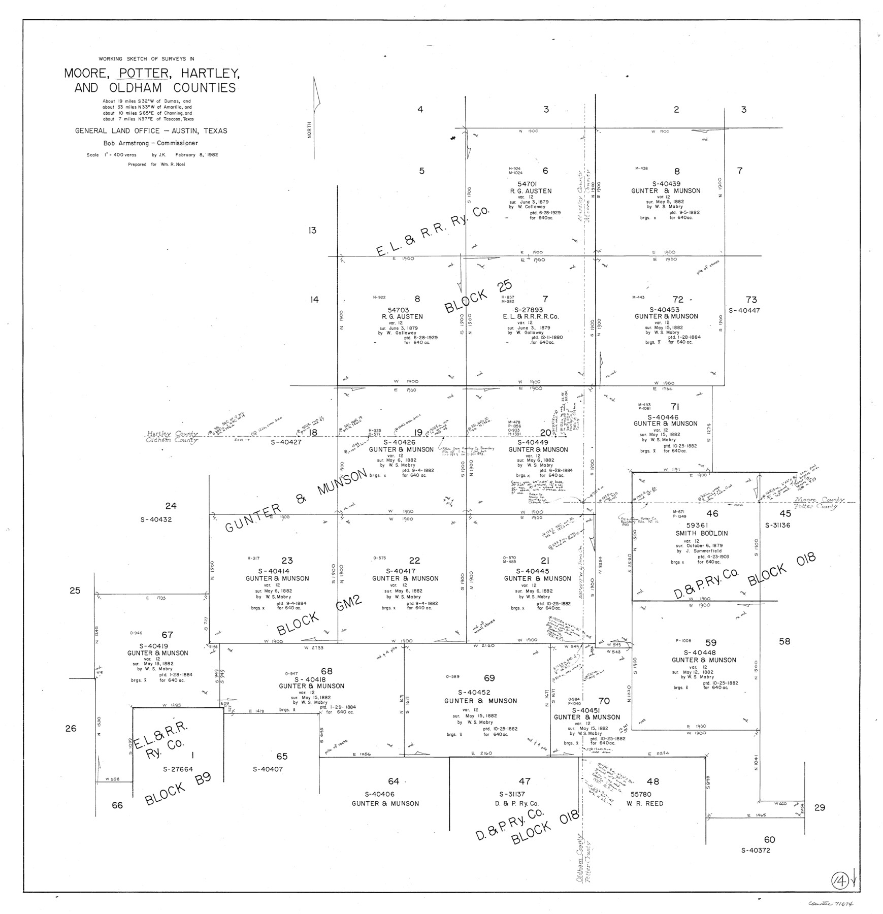
Potter County Working Sketch 14
-
Map/Doc
71674
-
Collection
General Map Collection
-
Object Dates
2/8/1982 (Creation Date)
-
People and Organizations
Joan Kilpatrick (Draftsman)
-
Counties
Potter Moore Hartley Oldham
-
Subjects
Surveying Working Sketch
-
Height x Width
33.7 x 32.6 inches
85.6 x 82.8 cm
-
Scale
1" = 400 varas
Part of: General Map Collection
Flight Mission No. CRE-1R, Frame 65, Jackson County

Print $20.00
- Digital $50.00
Flight Mission No. CRE-1R, Frame 65, Jackson County
1956
Size 18.6 x 22.3 inches
Map/Doc 85328
Wilbarger County Sketch File 17

Print $4.00
- Digital $50.00
Wilbarger County Sketch File 17
1886
Size 14.2 x 8.7 inches
Map/Doc 40207
Nueces County Rolled Sketch 44

Print $40.00
- Digital $50.00
Nueces County Rolled Sketch 44
1948
Size 40.0 x 60.8 inches
Map/Doc 9602
Frio County Working Sketch 18

Print $20.00
- Digital $50.00
Frio County Working Sketch 18
1982
Size 35.7 x 36.8 inches
Map/Doc 69292
Uvalde County Working Sketch 21

Print $20.00
- Digital $50.00
Uvalde County Working Sketch 21
1949
Size 21.2 x 18.2 inches
Map/Doc 72091
Hamilton County Rolled Sketch 14

Print $20.00
- Digital $50.00
Hamilton County Rolled Sketch 14
1989
Size 28.0 x 40.0 inches
Map/Doc 6063
Coke County Working Sketch Graphic Index

Print $20.00
- Digital $50.00
Coke County Working Sketch Graphic Index
1945
Size 38.9 x 41.5 inches
Map/Doc 76496
Crosby County Rolled Sketch R

Print $20.00
- Digital $50.00
Crosby County Rolled Sketch R
1926
Size 41.2 x 40.0 inches
Map/Doc 8740

Kenedy County

Print $20.00
- Digital $50.00
Kenedy County
1913
Size 41.0 x 31.8 inches
Map/Doc 66888
Polk County Sketch File 29 1/2

Print $4.00
- Digital $50.00
Polk County Sketch File 29 1/2
Size 8.7 x 12.5 inches
Map/Doc 34204
Nacogdoches County Sketch File 21

Print $20.00
- Digital $50.00
Nacogdoches County Sketch File 21
1837
Size 9.4 x 5.5 inches
Map/Doc 32286
You may also like
Nueces County Sketch File 32

Print $32.00
- Digital $50.00
Nueces County Sketch File 32
1907
Size 14.2 x 8.7 inches
Map/Doc 32605
Gray County Sketch File 5

Print $16.00
- Digital $50.00
Gray County Sketch File 5
1882
Size 12.8 x 8.3 inches
Map/Doc 24418
Flight Mission No. DAG-21K, Frame 122, Matagorda County

Print $20.00
- Digital $50.00
Flight Mission No. DAG-21K, Frame 122, Matagorda County
1952
Size 18.6 x 22.4 inches
Map/Doc 86448
[Pencil sketch around J. Walters, J. G. Welchmeyer, R. Gage surveys]
![90206, [Pencil sketch around J. Walters, J. G. Welchmeyer, R. Gage surveys], Twichell Survey Records](https://historictexasmaps.com/wmedia_w700/maps/90206-1.tif.jpg)
Print $20.00
- Digital $50.00
[Pencil sketch around J. Walters, J. G. Welchmeyer, R. Gage surveys]
Size 25.5 x 21.7 inches
Map/Doc 90206
Karnes County Sketch File 10

Print $10.00
- Digital $50.00
Karnes County Sketch File 10
1885
Size 12.8 x 8.5 inches
Map/Doc 28597
Flight Mission No. DIX-5P, Frame 104, Aransas County

Print $20.00
- Digital $50.00
Flight Mission No. DIX-5P, Frame 104, Aransas County
1956
Size 17.8 x 18.5 inches
Map/Doc 83782
Nautical Chart 892-SC - Intracoastal Waterway - Carlos Bay to Redfish Bay including Copano Bay, Texas

Print $40.00
- Digital $50.00
Nautical Chart 892-SC - Intracoastal Waterway - Carlos Bay to Redfish Bay including Copano Bay, Texas
1972
Size 16.8 x 51.8 inches
Map/Doc 73440
Louisiana and Texas Intracoastal Waterway - Entrance near Port O'Connor, Texas, Survey of September, 1940

Print $20.00
- Digital $50.00
Louisiana and Texas Intracoastal Waterway - Entrance near Port O'Connor, Texas, Survey of September, 1940
1940
Size 31.2 x 41.5 inches
Map/Doc 61822
Flight Mission No. DQN-3K, Frame 50, Calhoun County

Print $20.00
- Digital $50.00
Flight Mission No. DQN-3K, Frame 50, Calhoun County
1953
Size 18.4 x 22.2 inches
Map/Doc 84351
Upshur County Sketch File 2

Print $4.00
- Digital $50.00
Upshur County Sketch File 2
1848
Size 8.5 x 11.0 inches
Map/Doc 38732
1875 land survey for the International and Great Northern Rail-road Company

Print $40.00
- Digital $50.00
1875 land survey for the International and Great Northern Rail-road Company
1875
Size 42.5 x 60.6 inches
Map/Doc 2306
Presidio County Rolled Sketch 40

Print $20.00
- Digital $50.00
Presidio County Rolled Sketch 40
1907
Size 16.5 x 21.5 inches
Map/Doc 7337