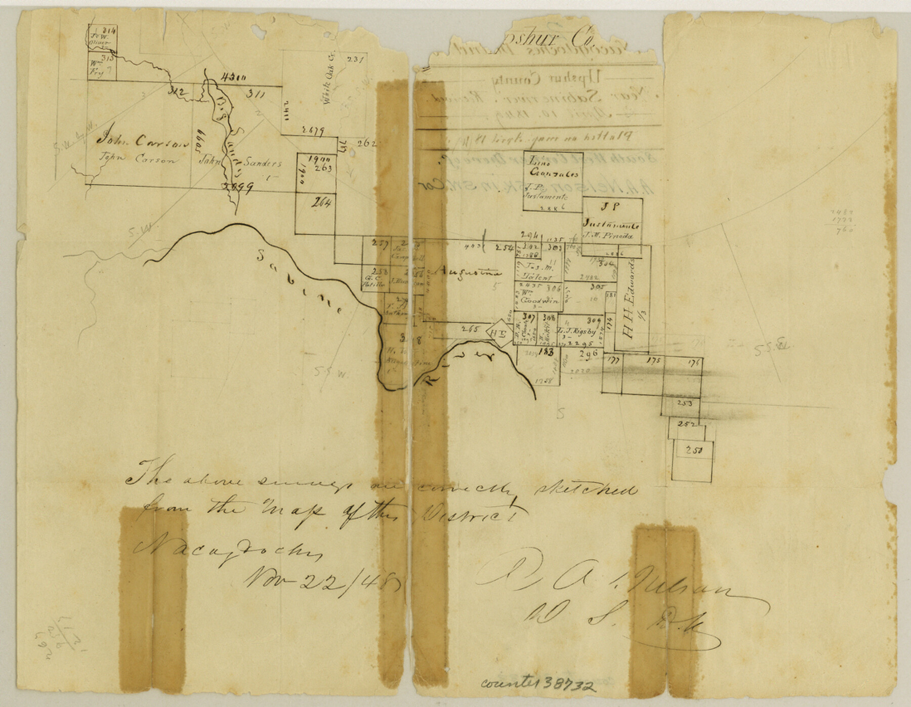
Upshur County Sketch File 2
[Sketch of surveys in the south part of the county]
-
Map/Doc
38732
-
Collection
General Map Collection
-
Object Dates
11/22/1848 (Creation Date)
4/10/1849 (File Date)
-
People and Organizations
A.A. Nelson (Surveyor/Engineer)
-
Counties
Upshur Gregg
-
Subjects
Surveying Sketch File
-
Height x Width
8.5 x 11.0 inches
21.6 x 27.9 cm
-
Medium
paper, manuscript
-
Features
Big Sandy Creek
Sabine Riiver
Part of: General Map Collection
Shelby County Rolled Sketch 7

Print $40.00
- Digital $50.00
Shelby County Rolled Sketch 7
1945
Size 61.1 x 44.4 inches
Map/Doc 9922
Childress County Rolled Sketch 9D

Print $3.00
- Digital $50.00
Childress County Rolled Sketch 9D
1945
Size 16.0 x 10.0 inches
Map/Doc 78221
Crockett County Rolled Sketch 74

Print $20.00
- Digital $50.00
Crockett County Rolled Sketch 74
1949
Size 19.4 x 24.9 inches
Map/Doc 5615
Map of the Mexican National R.R. "Laredo Route" and Connections. The Scenic Short Line to the City of Mexico

Print $20.00
- Digital $50.00
Map of the Mexican National R.R. "Laredo Route" and Connections. The Scenic Short Line to the City of Mexico
1901
Size 24.2 x 24.3 inches
Map/Doc 95145
Montague County

Print $20.00
- Digital $50.00
Montague County
1924
Size 47.0 x 34.2 inches
Map/Doc 66938
Bowie County Working Sketch 17

Print $20.00
- Digital $50.00
Bowie County Working Sketch 17
1962
Size 24.5 x 20.0 inches
Map/Doc 67421
Flight Mission No. DAG-24K, Frame 156, Matagorda County

Print $20.00
- Digital $50.00
Flight Mission No. DAG-24K, Frame 156, Matagorda County
1953
Size 18.4 x 22.3 inches
Map/Doc 86570
1988 Land Use - El Paso, Ciudad Juarez and Vicinity

Print $20.00
- Digital $50.00
1988 Land Use - El Paso, Ciudad Juarez and Vicinity
1988
Size 34.1 x 25.0 inches
Map/Doc 87370
Fort Bend County Rolled Sketch 6

Print $20.00
- Digital $50.00
Fort Bend County Rolled Sketch 6
1967
Size 26.1 x 35.4 inches
Map/Doc 5897
Index Map No. 1 - Rio Bravo del Norte section of boundary between the United States & Mexico; agreed upon by the Joint Commission under the Treaty of Guadalupe Hidalgo

Print $20.00
- Digital $50.00
Index Map No. 1 - Rio Bravo del Norte section of boundary between the United States & Mexico; agreed upon by the Joint Commission under the Treaty of Guadalupe Hidalgo
1852
Size 18.3 x 27.5 inches
Map/Doc 72862
Jefferson County Rolled Sketch 60

Print $40.00
- Digital $50.00
Jefferson County Rolled Sketch 60
Size 56.1 x 34.7 inches
Map/Doc 9317
Clay County Sketch File 42

Print $20.00
- Digital $50.00
Clay County Sketch File 42
Size 22.8 x 31.0 inches
Map/Doc 11093
You may also like
Ward County Working Sketch 34

Print $20.00
- Digital $50.00
Ward County Working Sketch 34
1968
Size 26.7 x 30.5 inches
Map/Doc 72340
Flight Mission No. DQN-6K, Frame 90, Calhoun County

Print $20.00
- Digital $50.00
Flight Mission No. DQN-6K, Frame 90, Calhoun County
1953
Size 18.6 x 22.2 inches
Map/Doc 84450
Cass County Working Sketch 40

Print $20.00
- Digital $50.00
Cass County Working Sketch 40
1984
Size 24.6 x 24.5 inches
Map/Doc 67943
Map of the State of Texas showing the Line and Lands of the Texas and Pacific Railway Reserved and Donated by the State of Texas

Print $20.00
Map of the State of Texas showing the Line and Lands of the Texas and Pacific Railway Reserved and Donated by the State of Texas
1873
Size 20.2 x 25.1 inches
Map/Doc 76317
Hemphill County Rolled Sketch 7

Print $20.00
- Digital $50.00
Hemphill County Rolled Sketch 7
1902
Size 21.8 x 25.4 inches
Map/Doc 6189
Erath County Sketch File 14

Print $4.00
- Digital $50.00
Erath County Sketch File 14
1872
Size 13.0 x 8.5 inches
Map/Doc 22290
Fisher County Sketch File 11

Print $20.00
- Digital $50.00
Fisher County Sketch File 11
Size 22.8 x 20.4 inches
Map/Doc 11478

[Area south of Runnels County School Land]
![93168, [Area south of Runnels County School Land], Twichell Survey Records](https://historictexasmaps.com/wmedia_w700/maps/93168-1.tif.jpg)
Print $40.00
- Digital $50.00
[Area south of Runnels County School Land]
Size 87.7 x 42.9 inches
Map/Doc 93168
The Republic County of Liberty. Spring 1842

Print $20.00
The Republic County of Liberty. Spring 1842
2020
Size 19.9 x 21.7 inches
Map/Doc 96212

Hudspeth County Rolled Sketch 41

Print $40.00
- Digital $50.00
Hudspeth County Rolled Sketch 41
1947
Size 12.6 x 83.1 inches
Map/Doc 76043