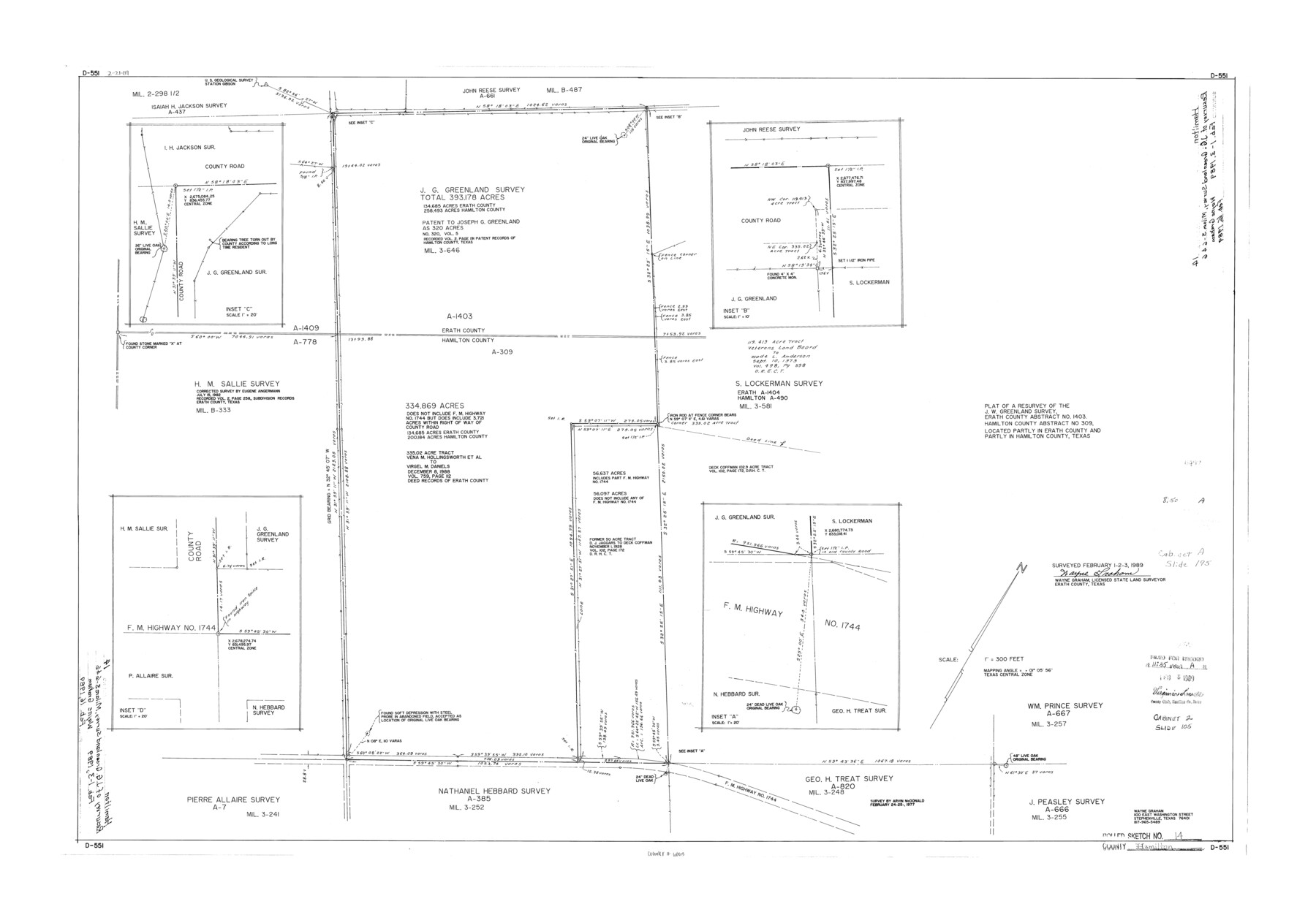
Hamilton County Rolled Sketch 14
Plat of a resurvey of the J.W. Greenland survey, Erath County abstract no. 1403, Hamilton County abstract no. 309, located partly in Erath County and partly in Hamilton County, Texas
-
Map/Doc
6063
-
Collection
General Map Collection
-
Object Dates
1989/2/3 (Creation Date)
1989/2/16 (File Date)
-
People and Organizations
Wayne Graham (Surveyor/Engineer)
-
Counties
Hamilton Erath
-
Subjects
Surveying Rolled Sketch
-
Height x Width
28.0 x 40.0 inches
71.1 x 101.6 cm
-
Medium
mylar, print
-
Scale
1" = 300 feet
Part of: General Map Collection
Orange County Sketch File 4

Print $34.00
- Digital $50.00
Orange County Sketch File 4
1852
Size 8.2 x 7.7 inches
Map/Doc 33301
[Fort Worth & Rio Grande Ry.]
![64354, [Fort Worth & Rio Grande Ry.], General Map Collection](https://historictexasmaps.com/wmedia_w700/maps/64354.tif.jpg)
Print $20.00
- Digital $50.00
[Fort Worth & Rio Grande Ry.]
Size 15.2 x 43.0 inches
Map/Doc 64354
Reeves County Working Sketch 51

Print $20.00
- Digital $50.00
Reeves County Working Sketch 51
1974
Size 45.4 x 34.6 inches
Map/Doc 63494
[F. W. & D. C. Ry. Co. Alignment and Right of Way Map, Clay County]
![64728, [F. W. & D. C. Ry. Co. Alignment and Right of Way Map, Clay County], General Map Collection](https://historictexasmaps.com/wmedia_w700/maps/64728-1.tif.jpg)
Print $20.00
- Digital $50.00
[F. W. & D. C. Ry. Co. Alignment and Right of Way Map, Clay County]
1927
Size 18.8 x 11.7 inches
Map/Doc 64728

Mason County Working Sketch 21

Print $20.00
- Digital $50.00
Mason County Working Sketch 21
1945
Size 37.1 x 43.2 inches
Map/Doc 70857
Harris County Rolled Sketch AA3

Print $20.00
- Digital $50.00
Harris County Rolled Sketch AA3
Size 30.8 x 25.9 inches
Map/Doc 6139
Maps of Gulf Intracoastal Waterway, Texas - Sabine River to the Rio Grande and connecting waterways including ship channels

Print $20.00
- Digital $50.00
Maps of Gulf Intracoastal Waterway, Texas - Sabine River to the Rio Grande and connecting waterways including ship channels
1966
Size 14.6 x 22.2 inches
Map/Doc 61967
National Map Company's Map of Texas showing counties, cities, towns, villages and post offices, steam and electric railways with stations and distance between stations

Print $40.00
- Digital $50.00
National Map Company's Map of Texas showing counties, cities, towns, villages and post offices, steam and electric railways with stations and distance between stations
1920
Size 50.3 x 51.1 inches
Map/Doc 10749
Kaufman County

Print $40.00
- Digital $50.00
Kaufman County
1942
Size 50.0 x 41.0 inches
Map/Doc 95552
Goliad County Working Sketch 23

Print $20.00
- Digital $50.00
Goliad County Working Sketch 23
1979
Size 26.8 x 32.9 inches
Map/Doc 63213
Map of Dickens County

Print $20.00
- Digital $50.00
Map of Dickens County
1899
Size 40.7 x 36.7 inches
Map/Doc 16822
You may also like
Pecos County Rolled Sketch 105

Print $20.00
- Digital $50.00
Pecos County Rolled Sketch 105
1940
Size 30.7 x 37.7 inches
Map/Doc 9717
Burleson County Working Sketch 32

Print $20.00
- Digital $50.00
Burleson County Working Sketch 32
1981
Size 26.3 x 13.5 inches
Map/Doc 67751
Hansford County

Print $20.00
- Digital $50.00
Hansford County
1889
Size 22.9 x 18.5 inches
Map/Doc 3624
Outer Continental Shelf Leasing Maps (Texas Offshore Operations)

Print $20.00
- Digital $50.00
Outer Continental Shelf Leasing Maps (Texas Offshore Operations)
Size 17.6 x 13.6 inches
Map/Doc 75850
[Block K5, Section 13]
![91452, [Block K5, Section 13], Twichell Survey Records](https://historictexasmaps.com/wmedia_w700/maps/91452-1.tif.jpg)
Print $20.00
- Digital $50.00
[Block K5, Section 13]
Size 22.2 x 18.5 inches
Map/Doc 91452
Flight Mission No. CRC-3R, Frame 34, Chambers County

Print $20.00
- Digital $50.00
Flight Mission No. CRC-3R, Frame 34, Chambers County
1956
Size 18.5 x 22.3 inches
Map/Doc 84807
Colorado County Working Sketch 9

Print $20.00
- Digital $50.00
Colorado County Working Sketch 9
1939
Size 12.0 x 15.7 inches
Map/Doc 68109
Flight Mission No. BRA-8M, Frame 147, Jefferson County

Print $20.00
- Digital $50.00
Flight Mission No. BRA-8M, Frame 147, Jefferson County
1953
Size 16.0 x 15.9 inches
Map/Doc 85639
[McK. & Williams No. 601 and surrounding surveys, Travis County]
![75553, [McK. & Williams No. 601 and surrounding surveys, Travis County], Maddox Collection](https://historictexasmaps.com/wmedia_w700/maps/75553.tif.jpg)
Print $3.00
- Digital $50.00
[McK. & Williams No. 601 and surrounding surveys, Travis County]
Size 16.3 x 10.7 inches
Map/Doc 75553
Aransas Migratory Waterfowl Refuge, San Antonio Loan & Trust Company Tracts, 45,596.98 acres, Aransas and Refugio Counties

Print $20.00
- Digital $50.00
Aransas Migratory Waterfowl Refuge, San Antonio Loan & Trust Company Tracts, 45,596.98 acres, Aransas and Refugio Counties
1937
Size 41.1 x 30.8 inches
Map/Doc 3073
Shelby County

Print $20.00
- Digital $50.00
Shelby County
1945
Size 41.5 x 46.1 inches
Map/Doc 63034
Brazoria County Working Sketch 7

Print $20.00
- Digital $50.00
Brazoria County Working Sketch 7
1930
Size 40.9 x 21.1 inches
Map/Doc 67492