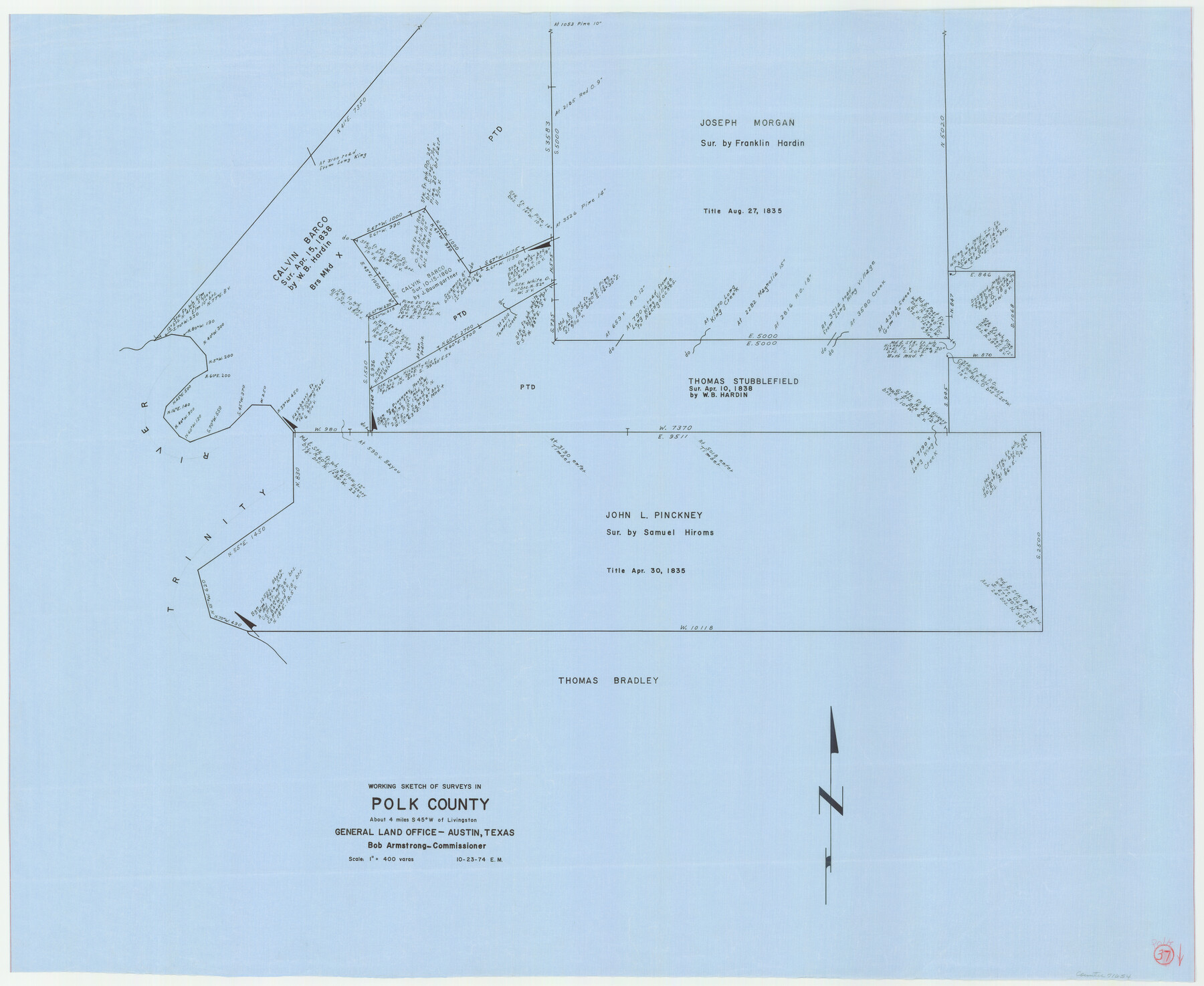
Polk County Working Sketch 37
-
Map/Doc
71654
-
Collection
General Map Collection
-
Object Dates
10/23/1974 (Creation Date)
-
People and Organizations
Elbert Menzel (Draftsman)
-
Counties
Polk
-
Subjects
Surveying Working Sketch
-
Height x Width
31.3 x 38.2 inches
79.5 x 97.0 cm
-
Scale
1" = 400 varas
Part of: General Map Collection
Harris County Historic Topographic 27

Print $20.00
- Digital $50.00
Harris County Historic Topographic 27
1915
Size 19.8 x 23.5 inches
Map/Doc 65838
Webb County Sketch File 66

Print $20.00
- Digital $50.00
Webb County Sketch File 66
1950
Size 13.4 x 20.6 inches
Map/Doc 12655
Galveston County Working Sketch 23

Print $20.00
- Digital $50.00
Galveston County Working Sketch 23
1988
Size 35.8 x 30.6 inches
Map/Doc 69360
Crockett County Sketch File 57

Print $22.00
- Digital $50.00
Crockett County Sketch File 57
Size 12.2 x 8.9 inches
Map/Doc 19832
[Sketch for Mineral Application 24072, San Jacinto River]
![65605, [Sketch for Mineral Application 24072, San Jacinto River], General Map Collection](https://historictexasmaps.com/wmedia_w700/maps/65605.tif.jpg)
Print $20.00
- Digital $50.00
[Sketch for Mineral Application 24072, San Jacinto River]
1929
Size 23.4 x 17.8 inches
Map/Doc 65605

Duval County Sketch File 42

Print $4.00
- Digital $50.00
Duval County Sketch File 42
1936
Size 14.4 x 8.8 inches
Map/Doc 21394
Gaines County Working Sketch 28

Print $20.00
- Digital $50.00
Gaines County Working Sketch 28
1982
Size 20.9 x 24.6 inches
Map/Doc 69328
1910 Map of the City of Houston and vicinity

Print $20.00
- Digital $50.00
1910 Map of the City of Houston and vicinity
1910
Size 20.5 x 23.4 inches
Map/Doc 97452
Comanche County Sketch File 14

Print $4.00
- Digital $50.00
Comanche County Sketch File 14
1859
Size 8.4 x 12.9 inches
Map/Doc 19078
Donley County Sketch File 2

Print $20.00
- Digital $50.00
Donley County Sketch File 2
Size 20.3 x 18.4 inches
Map/Doc 11363
Bell County Sketch File 8

Print $4.00
- Digital $50.00
Bell County Sketch File 8
1852
Size 14.2 x 8.9 inches
Map/Doc 14377
You may also like
Hardin County Sketch File 41 and 42

Print $8.00
- Digital $50.00
Hardin County Sketch File 41 and 42
Size 8.8 x 7.9 inches
Map/Doc 25188
Interior de Mexico

Print $20.00
- Digital $50.00
Interior de Mexico
1836
Size 13.5 x 18.0 inches
Map/Doc 97350
[West half of county, south of John H. Stephens Block S2]
![90976, [West half of county, south of John H. Stephens Block S2], Twichell Survey Records](https://historictexasmaps.com/wmedia_w700/maps/90976-1.tif.jpg)
Print $2.00
- Digital $50.00
[West half of county, south of John H. Stephens Block S2]
Size 11.8 x 8.7 inches
Map/Doc 90976
Flight Mission No. CRC-4R, Frame 76, Chambers County

Print $20.00
- Digital $50.00
Flight Mission No. CRC-4R, Frame 76, Chambers County
1956
Size 18.8 x 22.4 inches
Map/Doc 84880
Liberty County Working Sketch 64

Print $20.00
- Digital $50.00
Liberty County Working Sketch 64
1970
Size 21.3 x 26.8 inches
Map/Doc 70524
Starr County Sketch File 1

Print $4.00
- Digital $50.00
Starr County Sketch File 1
Size 10.3 x 5.1 inches
Map/Doc 36854
[Sections 61-65, I. & G. N. Block 1 and part of Block 194]
![91678, [Sections 61-65, I. & G. N. Block 1 and part of Block 194], Twichell Survey Records](https://historictexasmaps.com/wmedia_w700/maps/91678-1.tif.jpg)
Print $20.00
- Digital $50.00
[Sections 61-65, I. & G. N. Block 1 and part of Block 194]
Size 24.9 x 17.3 inches
Map/Doc 91678
Travis County Working Sketch 42

Print $20.00
- Digital $50.00
Travis County Working Sketch 42
1974
Size 32.5 x 35.2 inches
Map/Doc 69426
Winkler County Sketch File 4

Print $8.00
- Digital $50.00
Winkler County Sketch File 4
Size 14.3 x 8.8 inches
Map/Doc 40463
Shelby County Sketch File 9

Print $4.00
- Digital $50.00
Shelby County Sketch File 9
1858
Size 9.4 x 8.2 inches
Map/Doc 36609
Aransas County Working Sketch Graphic Index

Print $20.00
- Digital $50.00
Aransas County Working Sketch Graphic Index
1947
Size 36.8 x 36.6 inches
Map/Doc 76455
Flight Mission No. CGI-4N, Frame 158, Cameron County

Print $20.00
- Digital $50.00
Flight Mission No. CGI-4N, Frame 158, Cameron County
1955
Size 18.5 x 22.2 inches
Map/Doc 84666