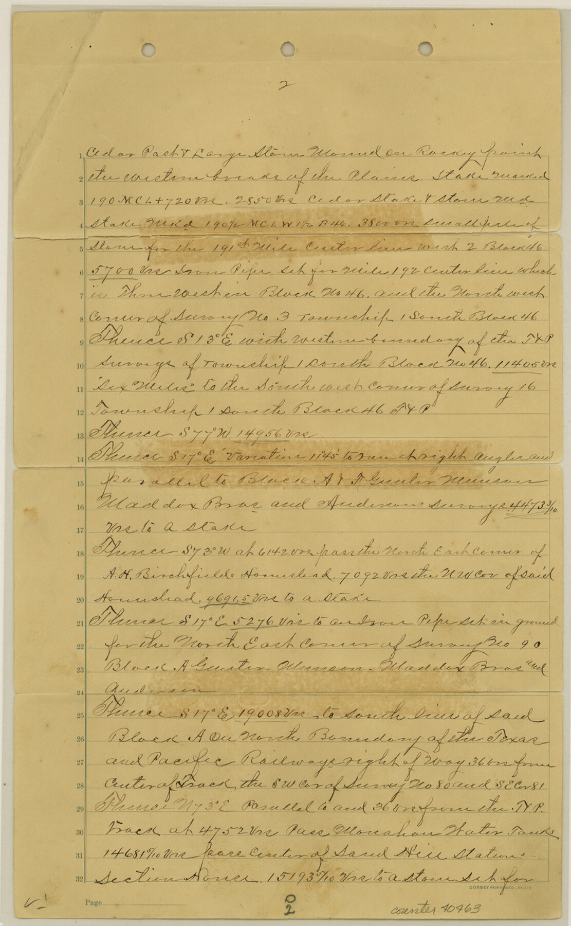
Winkler County Sketch File 4
[Field notes of a survey from southeast corner of New Mexico to the T. & P. RR. Co. surveys to the east]
-
Map/Doc
40463
-
Collection
General Map Collection
-
Object Dates
1899/9/5 (File Date)
1899/8/28 (Survey Date)
1899/9/5 (File Date)
-
People and Organizations
D.S. Woods (Surveyor/Engineer)
-
Counties
Winkler
-
Subjects
Surveying Sketch File
-
Height x Width
14.3 x 8.8 inches
36.3 x 22.4 cm
-
Medium
paper, manuscript
-
Features
Western Break of the Plains
Part of: General Map Collection
Anderson County Working Sketch Graphic Index

Print $40.00
- Digital $50.00
Anderson County Working Sketch Graphic Index
1942
Size 52.0 x 48.3 inches
Map/Doc 76452
Brewster County Rolled Sketch 47

Print $20.00
- Digital $50.00
Brewster County Rolled Sketch 47
1930
Size 18.1 x 41.0 inches
Map/Doc 5223
Williamson County Sketch File 17

Print $8.00
- Digital $50.00
Williamson County Sketch File 17
1876
Size 6.5 x 8.1 inches
Map/Doc 40338
Lampasas County Boundary File Index

Print $2.00
- Digital $50.00
Lampasas County Boundary File Index
Size 9.0 x 9.6 inches
Map/Doc 56092
Flight Mission No. DQN-1K, Frame 136, Calhoun County

Print $20.00
- Digital $50.00
Flight Mission No. DQN-1K, Frame 136, Calhoun County
1953
Size 18.5 x 22.3 inches
Map/Doc 84199
Jones County Sketch File 18

Print $6.00
- Digital $50.00
Jones County Sketch File 18
1981
Size 13.9 x 11.0 inches
Map/Doc 28514
County of Galveston, Texas

Print $20.00
- Digital $50.00
County of Galveston, Texas
1845
Size 22.9 x 32.2 inches
Map/Doc 3574
[St. L. S-W. Ry. of Texas Map of Lufkin Branch in Cherokee County Texas]
![64018, [St. L. S-W. Ry. of Texas Map of Lufkin Branch in Cherokee County Texas], General Map Collection](https://historictexasmaps.com/wmedia_w700/maps/64018.tif.jpg)
Print $40.00
- Digital $50.00
[St. L. S-W. Ry. of Texas Map of Lufkin Branch in Cherokee County Texas]
1912
Size 22.3 x 121.1 inches
Map/Doc 64018
Dickens County Working Sketch 4

Print $20.00
- Digital $50.00
Dickens County Working Sketch 4
1914
Size 27.9 x 18.8 inches
Map/Doc 68651
Aransas Pass to Baffin Bay

Print $20.00
- Digital $50.00
Aransas Pass to Baffin Bay
1922
Size 18.5 x 27.2 inches
Map/Doc 73408
Comanche County Sketch File 26

Print $20.00
- Digital $50.00
Comanche County Sketch File 26
Size 18.0 x 17.5 inches
Map/Doc 11144
Galveston Bay and Approaches

Print $20.00
- Digital $50.00
Galveston Bay and Approaches
1933
Size 46.0 x 34.9 inches
Map/Doc 69874
You may also like
Pecos County Working Sketch 11

Print $40.00
- Digital $50.00
Pecos County Working Sketch 11
1907
Size 48.6 x 38.2 inches
Map/Doc 71481
Culberson County Sketch File 39

Print $12.00
- Digital $50.00
Culberson County Sketch File 39
1968
Size 11.2 x 8.7 inches
Map/Doc 20306
Travis County Sketch File 20

Print $4.00
- Digital $50.00
Travis County Sketch File 20
Size 11.0 x 8.8 inches
Map/Doc 38323
Fractional Township No. 6 South Range No. 7 West of the Indian Meridian, Indian Territory

Print $20.00
- Digital $50.00
Fractional Township No. 6 South Range No. 7 West of the Indian Meridian, Indian Territory
1898
Size 19.4 x 24.3 inches
Map/Doc 75157
Glasscock County Sketch File 11

Print $6.00
- Digital $50.00
Glasscock County Sketch File 11
1933
Size 15.7 x 11.4 inches
Map/Doc 24174
Delta County Working Sketch 3

Print $20.00
- Digital $50.00
Delta County Working Sketch 3
1963
Size 24.9 x 24.4 inches
Map/Doc 68640
Real County Sketch File 3

Print $16.00
- Digital $50.00
Real County Sketch File 3
1906
Size 9.2 x 8.2 inches
Map/Doc 35039
![90573, [Block 3], Twichell Survey Records](https://historictexasmaps.com/wmedia_w700/maps/90573-1.tif.jpg)
South Sulphur River, Charleston Sheet

Print $4.00
- Digital $50.00
South Sulphur River, Charleston Sheet
1924
Size 29.4 x 29.5 inches
Map/Doc 65168
Wichita County Boundary File 5

Print $20.00
- Digital $50.00
Wichita County Boundary File 5
Size 11.0 x 38.5 inches
Map/Doc 59915
Burleson County Working Sketch 34

Print $20.00
- Digital $50.00
Burleson County Working Sketch 34
1981
Size 20.0 x 12.2 inches
Map/Doc 67753
Cass County Working Sketch 23

Print $40.00
- Digital $50.00
Cass County Working Sketch 23
1966
Size 56.8 x 37.1 inches
Map/Doc 67926