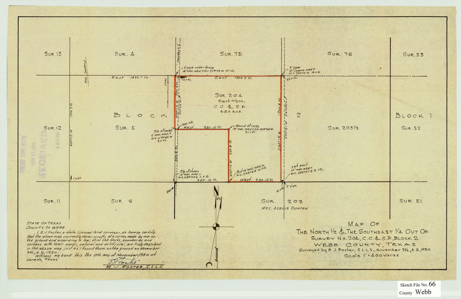
Webb County Sketch File 66
Map of the north 1/2 & the southeast 1/4 out of survey no. 204, C. C. & S. D., Block 2
-
Map/Doc
12655
-
Collection
General Map Collection
-
Object Dates
11/9/1950 (Creation Date)
11/20/1950 (File Date)
-
People and Organizations
E.J. Foster (Surveyor/Engineer)
-
Counties
Webb
-
Subjects
Surveying Sketch File
-
Height x Width
13.4 x 20.6 inches
34.0 x 52.3 cm
-
Medium
paper, manuscript
-
Scale
1" = 400 varas
Part of: General Map Collection
[Red River & Southwestern Ry. Co. from Henrietta to Archer City]
![64147, [Red River & Southwestern Ry. Co. from Henrietta to Archer City], General Map Collection](https://historictexasmaps.com/wmedia_w700/maps/64147.tif.jpg)
Print $20.00
- Digital $50.00
[Red River & Southwestern Ry. Co. from Henrietta to Archer City]
Size 14.3 x 21.1 inches
Map/Doc 64147
Flight Mission No. BRA-7M, Frame 34, Jefferson County

Print $20.00
- Digital $50.00
Flight Mission No. BRA-7M, Frame 34, Jefferson County
1953
Size 18.6 x 22.3 inches
Map/Doc 85485
Val Verde County Sketch File D

Print $20.00
- Digital $50.00
Val Verde County Sketch File D
1899
Size 29.8 x 40.0 inches
Map/Doc 10422
Johnson County Working Sketch 6

Print $20.00
- Digital $50.00
Johnson County Working Sketch 6
1951
Size 30.6 x 32.6 inches
Map/Doc 66619
Pecos County Rolled Sketch 121

Print $20.00
- Digital $50.00
Pecos County Rolled Sketch 121
Size 21.8 x 23.4 inches
Map/Doc 7262
Galveston County Sketch File 26

Print $4.00
- Digital $50.00
Galveston County Sketch File 26
1860
Size 11.8 x 5.7 inches
Map/Doc 23397
Map of Gregg County

Print $20.00
- Digital $50.00
Map of Gregg County
1874
Size 14.0 x 13.9 inches
Map/Doc 3604
[Location Survey of the Southern Kansas Railway, Kiowa Extension from a point in Drake's Location, in Indian Territory 100 miles from south line of Kansas, continuing up Wolf Creek and South Canadian River to Cottonwood Creek in Hutchinson County]
![88843, [Location Survey of the Southern Kansas Railway, Kiowa Extension from a point in Drake's Location, in Indian Territory 100 miles from south line of Kansas, continuing up Wolf Creek and South Canadian River to Cottonwood Creek in Hutchinson County], General Map Collection](https://historictexasmaps.com/wmedia_w700/maps/88843.tif.jpg)
Print $20.00
- Digital $50.00
[Location Survey of the Southern Kansas Railway, Kiowa Extension from a point in Drake's Location, in Indian Territory 100 miles from south line of Kansas, continuing up Wolf Creek and South Canadian River to Cottonwood Creek in Hutchinson County]
1886
Size 39.0 x 40.0 inches
Map/Doc 88843
Real County Working Sketch 83

Print $20.00
- Digital $50.00
Real County Working Sketch 83
1986
Size 25.7 x 43.0 inches
Map/Doc 71975
Webb County Sketch File 13-2

Print $20.00
- Digital $50.00
Webb County Sketch File 13-2
1936
Size 16.4 x 20.3 inches
Map/Doc 12632
Reagan County Working Sketch 12

Print $20.00
- Digital $50.00
Reagan County Working Sketch 12
1948
Size 24.1 x 44.9 inches
Map/Doc 71852
Flight Mission No. DAG-26K, Frame 64, Matagorda County

Print $20.00
- Digital $50.00
Flight Mission No. DAG-26K, Frame 64, Matagorda County
1953
Size 18.5 x 22.2 inches
Map/Doc 86584
You may also like
Brazoria County Rolled Sketch 50A

Print $20.00
- Digital $50.00
Brazoria County Rolled Sketch 50A
1932
Size 17.8 x 26.1 inches
Map/Doc 5188
Kerr County Sketch File 15

Print $20.00
- Digital $50.00
Kerr County Sketch File 15
Size 23.7 x 16.8 inches
Map/Doc 11919
Flight Mission No. DQN-5K, Frame 58, Calhoun County

Print $20.00
- Digital $50.00
Flight Mission No. DQN-5K, Frame 58, Calhoun County
1953
Size 15.5 x 15.3 inches
Map/Doc 84401
[Galveston, Harrisburg & San Antonio from El Paso-Presidio county boundary to Presidio-Pecos county boundary]
![64717, [Galveston, Harrisburg & San Antonio from El Paso-Presidio county boundary to Presidio-Pecos county boundary], General Map Collection](https://historictexasmaps.com/wmedia_w700/maps/64717.tif.jpg)
Print $40.00
- Digital $50.00
[Galveston, Harrisburg & San Antonio from El Paso-Presidio county boundary to Presidio-Pecos county boundary]
Size 149.3 x 44.4 inches
Map/Doc 64717
Plat Showing Subdivision of Wilbarger County School Land Hockley County, Texas

Print $20.00
- Digital $50.00
Plat Showing Subdivision of Wilbarger County School Land Hockley County, Texas
1947
Size 20.0 x 20.9 inches
Map/Doc 92255
Ward County Sketch File 8

Print $20.00
- Digital $50.00
Ward County Sketch File 8
Size 13.3 x 22.8 inches
Map/Doc 12599
Right of Way and Track Map of The Wichita Falls & Southern Railroad Company

Print $40.00
- Digital $50.00
Right of Way and Track Map of The Wichita Falls & Southern Railroad Company
1942
Size 24.7 x 56.3 inches
Map/Doc 64521
![90567, [Block M], Twichell Survey Records](https://historictexasmaps.com/wmedia_w700/maps/90567-1.tif.jpg)
Carte d'une partie de l'Amérique Séptentrionale, qui contient partie de la Nle. Espagne, et de la Louisiane

Print $20.00
- Digital $50.00
Carte d'une partie de l'Amérique Séptentrionale, qui contient partie de la Nle. Espagne, et de la Louisiane
1782
Size 14.1 x 18.5 inches
Map/Doc 94096
Swisher County Rolled Sketch B

Print $20.00
- Digital $50.00
Swisher County Rolled Sketch B
Size 19.1 x 19.7 inches
Map/Doc 7908
Shackelford County Rolled Sketch 4A

Print $40.00
- Digital $50.00
Shackelford County Rolled Sketch 4A
1984
Size 35.2 x 48.7 inches
Map/Doc 9917
Flight Mission No. CGI-1N, Frame 136, Cameron County

Print $20.00
- Digital $50.00
Flight Mission No. CGI-1N, Frame 136, Cameron County
1955
Size 17.2 x 18.5 inches
Map/Doc 84492