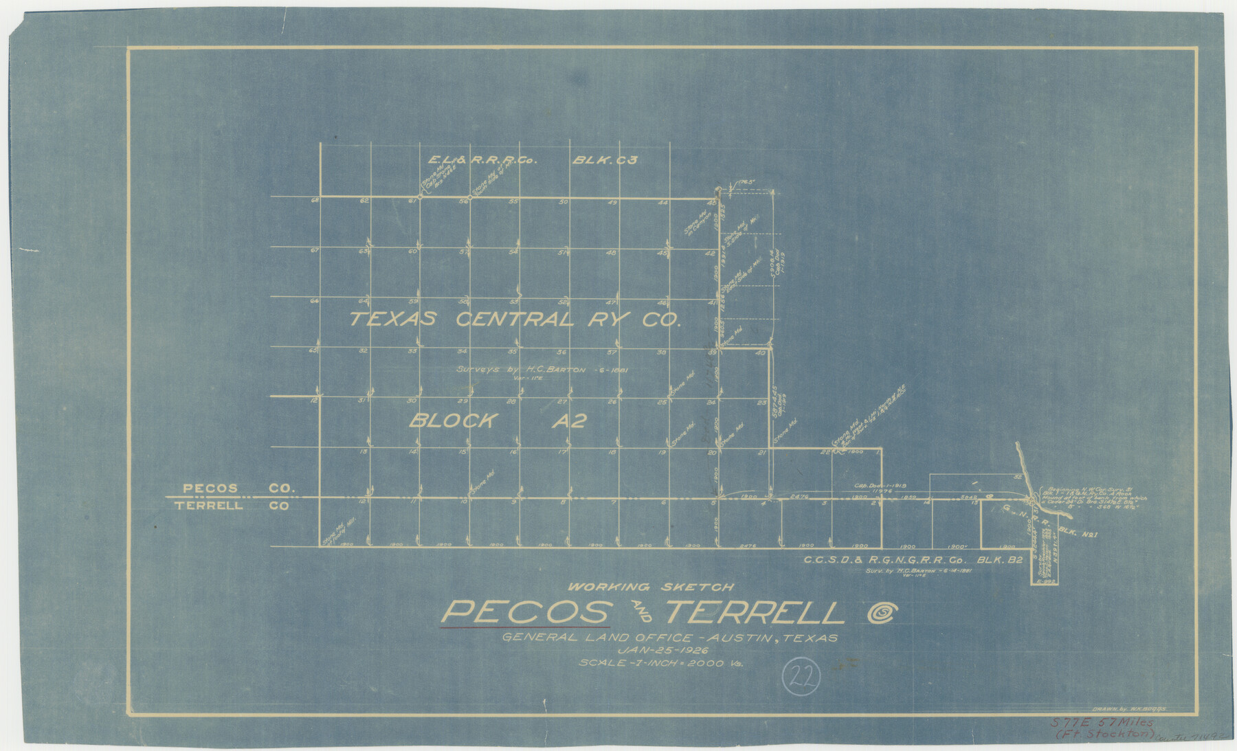
Pecos County Working Sketch 22
-
Map/Doc
71492
-
Collection
General Map Collection
-
Object Dates
1/25/1926 (Creation Date)
-
People and Organizations
W.K. Boggs (Draftsman)
-
Counties
Pecos Terrell
-
Subjects
Surveying Working Sketch
-
Height x Width
14.3 x 23.5 inches
36.3 x 59.7 cm
-
Scale
1" = 2000 varas
Part of: General Map Collection

Goliad County Working Sketch 13

Print $20.00
- Digital $50.00
Goliad County Working Sketch 13
1943
Size 28.3 x 40.8 inches
Map/Doc 63203
Hudspeth County Working Sketch 15

Print $20.00
- Digital $50.00
Hudspeth County Working Sketch 15
1954
Size 36.4 x 16.2 inches
Map/Doc 66297
Foard County Aerial Photograph Index Sheet 2

Print $20.00
- Digital $50.00
Foard County Aerial Photograph Index Sheet 2
1950
Size 22.1 x 18.8 inches
Map/Doc 83689
United States Atlantic and Gulf Coasts Including Puerto Rico and the Virgin Islands

Print $40.00
- Digital $50.00
United States Atlantic and Gulf Coasts Including Puerto Rico and the Virgin Islands
1992
Size 21.7 x 60.7 inches
Map/Doc 76123
Edwards County

Print $40.00
- Digital $50.00
Edwards County
1900
Size 56.7 x 36.3 inches
Map/Doc 87470
Blanco County Rolled Sketch 16

Print $20.00
- Digital $50.00
Blanco County Rolled Sketch 16
Size 18.8 x 19.4 inches
Map/Doc 5152
Polk County Working Sketch Graphic Index

Print $20.00
- Digital $50.00
Polk County Working Sketch Graphic Index
1943
Size 46.9 x 41.5 inches
Map/Doc 76668
Flight Mission No. DQN-5K, Frame 149, Calhoun County

Print $20.00
- Digital $50.00
Flight Mission No. DQN-5K, Frame 149, Calhoun County
1953
Size 18.5 x 22.2 inches
Map/Doc 84424
Map of Austin's Li[ttle Colony Above the] San [Antonio Road]
![215, Map of Austin's Li[ttle Colony Above the] San [Antonio Road], General Map Collection](https://historictexasmaps.com/wmedia_w700/maps/215.tif.jpg)
Print $20.00
- Digital $50.00
Map of Austin's Li[ttle Colony Above the] San [Antonio Road]
1831
Size 14.2 x 19.3 inches
Map/Doc 215
Colorado River, Twin Basin Sheet

Print $6.00
- Digital $50.00
Colorado River, Twin Basin Sheet
1941
Size 27.2 x 35.1 inches
Map/Doc 65317
Irion County Sketch File 9

Print $14.00
- Digital $50.00
Irion County Sketch File 9
1927
Size 11.0 x 8.5 inches
Map/Doc 27475
You may also like
[Stone, Kyle and Kyle Block M6]
![90414, [Stone, Kyle and Kyle Block M6], Twichell Survey Records](https://historictexasmaps.com/wmedia_w700/maps/90414-1.tif.jpg)
Print $20.00
- Digital $50.00
[Stone, Kyle and Kyle Block M6]
1908
Size 18.6 x 25.5 inches
Map/Doc 90414
Angelina County Working Sketch 19

Print $20.00
- Digital $50.00
Angelina County Working Sketch 19
1946
Size 35.8 x 39.3 inches
Map/Doc 67100

Liberty County Working Sketch 39

Print $20.00
- Digital $50.00
Liberty County Working Sketch 39
1951
Size 26.2 x 24.1 inches
Map/Doc 70498
Pecos County Sketch File 27A

Print $20.00
- Digital $50.00
Pecos County Sketch File 27A
Size 26.7 x 19.8 inches
Map/Doc 12166
Hays County Working Sketch 12

Print $20.00
- Digital $50.00
Hays County Working Sketch 12
1950
Size 22.8 x 24.3 inches
Map/Doc 66086
Castro County, Texas

Print $20.00
- Digital $50.00
Castro County, Texas
1883
Size 20.8 x 18.7 inches
Map/Doc 682
United States - Gulf Coast Texas - Northern part of Laguna Madre

Print $20.00
- Digital $50.00
United States - Gulf Coast Texas - Northern part of Laguna Madre
1941
Size 18.4 x 24.2 inches
Map/Doc 72936
[Surveys along the Sabine River made under G.W. Smyth, Commissioner]
![89, [Surveys along the Sabine River made under G.W. Smyth, Commissioner], General Map Collection](https://historictexasmaps.com/wmedia_w700/maps/89.tif.jpg)
Print $20.00
- Digital $50.00
[Surveys along the Sabine River made under G.W. Smyth, Commissioner]
Size 12.6 x 17.1 inches
Map/Doc 89
Bexar County State Real Property Sketch 3

Print $20.00
- Digital $50.00
Bexar County State Real Property Sketch 3
2000
Size 18.8 x 22.5 inches
Map/Doc 61671
Wood County Working Sketch 4

Print $20.00
- Digital $50.00
Wood County Working Sketch 4
1941
Size 21.0 x 28.3 inches
Map/Doc 62004
Corpus Christi Pass, Texas

Print $20.00
- Digital $50.00
Corpus Christi Pass, Texas
1871
Size 26.1 x 18.3 inches
Map/Doc 72981