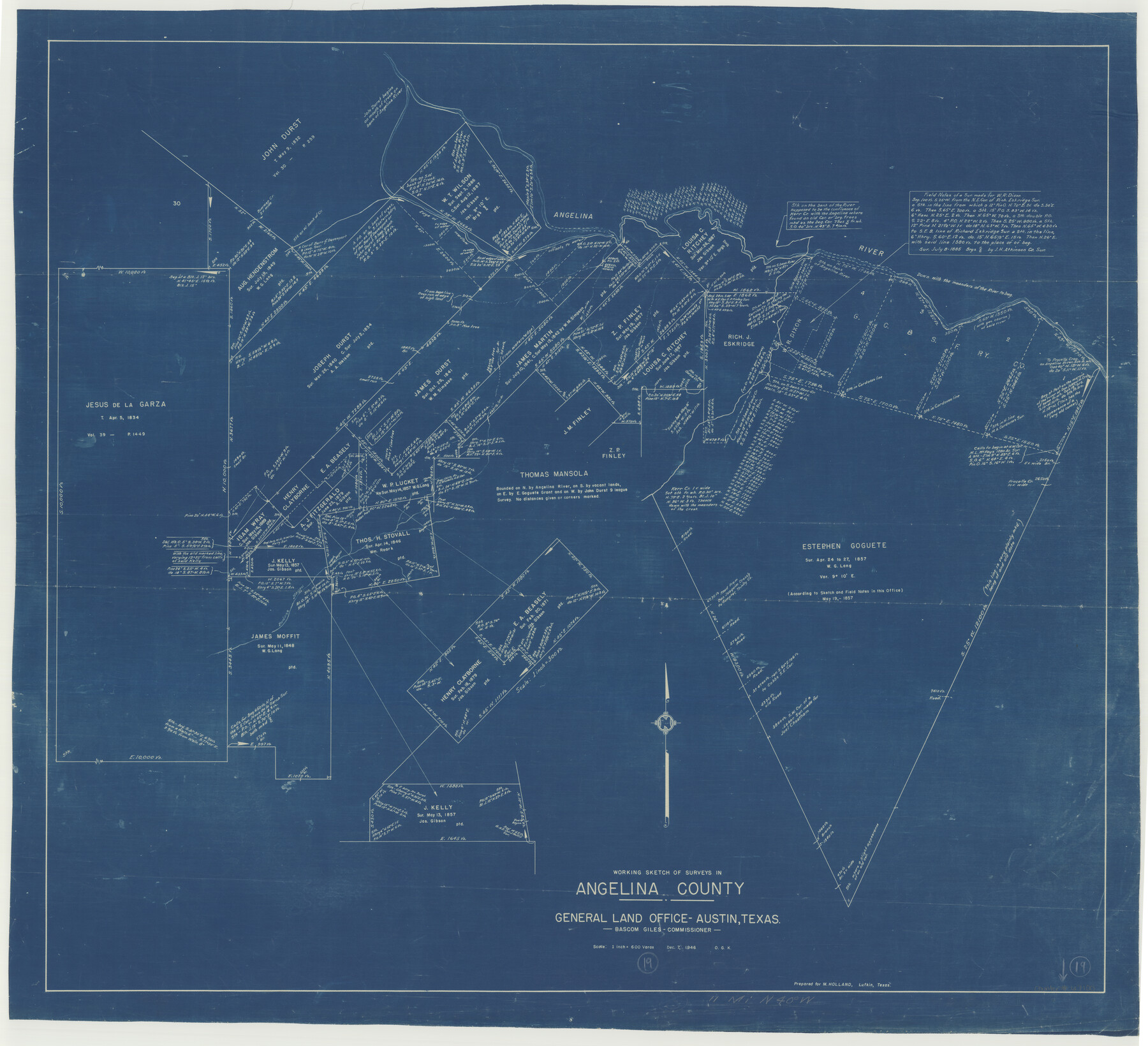
Angelina County Working Sketch 19
-
Map/Doc
67100
-
Collection
General Map Collection
-
Object Dates
12/7/1946 (Creation Date)
-
People and Organizations
Bascom Giles (GLO Commissioner)
Otto G. Kurio (Draftsman)
-
Counties
Angelina
-
Subjects
Surveying Working Sketch
-
Height x Width
35.8 x 39.3 inches
90.9 x 99.8 cm
-
Scale
1" = 600 varas
-
Comments
Surveys located about 11 miles North 40 degrees West from Lufkin, Texas.
Part of: General Map Collection
Atascosa County Working Sketch 39

Print $20.00
- Digital $50.00
Atascosa County Working Sketch 39
2011
Size 43.2 x 34.8 inches
Map/Doc 90068
Mills County Sketch File 10 1/2

Print $24.00
- Digital $50.00
Mills County Sketch File 10 1/2
1876
Size 14.4 x 17.6 inches
Map/Doc 31656
Kleberg County

Print $20.00
- Digital $50.00
Kleberg County
1913
Size 31.3 x 40.1 inches
Map/Doc 77343
Burleson County Working Sketch 8

Print $20.00
- Digital $50.00
Burleson County Working Sketch 8
1980
Size 29.3 x 23.2 inches
Map/Doc 67727
No. 1 - Survey for a road from the Brazo Santiago to the Rio Grande

Print $20.00
- Digital $50.00
No. 1 - Survey for a road from the Brazo Santiago to the Rio Grande
1847
Size 18.3 x 27.2 inches
Map/Doc 72874
Illinois, Missouri, Iowa, Wisconsin and Minnesota

Print $20.00
- Digital $50.00
Illinois, Missouri, Iowa, Wisconsin and Minnesota
1885
Size 12.2 x 9.0 inches
Map/Doc 93521
Harris County Rolled Sketch 93

Print $20.00
- Digital $50.00
Harris County Rolled Sketch 93
1983
Size 45.0 x 40.2 inches
Map/Doc 9142
Hutchinson County Working Sketch 21

Print $20.00
- Digital $50.00
Hutchinson County Working Sketch 21
1965
Size 35.0 x 40.8 inches
Map/Doc 66381
No. 3 Chart of Channel connecting Corpus Christi Bay with Aransas Bay, Texas

Print $20.00
- Digital $50.00
No. 3 Chart of Channel connecting Corpus Christi Bay with Aransas Bay, Texas
1878
Size 18.2 x 27.9 inches
Map/Doc 72774
Brown County Sketch File 11a

Print $6.00
- Digital $50.00
Brown County Sketch File 11a
1872
Size 6.6 x 3.6 inches
Map/Doc 16599
Jefferson County Sketch File 10

Print $32.00
- Digital $50.00
Jefferson County Sketch File 10
Size 8.0 x 6.8 inches
Map/Doc 28125
Hudspeth County Rolled Sketch 66

Print $20.00
- Digital $50.00
Hudspeth County Rolled Sketch 66
1973
Size 11.9 x 20.5 inches
Map/Doc 6259
You may also like
Galveston County NRC Article 33.136 Sketch 26

Print $45.00
- Digital $50.00
Galveston County NRC Article 33.136 Sketch 26
2003
Size 32.6 x 24.3 inches
Map/Doc 81943
Bee County Sketch File 2

Print $40.00
- Digital $50.00
Bee County Sketch File 2
Size 14.3 x 13.0 inches
Map/Doc 14259
Sterling County Working Sketch 4

Print $40.00
- Digital $50.00
Sterling County Working Sketch 4
1950
Size 49.7 x 42.5 inches
Map/Doc 63986
Coke County Working Sketch 11

Print $20.00
- Digital $50.00
Coke County Working Sketch 11
1945
Size 40.9 x 40.2 inches
Map/Doc 68048
Jefferson County NRC Article 33.136 Location Key Sheet

Print $20.00
- Digital $50.00
Jefferson County NRC Article 33.136 Location Key Sheet
1970
Size 27.0 x 23.0 inches
Map/Doc 77028
Archer County Sketch File 16

Print $6.00
- Digital $50.00
Archer County Sketch File 16
1889
Size 12.8 x 8.3 inches
Map/Doc 13650
Randall County Rolled Sketch 8

Print $20.00
- Digital $50.00
Randall County Rolled Sketch 8
Size 32.9 x 40.6 inches
Map/Doc 7429
[League 321, Garza County Survey 3]
![91394, [League 321, Garza County Survey 3], Twichell Survey Records](https://historictexasmaps.com/wmedia_w700/maps/91394-1.tif.jpg)
Print $20.00
- Digital $50.00
[League 321, Garza County Survey 3]
Size 12.0 x 18.7 inches
Map/Doc 91394
Coast Chart No. 209 - Aransas Pass, Aransas and Copano Bays, Texas

Print $20.00
- Digital $50.00
Coast Chart No. 209 - Aransas Pass, Aransas and Copano Bays, Texas
1889
Size 31.2 x 24.9 inches
Map/Doc 73429
Crane County Sketch File 11

Print $40.00
- Digital $50.00
Crane County Sketch File 11
Size 18.5 x 8.9 inches
Map/Doc 19569
Fractional Township No. 9 South Range No. 2 East of the Indian Meridian, Indian Territory

Print $20.00
- Digital $50.00
Fractional Township No. 9 South Range No. 2 East of the Indian Meridian, Indian Territory
1898
Size 19.1 x 24.2 inches
Map/Doc 75203
University of Texas System University Lands

Print $20.00
- Digital $50.00
University of Texas System University Lands
1937
Size 23.3 x 17.6 inches
Map/Doc 93237