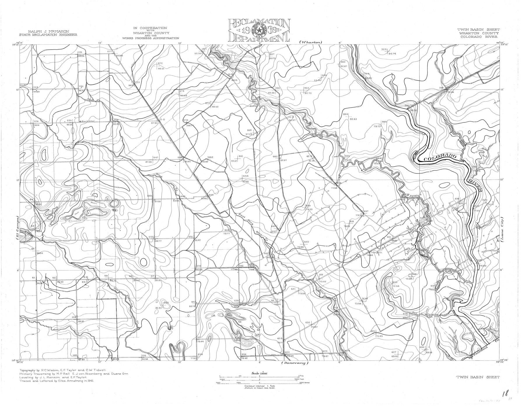
Colorado River, Twin Basin Sheet
-
Map/Doc
65317
-
Collection
General Map Collection
-
Object Dates
1941 (Creation Date)
-
People and Organizations
Texas State Reclamation Department (Publisher)
Eltea Armstrong (Compiler)
Eltea Armstrong (Draftsman)
Duane Orr (Surveyor/Engineer)
E.F. Taylor (Surveyor/Engineer)
J.L. Ransom (Surveyor/Engineer)
M.P. Ball (Surveyor/Engineer)
R.C. Wisdom (Surveyor/Engineer)
-
Counties
Wharton
-
Subjects
River Surveys Topographic
-
Height x Width
27.2 x 35.1 inches
69.1 x 89.2 cm
-
Comments
Twin Basin Sheet located south of the Wharton Sheet, east of the El Campo Sheet, west of the Lane City Sheet and north of the Danevang Sheet.
Part of: General Map Collection

State of Texas, Plate 1: Surface-Water Development, Exisiting Reservoirs and Reservoir Sites

Print $20.00
- Digital $50.00
State of Texas, Plate 1: Surface-Water Development, Exisiting Reservoirs and Reservoir Sites
1984
Size 17.8 x 18.1 inches
Map/Doc 3128
[Surveys along the Colorado River]
![49, [Surveys along the Colorado River], General Map Collection](https://historictexasmaps.com/wmedia_w700/maps/49.tif.jpg)
Print $20.00
- Digital $50.00
[Surveys along the Colorado River]
Size 28.6 x 24.0 inches
Map/Doc 49
Hudspeth County Working Sketch 65

Print $40.00
- Digital $50.00
Hudspeth County Working Sketch 65
2007
Size 32.9 x 61.6 inches
Map/Doc 88732
Llano County Working Sketch 9

Print $20.00
- Digital $50.00
Llano County Working Sketch 9
1979
Size 33.4 x 24.0 inches
Map/Doc 70627
Le Nouveau Mexique et la Floride: Tirèes de diverses cartes, et relations

Print $20.00
- Digital $50.00
Le Nouveau Mexique et la Floride: Tirèes de diverses cartes, et relations
Size 17.2 x 22.8 inches
Map/Doc 95833
Central & Montgomery

Print $40.00
- Digital $50.00
Central & Montgomery
1941
Size 26.1 x 123.0 inches
Map/Doc 64523
United States - Gulf Coast - Aransas Pass and Corpus Christi Bay with the coast to latitude 27° 12' Texas

Print $20.00
- Digital $50.00
United States - Gulf Coast - Aransas Pass and Corpus Christi Bay with the coast to latitude 27° 12' Texas
1913
Size 27.6 x 18.2 inches
Map/Doc 72793
Limestone County Sketch File 3

Print $4.00
- Digital $50.00
Limestone County Sketch File 3
1850
Size 7.9 x 10.7 inches
Map/Doc 30158
Survey of Mustang Is., Joseph's and a part of Matagorda Island.

Print $20.00
- Digital $50.00
Survey of Mustang Is., Joseph's and a part of Matagorda Island.
1834
Size 19.5 x 20.2 inches
Map/Doc 3183
Eastland County Working Sketch 36

Print $20.00
- Digital $50.00
Eastland County Working Sketch 36
1963
Size 24.0 x 40.0 inches
Map/Doc 68817
Jeff Davis County Working Sketch 15

Print $20.00
- Digital $50.00
Jeff Davis County Working Sketch 15
1950
Size 34.6 x 29.0 inches
Map/Doc 66510
You may also like
Cochran County

Print $20.00
- Digital $50.00
Cochran County
1899
Size 40.9 x 32.6 inches
Map/Doc 4744
[Panhandle Counties]
![92067, [Panhandle Counties], Twichell Survey Records](https://historictexasmaps.com/wmedia_w700/maps/92067-1.tif.jpg)
Print $2.00
- Digital $50.00
[Panhandle Counties]
Size 12.3 x 9.1 inches
Map/Doc 92067
McMullen County Sketch File 47

Print $20.00
- Digital $50.00
McMullen County Sketch File 47
1989
Size 24.6 x 21.5 inches
Map/Doc 12066
Flight Mission No. BRA-8M, Frame 122, Jefferson County

Print $20.00
- Digital $50.00
Flight Mission No. BRA-8M, Frame 122, Jefferson County
1953
Size 18.5 x 22.4 inches
Map/Doc 85618
Donley County Sketch File B8

Print $20.00
- Digital $50.00
Donley County Sketch File B8
1920
Size 15.3 x 15.9 inches
Map/Doc 11378
Angelina County Sketch File 17a

Print $8.00
- Digital $50.00
Angelina County Sketch File 17a
1863
Size 13.1 x 8.2 inches
Map/Doc 13024
Souvenir of Galveston the Sea Wall City

Souvenir of Galveston the Sea Wall City
Size 5.7 x 7.6 inches
Map/Doc 97051
Map of the chief part of the Western States and part of Virginia engraved to illustrate Mitchell's school and family geography

Print $20.00
- Digital $50.00
Map of the chief part of the Western States and part of Virginia engraved to illustrate Mitchell's school and family geography
1839
Size 11.8 x 17.8 inches
Map/Doc 93499
[Map of Polk County]
![4614, [Map of Polk County], General Map Collection](https://historictexasmaps.com/wmedia_w700/maps/4614-1.tif.jpg)
Print $20.00
- Digital $50.00
[Map of Polk County]
Size 21.7 x 25.8 inches
Map/Doc 4614
Littlef[ield], Lamb [County]
![93126, Littlef[ield], Lamb [County], Twichell Survey Records](https://historictexasmaps.com/wmedia_w700/maps/93126-1.tif.jpg)
Print $20.00
- Digital $50.00
Littlef[ield], Lamb [County]
Size 42.9 x 38.5 inches
Map/Doc 93126
Revised Sectional Map No. 3 showing land surveys in counties of Loving, Reeves and Culberson and portions of Winkler, Ward, Pecos and Jeff Davis, Texas

Print $20.00
- Digital $50.00
Revised Sectional Map No. 3 showing land surveys in counties of Loving, Reeves and Culberson and portions of Winkler, Ward, Pecos and Jeff Davis, Texas
Size 19.0 x 24.7 inches
Map/Doc 4478
Kinney County Boundary File 1

Print $94.00
- Digital $50.00
Kinney County Boundary File 1
Size 20.3 x 3.7 inches
Map/Doc 64935