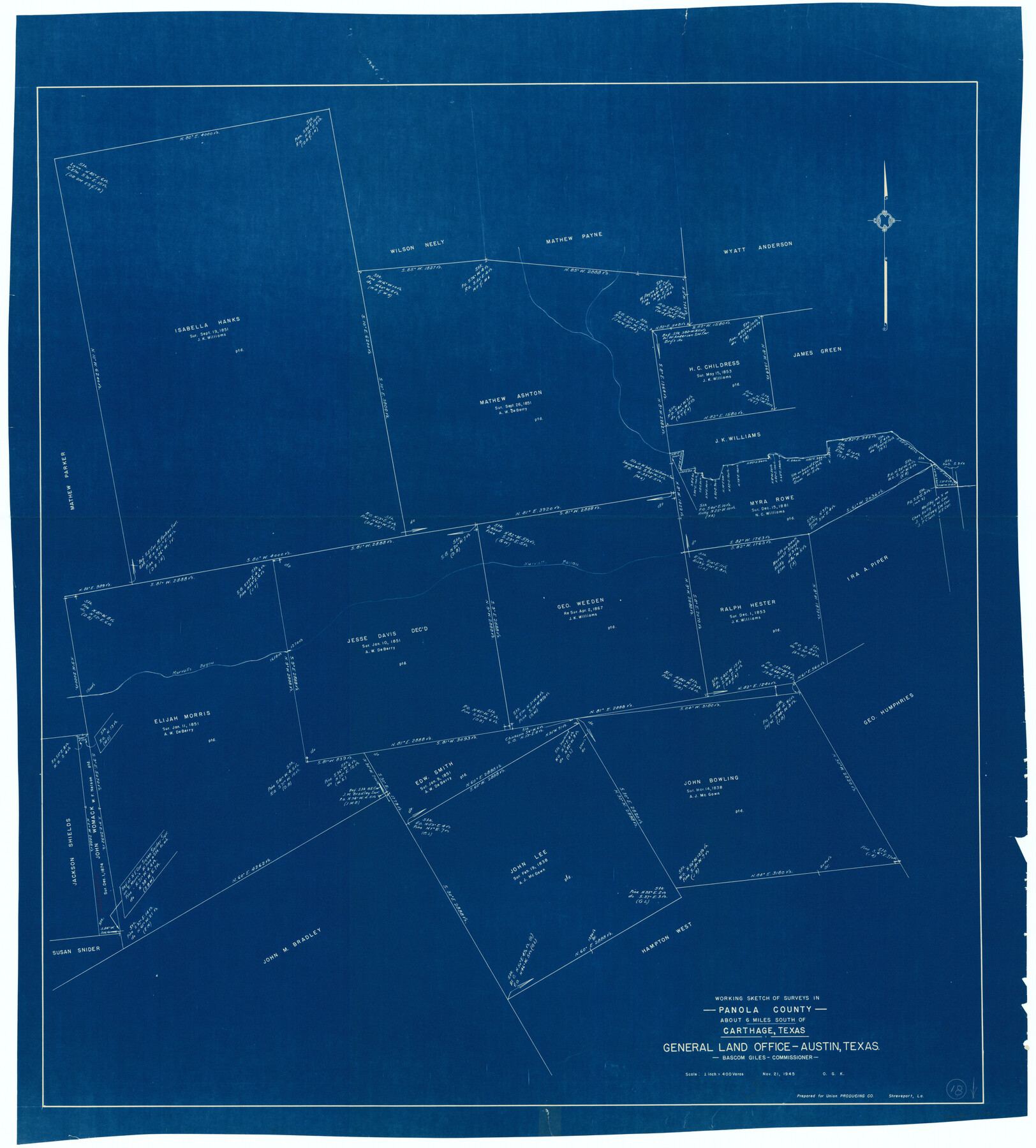
Panola County Working Sketch 18
-
Map/Doc
71427
-
Collection
General Map Collection
-
Object Dates
11/21/1945 (Creation Date)
-
People and Organizations
Otto G. Kurio (Draftsman)
-
Counties
Panola
-
Subjects
Surveying Working Sketch
-
Scale
1" = 400 varas
Part of: General Map Collection
Cherokee County Boundary File 2

Print $11.00
- Digital $50.00
Cherokee County Boundary File 2
Size 16.1 x 9.9 inches
Map/Doc 51280

Flight Mission No. DQO-1K, Frame 148, Galveston County

Print $20.00
- Digital $50.00
Flight Mission No. DQO-1K, Frame 148, Galveston County
1952
Size 18.8 x 22.5 inches
Map/Doc 85001
Hidalgo County Sketch File 2

Print $14.00
- Digital $50.00
Hidalgo County Sketch File 2
1877
Size 10.1 x 8.1 inches
Map/Doc 26394

Hutchinson County Sketch File 48

Print $38.00
- Digital $50.00
Hutchinson County Sketch File 48
1989
Size 11.2 x 8.8 inches
Map/Doc 27400
Culberson County Sketch File 33

Print $10.00
- Digital $50.00
Culberson County Sketch File 33
Size 11.2 x 8.8 inches
Map/Doc 20286
Somervell County

Print $20.00
- Digital $50.00
Somervell County
1941
Size 25.1 x 24.1 inches
Map/Doc 77424
Jefferson County Rolled Sketch 50

Print $20.00
- Digital $50.00
Jefferson County Rolled Sketch 50
Size 34.2 x 41.6 inches
Map/Doc 9306
Coke County Working Sketch 3

Print $20.00
- Digital $50.00
Coke County Working Sketch 3
1890
Size 22.3 x 29.2 inches
Map/Doc 68040
Hudspeth County Sketch File 47

Print $30.00
- Digital $50.00
Hudspeth County Sketch File 47
1978
Size 14.5 x 8.9 inches
Map/Doc 27050
Bailey County Sketch File 15

Print $18.00
- Digital $50.00
Bailey County Sketch File 15
1912
Size 8.7 x 11.2 inches
Map/Doc 13975
You may also like
Kaufman County Working Sketch 5

Print $20.00
- Digital $50.00
Kaufman County Working Sketch 5
1922
Size 31.8 x 46.0 inches
Map/Doc 66668
McMullen County Sketch File 11

Print $4.00
- Digital $50.00
McMullen County Sketch File 11
1876
Size 7.3 x 8.4 inches
Map/Doc 31355
Polk County Sketch File 32

Print $8.00
- Digital $50.00
Polk County Sketch File 32
1887
Size 12.8 x 8.0 inches
Map/Doc 34226
Wilbarger Co.

Print $40.00
- Digital $50.00
Wilbarger Co.
1949
Size 48.2 x 39.2 inches
Map/Doc 63128
Presidio County Sketch File G

Print $6.00
- Digital $50.00
Presidio County Sketch File G
1913
Size 9.7 x 17.0 inches
Map/Doc 34429
Flight Mission No. DQN-1K, Frame 141, Calhoun County

Print $20.00
- Digital $50.00
Flight Mission No. DQN-1K, Frame 141, Calhoun County
1953
Size 18.5 x 22.1 inches
Map/Doc 84204
Flight Mission No. CLL-3N, Frame 19, Willacy County

Print $20.00
- Digital $50.00
Flight Mission No. CLL-3N, Frame 19, Willacy County
1954
Size 18.4 x 22.1 inches
Map/Doc 87085
Galveston County NRC Article 33.136 Sketch 65

Print $28.00
- Digital $50.00
Galveston County NRC Article 33.136 Sketch 65
2012
Size 24.0 x 36.0 inches
Map/Doc 93328
Harris County Rolled Sketch 79

Print $20.00
- Digital $50.00
Harris County Rolled Sketch 79
1955
Size 30.4 x 25.0 inches
Map/Doc 6115
Greenville, Tex., County Seat of Hunt County

Print $20.00
Greenville, Tex., County Seat of Hunt County
1886
Size 17.3 x 24.9 inches
Map/Doc 89089
Aransas County NRC Article 33.136 Sketch 5

Print $20.00
- Digital $50.00
Aransas County NRC Article 33.136 Sketch 5
2005
Size 18.5 x 24.7 inches
Map/Doc 83521
Flight Mission No. DQN-1K, Frame 144, Calhoun County

Print $20.00
- Digital $50.00
Flight Mission No. DQN-1K, Frame 144, Calhoun County
1953
Size 18.5 x 22.2 inches
Map/Doc 84207