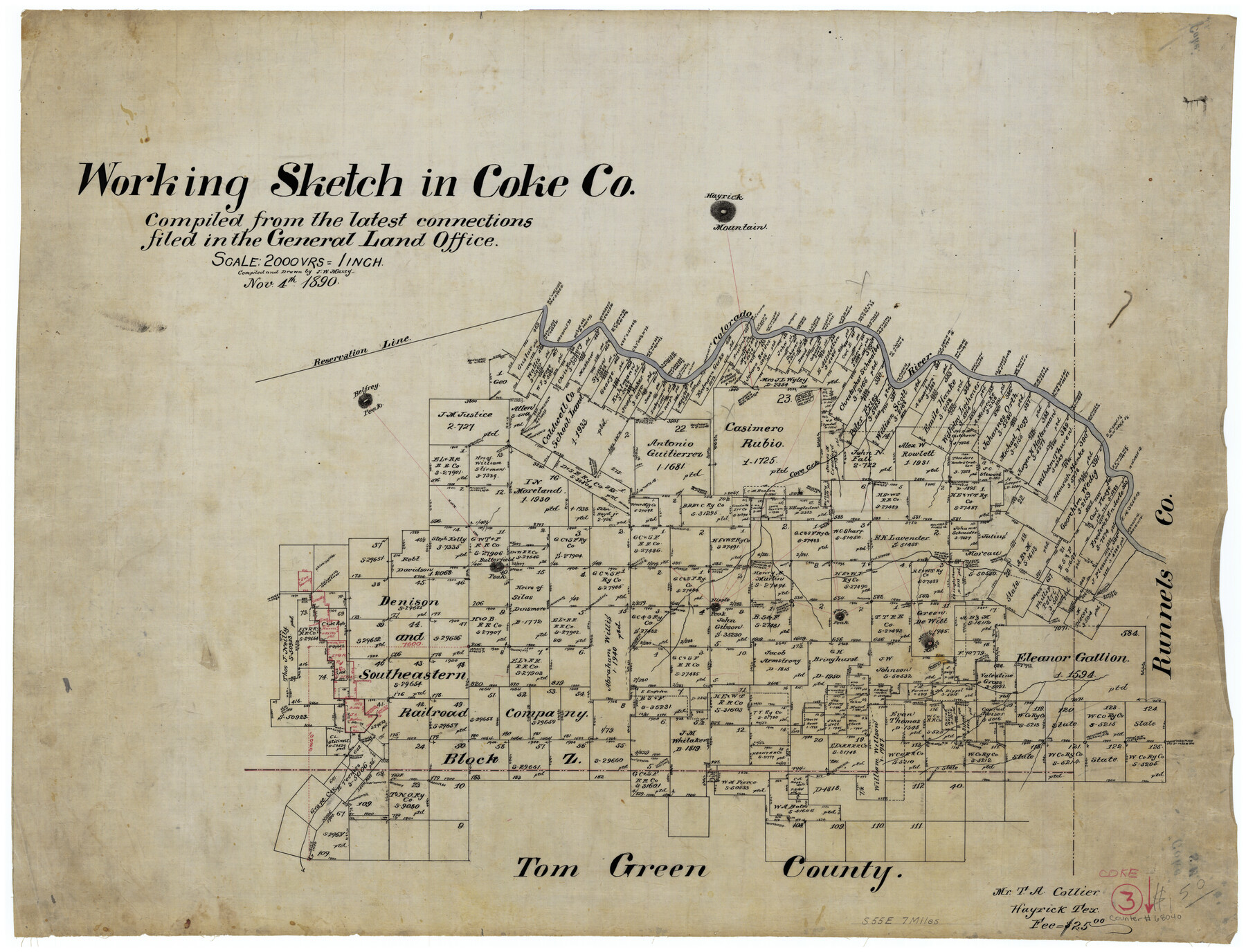
Coke County Working Sketch 3
-
Map/Doc
68040
-
Collection
General Map Collection
-
Object Dates
11/4/1890 (Creation Date)
-
People and Organizations
J.W. Maxcy (Draftsman)
-
Counties
Coke
-
Subjects
Surveying Working Sketch
-
Height x Width
22.3 x 29.2 inches
56.6 x 74.2 cm
-
Scale
1" = 2000 varas
Part of: General Map Collection
Fayette County Boundary File 6

Print $20.00
- Digital $50.00
Fayette County Boundary File 6
Size 14.4 x 9.0 inches
Map/Doc 53391
Live Oak County

Print $40.00
- Digital $50.00
Live Oak County
1899
Size 52.1 x 37.5 inches
Map/Doc 78423
Crockett County Rolled Sketch 79

Print $40.00
- Digital $50.00
Crockett County Rolled Sketch 79
1954
Size 37.3 x 48.3 inches
Map/Doc 8724
Neches River, Watershed of the Neches River

Print $6.00
- Digital $50.00
Neches River, Watershed of the Neches River
1925
Size 34.6 x 28.3 inches
Map/Doc 65085
Pecos County Working Sketch 113

Print $40.00
- Digital $50.00
Pecos County Working Sketch 113
1972
Size 36.1 x 58.2 inches
Map/Doc 71586
Western Waters of the Clear Fork of the Brazos River below Phantom-Hill

Print $20.00
- Digital $50.00
Western Waters of the Clear Fork of the Brazos River below Phantom-Hill
1857
Size 16.0 x 12.5 inches
Map/Doc 4664
Harris County Historic Topographic 22

Print $20.00
- Digital $50.00
Harris County Historic Topographic 22
1915
Size 29.2 x 22.7 inches
Map/Doc 65833
Orange County Working Sketch 46

Print $3.00
- Digital $50.00
Orange County Working Sketch 46
1982
Size 10.8 x 9.9 inches
Map/Doc 71378
Foard County Sketch File 30

Print $6.00
- Digital $50.00
Foard County Sketch File 30
Size 9.1 x 8.2 inches
Map/Doc 22858
Liberty County Sketch File 56

Print $20.00
- Digital $50.00
Liberty County Sketch File 56
Size 11.9 x 18.7 inches
Map/Doc 11996
Parker County Working Sketch 24

Print $20.00
- Digital $50.00
Parker County Working Sketch 24
2008
Map/Doc 88814
Maps of Gulf Intracoastal Waterway, Texas - Sabine River to the Rio Grande and connecting waterways including ship channels

Print $20.00
- Digital $50.00
Maps of Gulf Intracoastal Waterway, Texas - Sabine River to the Rio Grande and connecting waterways including ship channels
1966
Size 14.5 x 22.2 inches
Map/Doc 61960
You may also like
Map of the United States Exhibiting the grants of lands made by the general government to aid in the construction of railroads and wagon roads

Print $20.00
Map of the United States Exhibiting the grants of lands made by the general government to aid in the construction of railroads and wagon roads
1878
Size 20.8 x 29.4 inches
Map/Doc 95286
Terry County Sketch File 19

Print $6.00
- Digital $50.00
Terry County Sketch File 19
1998
Size 11.2 x 8.9 inches
Map/Doc 38047
Intracoastal Waterway in Texas - Corpus Christi to Point Isabel including Arroyo Colorado to Mo. Pac. R.R. Bridge Near Harlingen

Print $20.00
- Digital $50.00
Intracoastal Waterway in Texas - Corpus Christi to Point Isabel including Arroyo Colorado to Mo. Pac. R.R. Bridge Near Harlingen
1933
Size 28.1 x 41.4 inches
Map/Doc 61871
Parker County Sketch File 27

Print $20.00
- Digital $50.00
Parker County Sketch File 27
1876
Size 23.7 x 23.8 inches
Map/Doc 12146
Hemphill County Texas

Print $20.00
- Digital $50.00
Hemphill County Texas
Size 21.9 x 24.6 inches
Map/Doc 92183
Brewster County Rolled Sketch 91

Print $20.00
- Digital $50.00
Brewster County Rolled Sketch 91
1949
Size 27.5 x 15.3 inches
Map/Doc 5249
Kimble County Working Sketch 4

Print $20.00
- Digital $50.00
Kimble County Working Sketch 4
1913
Size 26.8 x 21.7 inches
Map/Doc 70072
The Republic County of Bowie. Created, December 17, 1840

Print $20.00
The Republic County of Bowie. Created, December 17, 1840
2020
Size 19.5 x 21.7 inches
Map/Doc 96102
Reeves County Working Sketch 13

Print $20.00
- Digital $50.00
Reeves County Working Sketch 13
1959
Size 30.5 x 33.4 inches
Map/Doc 63456
Flight Mission No. BRA-7M, Frame 33, Jefferson County

Print $20.00
- Digital $50.00
Flight Mission No. BRA-7M, Frame 33, Jefferson County
1953
Size 18.6 x 22.4 inches
Map/Doc 85484
Flight Mission No. DQO-8K, Frame 48, Galveston County

Print $20.00
- Digital $50.00
Flight Mission No. DQO-8K, Frame 48, Galveston County
1952
Size 18.7 x 22.2 inches
Map/Doc 85155
Calhoun County Aerial Photograph Index Sheet 1

Print $20.00
- Digital $50.00
Calhoun County Aerial Photograph Index Sheet 1
1953
Size 23.7 x 19.7 inches
Map/Doc 83670