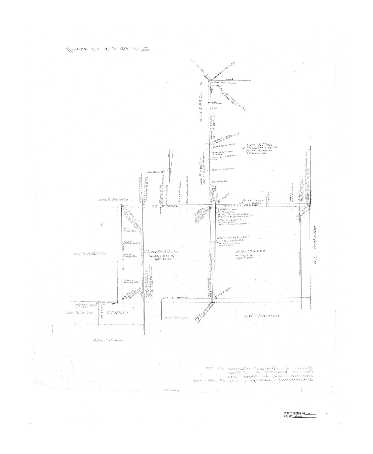
Harris County Rolled Sketch 79
[Office Sketch showing Chas. W. Adams and surrounding surveys, Harris County, Texas]
-
Map/Doc
6115
-
Collection
General Map Collection
-
Object Dates
1955/8/9 (Creation Date)
-
People and Organizations
C.R. Hale (Draftsman)
-
Counties
Harris
-
Subjects
Surveying Rolled Sketch
-
Height x Width
30.4 x 25.0 inches
77.2 x 63.5 cm
Part of: General Map Collection
Duval County Rolled Sketch Pressly No. 2

Print $20.00
- Digital $50.00
Duval County Rolled Sketch Pressly No. 2
1935
Size 22.6 x 33.7 inches
Map/Doc 5770
Montgomery County Working Sketch 32

Print $20.00
- Digital $50.00
Montgomery County Working Sketch 32
1950
Size 32.8 x 32.8 inches
Map/Doc 71139
Flight Mission No. BRA-16M, Frame 174, Jefferson County

Print $20.00
- Digital $50.00
Flight Mission No. BRA-16M, Frame 174, Jefferson County
1953
Size 18.6 x 22.4 inches
Map/Doc 85772
Andrews County Sketch File 8a

Print $8.00
- Digital $50.00
Andrews County Sketch File 8a
1943
Size 11.3 x 8.8 inches
Map/Doc 12849
Eastland County Working Sketch 48

Print $20.00
- Digital $50.00
Eastland County Working Sketch 48
1981
Size 35.1 x 25.5 inches
Map/Doc 68829
Coryell County Boundary File 1b

Print $68.00
- Digital $50.00
Coryell County Boundary File 1b
Size 18.1 x 16.1 inches
Map/Doc 51894
Flight Mission No. BRE-1P, Frame 147, Nueces County

Print $20.00
- Digital $50.00
Flight Mission No. BRE-1P, Frame 147, Nueces County
1956
Size 18.5 x 22.3 inches
Map/Doc 86707
Crockett County Rolled Sketch 56

Print $20.00
- Digital $50.00
Crockett County Rolled Sketch 56
1944
Size 24.2 x 31.1 inches
Map/Doc 5599
Wichita County Sketch File 1

Print $22.00
- Digital $50.00
Wichita County Sketch File 1
1856
Size 13.5 x 16.8 inches
Map/Doc 40028
Dimmit County Sketch File 10

Print $20.00
- Digital $50.00
Dimmit County Sketch File 10
Size 23.5 x 22.6 inches
Map/Doc 11338
Right of Way and Track Map, The Missouri, Kansas and Texas Ry. of Texas operated by the Missouri, Kansas and Texas Ry. of Texas, Henrietta Division

Print $40.00
- Digital $50.00
Right of Way and Track Map, The Missouri, Kansas and Texas Ry. of Texas operated by the Missouri, Kansas and Texas Ry. of Texas, Henrietta Division
1918
Size 25.4 x 57.2 inches
Map/Doc 64073
Town Site of Marilou on Lake Placedo, Victoria County, Texas

Print $20.00
- Digital $50.00
Town Site of Marilou on Lake Placedo, Victoria County, Texas
1909
Size 17.0 x 22.6 inches
Map/Doc 77092
You may also like
Runnels County Sketch File 31

Print $6.00
Runnels County Sketch File 31
1950
Size 11.5 x 8.8 inches
Map/Doc 35496
Jackson County Sketch File 21

Print $70.00
- Digital $50.00
Jackson County Sketch File 21
2000
Size 11.3 x 8.8 inches
Map/Doc 27673
Flight Mission No. DQN-1K, Frame 135, Calhoun County

Print $20.00
- Digital $50.00
Flight Mission No. DQN-1K, Frame 135, Calhoun County
1953
Size 18.3 x 22.4 inches
Map/Doc 84198

Sutton County Working Sketch 12

Print $40.00
- Digital $50.00
Sutton County Working Sketch 12
1972
Size 66.8 x 37.3 inches
Map/Doc 62355
Reagan County Sketch File 34

Print $4.00
- Digital $50.00
Reagan County Sketch File 34
Size 11.5 x 8.9 inches
Map/Doc 35030
Chambers County Sketch File A

Print $20.00
- Digital $50.00
Chambers County Sketch File A
1900
Size 21.3 x 21.5 inches
Map/Doc 11071
Harris County Working Sketch 29

Print $20.00
- Digital $50.00
Harris County Working Sketch 29
1934
Size 22.6 x 30.5 inches
Map/Doc 65921
Flight Mission No. DIX-8P, Frame 91, Aransas County

Print $20.00
- Digital $50.00
Flight Mission No. DIX-8P, Frame 91, Aransas County
1956
Size 18.5 x 22.4 inches
Map/Doc 83916
Crockett County Working Sketch 17

Print $20.00
- Digital $50.00
Crockett County Working Sketch 17
1918
Size 17.9 x 24.6 inches
Map/Doc 68350
[Sketch of Surveys Near Port Aransas and Aransas Pass, Aransas County, Texas]
![676, [Sketch of Surveys Near Port Aransas and Aransas Pass, Aransas County, Texas], Maddox Collection](https://historictexasmaps.com/wmedia_w700/maps/676.tif.jpg)
Print $20.00
- Digital $50.00
[Sketch of Surveys Near Port Aransas and Aransas Pass, Aransas County, Texas]
Size 22.8 x 18.5 inches
Map/Doc 676
Coleman County Sketch File 45a

Print $4.00
- Digital $50.00
Coleman County Sketch File 45a
1897
Size 9.8 x 6.2 inches
Map/Doc 18791