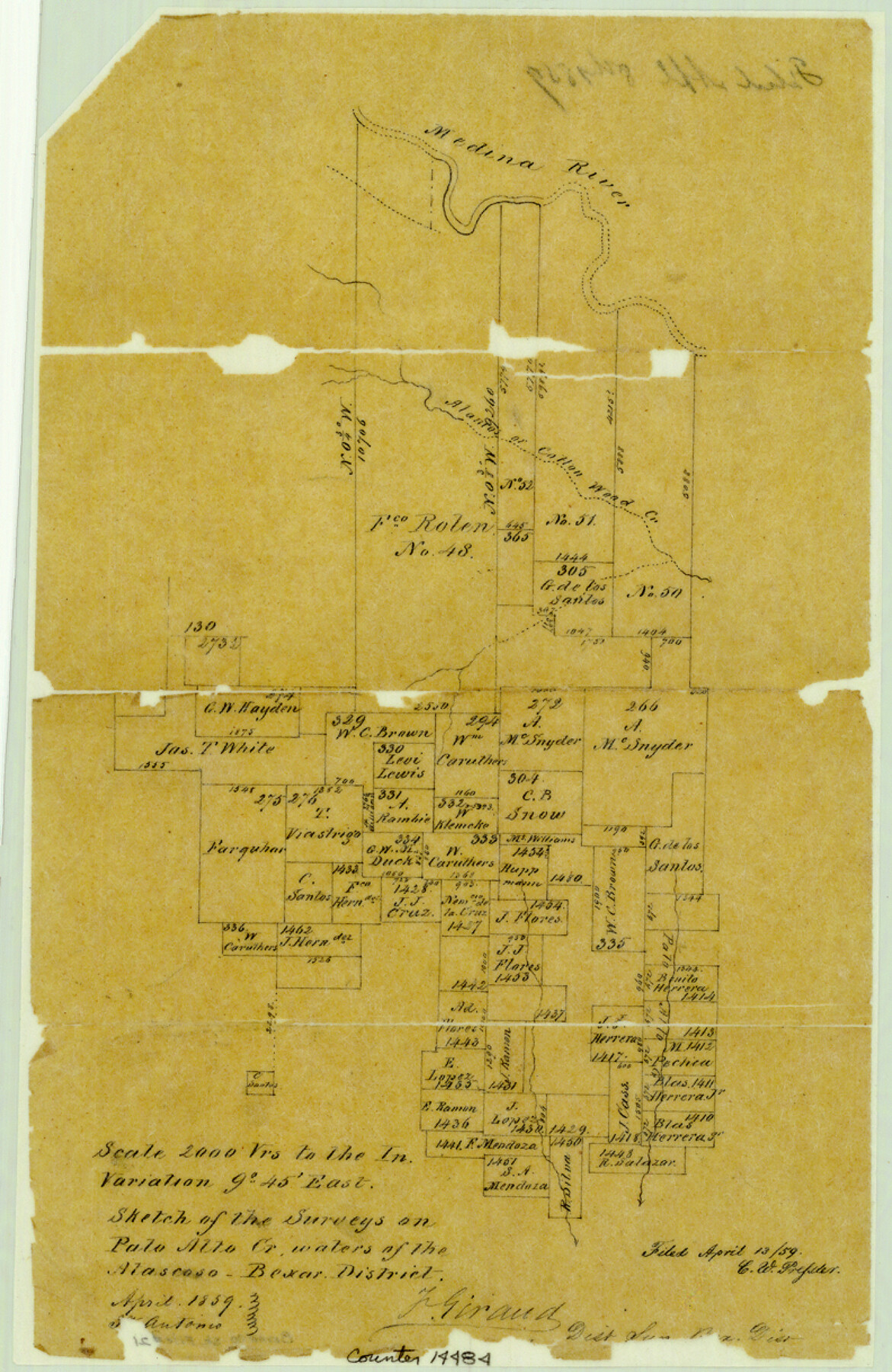
Bexar County Sketch File 21
[Sketch of area south of the Medina River southwest of San Antonio]
-
Map/Doc
14484
-
Collection
General Map Collection
-
Object Dates
1859 (Creation Date)
1859/4/13 (File Date)
-
People and Organizations
F. Giraud (Surveyor/Engineer)
-
Counties
Bexar Atascosa
-
Subjects
Surveying Sketch File
-
Height x Width
12.2 x 7.9 inches
31.0 x 20.1 cm
-
Medium
paper, manuscript
-
Scale
1" = 2000 varas
-
Features
Medina River
Alamos or Cotton Wood Creek
Alamos Creek
Cotton Wood Creek
Palo Alto Creek
Part of: General Map Collection
Trinity County Sketch File 21

Print $20.00
- Digital $50.00
Trinity County Sketch File 21
Size 22.2 x 34.5 inches
Map/Doc 12486
Map of Bosque County

Print $20.00
- Digital $50.00
Map of Bosque County
1869
Size 24.1 x 23.7 inches
Map/Doc 3313
Flight Mission No. DAG-24K, Frame 41, Matagorda County

Print $20.00
- Digital $50.00
Flight Mission No. DAG-24K, Frame 41, Matagorda County
1953
Size 18.5 x 22.4 inches
Map/Doc 86528
Floyd County Rolled Sketch 7

Print $3.00
- Digital $50.00
Floyd County Rolled Sketch 7
Size 8.7 x 13.9 inches
Map/Doc 5881
Presidio County Rolled Sketch 3B

Print $20.00
- Digital $50.00
Presidio County Rolled Sketch 3B
Size 26.2 x 24.1 inches
Map/Doc 7328
Oldham County Working Sketch 8

Print $20.00
- Digital $50.00
Oldham County Working Sketch 8
1982
Size 33.4 x 35.8 inches
Map/Doc 71330
Bosque County Sketch File 20

Print $4.00
- Digital $50.00
Bosque County Sketch File 20
1863
Size 11.8 x 7.7 inches
Map/Doc 14796
Flight Mission No. DQN-5K, Frame 50, Calhoun County

Print $20.00
- Digital $50.00
Flight Mission No. DQN-5K, Frame 50, Calhoun County
1953
Size 18.5 x 22.3 inches
Map/Doc 84395
El Paso County Sketch File 28

Print $18.00
- Digital $50.00
El Paso County Sketch File 28
1939
Size 15.2 x 9.5 inches
Map/Doc 22070
Taylor County Sketch File 12

Print $4.00
- Digital $50.00
Taylor County Sketch File 12
Size 8.6 x 12.8 inches
Map/Doc 37796

Flight Mission No. DQN-1K, Frame 154, Calhoun County

Print $20.00
- Digital $50.00
Flight Mission No. DQN-1K, Frame 154, Calhoun County
1953
Size 18.7 x 22.4 inches
Map/Doc 84213
You may also like
Karnes County, Texas

Print $20.00
- Digital $50.00
Karnes County, Texas
1880
Size 28.9 x 23.0 inches
Map/Doc 524
[Copy of a portion of] The Coast & Bays of Western Texas, St. Joseph's and Mustang Islands from Actual Survey, the Remainder from County Maps, Etc.
![72769, [Copy of a portion of] The Coast & Bays of Western Texas, St. Joseph's and Mustang Islands from Actual Survey, the Remainder from County Maps, Etc., General Map Collection](https://historictexasmaps.com/wmedia_w700/maps/72769.tif.jpg)
Print $20.00
- Digital $50.00
[Copy of a portion of] The Coast & Bays of Western Texas, St. Joseph's and Mustang Islands from Actual Survey, the Remainder from County Maps, Etc.
1857
Size 25.9 x 18.3 inches
Map/Doc 72769
Map of Ramsey State Farm

Print $20.00
- Digital $50.00
Map of Ramsey State Farm
1934
Size 30.3 x 38.0 inches
Map/Doc 94284
Castro County, Texas

Print $20.00
- Digital $50.00
Castro County, Texas
1891
Size 24.5 x 20.4 inches
Map/Doc 694

Harris County NRC Article 33.136 Location Key Sheet

Print $20.00
- Digital $50.00
Harris County NRC Article 33.136 Location Key Sheet
1995
Size 27.0 x 21.8 inches
Map/Doc 77027
Calhoun County Sketch File 1

Print $7.00
- Digital $50.00
Calhoun County Sketch File 1
1855
Size 17.1 x 11.0 inches
Map/Doc 11031
Live Oak County Sketch File 22

Print $20.00
- Digital $50.00
Live Oak County Sketch File 22
Size 17.4 x 9.7 inches
Map/Doc 30299
Atascosa County Boundary File 7

Print $20.00
- Digital $50.00
Atascosa County Boundary File 7
Size 8.2 x 10.1 inches
Map/Doc 50213
Nueces County Rolled Sketch 32

Print $20.00
- Digital $50.00
Nueces County Rolled Sketch 32
Size 17.0 x 17.2 inches
Map/Doc 6876
Tabula Terre Nove

Print $20.00
- Digital $50.00
Tabula Terre Nove
1513
Size 18.7 x 24.6 inches
Map/Doc 93800
San Jacinto County Sketch File 11

Print $4.00
San Jacinto County Sketch File 11
1859
Size 9.4 x 7.3 inches
Map/Doc 35718