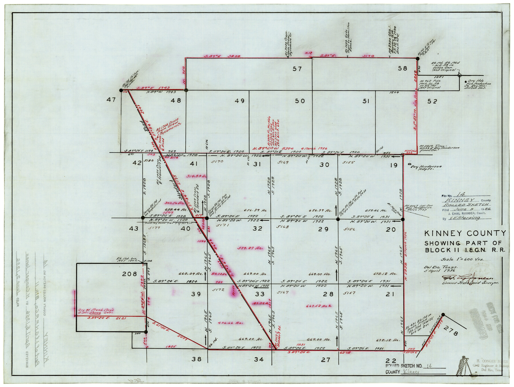
Kinney County Rolled Sketch 14
Kinney County showing part of Block 11, I. & G. N. R.R.
-
Map/Doc
6543
-
Collection
General Map Collection
-
Object Dates
4/5/1956 (Creation Date)
6/9/1956 (File Date)
-
People and Organizations
H. Conger Jones (Surveyor/Engineer)
-
Counties
Kinney
-
Subjects
Surveying Rolled Sketch
-
Height x Width
19.5 x 25.8 inches
49.5 x 65.5 cm
-
Medium
linen, manuscript
-
Scale
1" = 600 varas
Part of: General Map Collection
Liberty County Working Sketch Graphic Index - east part

Print $20.00
- Digital $50.00
Liberty County Working Sketch Graphic Index - east part
1977
Size 46.0 x 34.5 inches
Map/Doc 76620
Comanche County Sketch File 12

Print $4.00
- Digital $50.00
Comanche County Sketch File 12
1859
Size 8.5 x 15.2 inches
Map/Doc 19074
Donley County Sketch File 7

Print $20.00
- Digital $50.00
Donley County Sketch File 7
Size 38.3 x 38.2 inches
Map/Doc 10367
Book of Photostatic Copies of Plats for Texas and Pacific Ry. Co. Lands

Digital $50.00
Book of Photostatic Copies of Plats for Texas and Pacific Ry. Co. Lands
Map/Doc 2222
Flight Mission No. CGI-1N, Frame 219, Cameron County

Print $20.00
- Digital $50.00
Flight Mission No. CGI-1N, Frame 219, Cameron County
1955
Size 18.6 x 22.2 inches
Map/Doc 84528
Presidio County Rolled Sketch 126

Print $20.00
- Digital $50.00
Presidio County Rolled Sketch 126
1986
Size 27.8 x 39.4 inches
Map/Doc 7397
Eastland County Working Sketch 60

Print $20.00
- Digital $50.00
Eastland County Working Sketch 60
1989
Size 25.5 x 19.5 inches
Map/Doc 68841
Edwards County Rolled Sketch 18

Print $20.00
- Digital $50.00
Edwards County Rolled Sketch 18
1947
Size 21.8 x 21.2 inches
Map/Doc 5807
Glasscock County Sketch File 3

Print $3.00
- Digital $50.00
Glasscock County Sketch File 3
1931
Size 11.1 x 14.8 inches
Map/Doc 11560
Flight Mission No. DQN-2K, Frame 28, Calhoun County

Print $20.00
- Digital $50.00
Flight Mission No. DQN-2K, Frame 28, Calhoun County
1953
Size 18.6 x 22.2 inches
Map/Doc 84235

Brewster County Working Sketch 117

Print $20.00
- Digital $50.00
Brewster County Working Sketch 117
1988
Size 33.3 x 37.0 inches
Map/Doc 67717
You may also like
Map of Shackelford County, Texas

Print $20.00
- Digital $50.00
Map of Shackelford County, Texas
1879
Size 28.7 x 23.4 inches
Map/Doc 616

Starr County Boundary File 1a

Print $20.00
- Digital $50.00
Starr County Boundary File 1a
Size 22.4 x 41.0 inches
Map/Doc 58813
Eastland County Working Sketch 54

Print $20.00
- Digital $50.00
Eastland County Working Sketch 54
1984
Size 19.6 x 18.0 inches
Map/Doc 68835
Resurvey of Block K-3

Print $20.00
- Digital $50.00
Resurvey of Block K-3
1913
Size 17.0 x 19.0 inches
Map/Doc 90540
Trinity River, South Dallas Sheet

Print $20.00
- Digital $50.00
Trinity River, South Dallas Sheet
1917
Size 28.8 x 21.4 inches
Map/Doc 69684
Map of the International and Great Northern Railroad between Austin and San Antonio, Texas

Print $40.00
- Digital $50.00
Map of the International and Great Northern Railroad between Austin and San Antonio, Texas
1881
Size 42.5 x 121.5 inches
Map/Doc 64776
Crane County Working Sketch 2

Print $20.00
- Digital $50.00
Crane County Working Sketch 2
1924
Size 31.6 x 34.5 inches
Map/Doc 68279
[Nathaniel H. Cochran Survey and Vicinity]
![91497, [Nathaniel H. Cochran Survey and Vicinity], Twichell Survey Records](https://historictexasmaps.com/wmedia_w700/maps/91497-1.tif.jpg)
Print $20.00
- Digital $50.00
[Nathaniel H. Cochran Survey and Vicinity]
Size 25.5 x 18.8 inches
Map/Doc 91497

Flight Mission No. CGI-2N, Frame 179, Cameron County

Print $20.00
- Digital $50.00
Flight Mission No. CGI-2N, Frame 179, Cameron County
1954
Size 18.5 x 22.2 inches
Map/Doc 84539
Pecos County Rolled Sketch 190

Print $20.00
- Digital $50.00
Pecos County Rolled Sketch 190
2005
Size 20.3 x 26.1 inches
Map/Doc 83284